Del Valle Regional Park
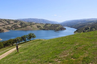
Del Valle Regional Park consists of 4,395 acres of rolling East Bay hills surrounding Lake Del Valle reservoir. The park is located about 10 miles south of Livermore. Lake Del Valle was created in 1968 with the construction of the Del Valle Dam as part of the California State Water Project. Today, the lake is a very popular summer destination for swimming, fishing, and boating.
Del Valle Regional Park offers about two dozen miles of trails that are primarily fire roads. Elevations in the park range from about 600' at the Arroyo Road Staging Area at the north end of the park, to over 1500' at the southwest corner of the park. The climbing is generally moderate with some steep sections. The landscape is typical East Bay grassy hills, which means expansive views but very little shade. Del Valle is also the start of the 28-mile Ohlone Wilderness Trail, which passes through Sunol Regional Wilderness and Mission Peak Regional Preserve and ends in Fremont. The high point of the Ohlone Wilderness Trail, 3,817' Rose Peak, is about 9.5 miles from the trailhead in Del Valle Regional park.
In addition to hiking and trail running, Del Valle Regional Park offers swimming, fishing, boating, picnicking, and camping. The park has two swimming beaches with lifeguards on duty during posted periods. Lake Del Valle is also known for excellent fishing. The lake is stocked regularly with trout and catfish. There are also large- and smallmouth bass, striped bass, and panfish. Del Valle also offers boat, canoe, and kayak rentals. The Del Valle Family Campground has 150 sites, some offering water, sewage, and electrical hook-ups. The sites are served by centrally located toilet and shower facilities. For more information or reservations, refer to the park website.
There are two ways to access the trails in Del Valle Regional Park. The main entrance and lake access is via Del Valle Road off of Mines Road. The trails can also be accessed via the Arroyo Road Staging Area at the north end of the park. From the Arroyo Road Staging area it is approximately 5 miles one-way along the East Shore Trail to reach the main trail system at the southern end of the lake.
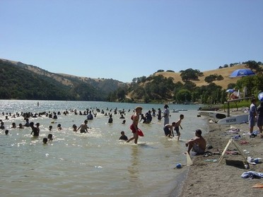 Swimming in Lake Del Valle
The Dirt:
Extras:
- Click here for the official park website with link to trail map.
- Click here for driving directions to the main park entrance via Del Valle Road. Note that there is a fee to drive into the park.
- Click here for driving directions to the Arroyo Road Staging Area at the north end of the park.
- Dogs are allowed, and may be off-leash away from trailheads, parking lots, and areas marked as on-leash only. Dogs are NOT allowed to swim in the reservoir. Refer to the East Bay Regional Park page on Dogs for more information.
Extras:
- Del Valle Regional Park also offers two swimming beaches, fishing, boat rentals, picnicking, and camping. Refer to the park website for more details
- Del Valle is at eastern end of the 28-mile Ohlone Wilderness Trail. Permits are required for hiking or overnight camping along the trail. This trail is also the route for the annual Ohlone 50k trail race.
- There is no drinking water available along the trails, so bring your own!
Favorite Run #1: Murietta Falls (12.4 mi, 4000' elevation gain) 🐾
|
You may be familiar with Berry Creek Falls in Big Basin Redwoods State Park, or the multiple cascades and falls in Uvas Canyon County Park. But did you know that the Bay Area's tallest waterfall lies in a remote rocky gorge in the East Bay hills? The 100-foot Murietta Falls is little-known for two reasons. First, seeing it requires a tough 12.4-mile run or hike with 4,000' of elevation gain. Second, the falls is completely dry for most of the year and only comes to life after it rains. So, the trip to Murietta Falls is best done in the early spring after heavy rains when the temperatures are moderate, the wildflowers are in bloom, and the falls are truly spectacular.
The route to Murietta Falls is an out-and-back along the Ohlone Wilderness Trail, starting from the Lichen Bark picnic area in Del Valle Regional Park. The trip to the falls is divided into four distinct segments. The first 2.4 miles is a 1600' climb up to Rocky Ridge. This is followed by a 0.8-mile descent to Williams Gulch. The next 2 miles is a 1400' climb up the Big Burn section. The last mile is a descent to the falls. Be sure to save some energy, as the return trip involves another 1000' of climbing! GPX Track Printable Trail Map Driving Directions |
|
Route Details:
Note: There is drinking water available at Stromer Spring and Stewart's Camp. However, the water is not guaranteed potable, so the EBRPD recommends that all water is filtered or boiled before drinking!
Note: There is drinking water available at Stromer Spring and Stewart's Camp. However, the water is not guaranteed potable, so the EBRPD recommends that all water is filtered or boiled before drinking!
|
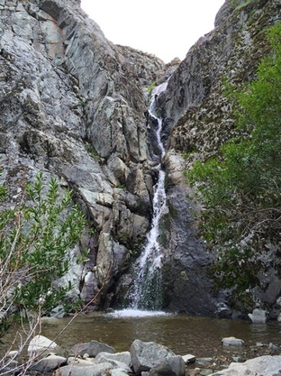
Murietta Falls in the springtime
|
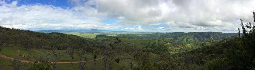
The view from Schlieper Rock