Annadel State Park
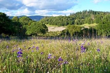
Annadel State Park is located about 60 miles north of San Francisco on the eastern edge of the city of Santa Rosa. The park has more than 5,500 mostly undeveloped acres of rolling hills, seasonal streams, meadows and woodlands. The name "Annadel" dates back to the late 1800's when the land was owned by the Hutchinson family. Samuel Hutchinson had named his ranch by combining the name of his daughter, Annie, with "dell" which means a small, secluded, wooded valley. Initially used for sheep and cattle grazing, the land soon became used for quarrying of cobblestones to build San Francisco and other west coast cities. However, in the 1920's the demand for cobblestones significantly declined.
Then, in the 1930's, entrepreneur Joe Coney bought the land to build a hunting and fishing retreat for his friends. Under the Coneys’ ownership, it became known as “the Annadel Farm.” He stocked the property with game birds and filled his man-made lake, Lake Ilsanjo, with black bass and other fish. When his fortunes began to diminish in the 1960's, Joe Coney decided to sell the ranch. California State Parks acquired Annadel in 1971, and it became a state park in 1974. Evidence of the cobblestone quarrying still exists today.
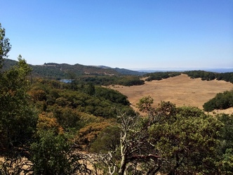
The park offers over 50 miles of rolling trails that are a mix of dirt roads and singletrack. In addition to hikers, runners, and equestrians, the trails are particularly popular with local mountain bikers enjoying the challenge of the technical, rocky trails. If you are running or hiking it is important to watch out for mountain bikers, particularly on the weekends. Elevations in the park range from about 300' at the entrance to over 1,400' at the high point of the park. In addition to trail use, the park allows fishing in Lake Ilsanjo with a valid California fishing license. The fishing for black bass and bluegill is excellent.
Annadel State Park was the last Sonoma Valley park on the state park closure list. It was saved in 2012 after the county’s Board of Supervisors unanimously approved a contract to allow Sonoma County Regional Parks to manage Annadel State Park for one year beginning July 2012. In July 2013 the State resumed operations of the park, with help from volunteers. The future of the park is still precarious, but hopefully with the help of donations and volunteers it can be kept open.
Then, in the 1930's, entrepreneur Joe Coney bought the land to build a hunting and fishing retreat for his friends. Under the Coneys’ ownership, it became known as “the Annadel Farm.” He stocked the property with game birds and filled his man-made lake, Lake Ilsanjo, with black bass and other fish. When his fortunes began to diminish in the 1960's, Joe Coney decided to sell the ranch. California State Parks acquired Annadel in 1971, and it became a state park in 1974. Evidence of the cobblestone quarrying still exists today.
The park offers over 50 miles of rolling trails that are a mix of dirt roads and singletrack. In addition to hikers, runners, and equestrians, the trails are particularly popular with local mountain bikers enjoying the challenge of the technical, rocky trails. If you are running or hiking it is important to watch out for mountain bikers, particularly on the weekends. Elevations in the park range from about 300' at the entrance to over 1,400' at the high point of the park. In addition to trail use, the park allows fishing in Lake Ilsanjo with a valid California fishing license. The fishing for black bass and bluegill is excellent.
Annadel State Park was the last Sonoma Valley park on the state park closure list. It was saved in 2012 after the county’s Board of Supervisors unanimously approved a contract to allow Sonoma County Regional Parks to manage Annadel State Park for one year beginning July 2012. In July 2013 the State resumed operations of the park, with help from volunteers. The future of the park is still precarious, but hopefully with the help of donations and volunteers it can be kept open.
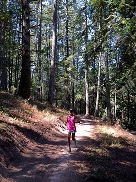
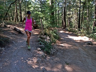
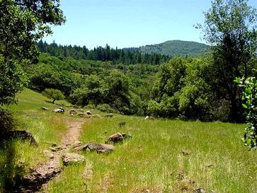 Rocky singletrack in Annadel Park
The Dirt:
Extras:
- Click here to download a printable trail map of the Favorite Runs below!
- Click here for the official Annadel State Park website with link to trail map.
- A better trail map with mileages is available here.
- Click here for driving directions to the Cobblestone Trailhead parking on Channel Drive via Google Maps.
- It is free to park at the Cobblestone Trailhead; however, a parking fee is required to park beyond the visitor center on Channel Drive.
- Dogs are not allowed on trails in the park.
Extras:
- Drinkable water is located near the visitor center and in the main parking lot at the east end of Channel Drive. No other water in the park is potable.
- Fishing is allowed in Lake Ilsanio with a valid California fishing license.
Favorite Run #1: Small Lake Loop (7.6 mi, ~1000' elevation gain)
|
This loop is a nice introduction to the park. It starts with a flat 1.6-mile warm-up, followed by a nice shaded climb through a dense forest. After a trip around Lake Ilsanjo, the route then follows the technical and rocky Rough-Go Trail and Cobblestone Trail, and ends with a mile descent back to your car.
This run starts from the Cobblestone Trailhead on Channel Drive. Park in the dirt area alongside Channel Drive, then begin the loop by running up Channel Drive toward the park entrance. GPX Track Printable Trail Map Driving Directions |
|
|
Route Details:
|
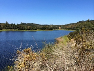
Lake Ilsanjo
The view from Warren Richardson Trail
|
Favorite Run #2: Big Lake Loop (11.6 mi, ~1600' elevation gain)
|
This loop is a longer version of Favorite Run #1 that includes a trip up to the high point of Annadel State Park at 1,427'. (Alas, there is no view from the high point...) This run starts with a flat 1.6-mile warm-up, followed by a nice shaded climb through a dense forest. The climb intensifies as it follows a rocky singletrack through a redwood grove up to the high point of the park. This is followed by three miles along a great rolling singletrack that slowly descends to Lake Ilsanjo. After a trip around Lake Ilsanjo, the route then follows the technical and rocky Rough-Go Trail and Cobblestone Trail, and ends with a mile descent back to your car.
This run starts from the Cobblestone Trailhead on Channel Drive. Park in the dirt area alongside Channel Drive, then begin the loop by running up Channel Drive toward the park entrance. GPX Track Printable Trail Map Driving Directions |
|
Route Details:
|
Climbing the South Burma Trail
Descending the Marsh Trail to Lake Ilsanjo
|