Black Diamond Mines Regional Preserve
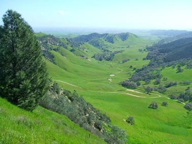
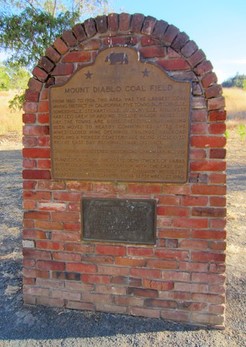
Black Diamond Mines Regional Preserve is located in the East Bay near Antioch. The preserve offers 65 miles of trails through over 6,000 acres of rolling grassy hills and valleys. The preserve gets its name from the extensive mining of coal or "black diamonds" that took place here. Before the discovery of coal, the land was primarily used for cattle ranching. After coal was discovered in the mid-1800's, the landscape changed dramatically. From the 1850's through the early 1900's, five coal mining towns thrived in the Black Diamond area: Nortonville, Somersville, Stewartville, West Hartley and Judsonville. A dozen mines supplied nearly four million tons of coal to the rapidly expanding San Francisco Bay Area. Rising production costs and the advent of oil as an energy source eventually ended production and turned the mining communities into ghost towns. Later, from the 1920's through the late 1940's, silica-rich sand was mined by the Hazel-Atlas Glass Company for the production of glass products and by the Roberts Sand Company for use in the Columbia Steel foundry. Altogether, more than 1.8 million tons of sand was mined.
Most of the preserve's 65 miles of trails are old dirt roads, with a few singletrack trails scattered throughout the park. Elevations range from around 300' to just over 1200' along the ridge. The climbs in the park range from moderate to steep. One important point is that there is almost no shade in the park, and summer temperatures can easily climb into the 90's or 100's. Also, the only drinking water in the park is at the main parking lot. So bring plenty of water and wear sunscreen!
In addition to running and hiking trails, there are two backpack camps in the preserve. The Star Mine Group Camp Area is available for group camping, and the Stewartville Backpack Camp is open for the general public. Reservations are required. Please refer to the preserve website for more details.
The Dirt:
Extras:
- Click here for a printable trail map of the Favorite Runs below!
- Click here for the official park site with link to trail map and campsite reservations.
- Click here for directions to the park via Google Maps.
- Dogs are allowed, and may be off-leash away from trailheads, parking lots, and areas marked as on-leash only. Refer to the East Bay Regional Park page on Dogs for more information. Note that dogs are NOT allowed on the mine tours!
Extras:
- Drinking water is available only at the Visitors Center and at the main parking area, so bring water along on your hike or run!
- There are several historical mining features that we recommend visiting when in the preserve. Please see the next section for details.
- There are two backpack camps in the preserve. Please refer to the preserve website for more details.
Exploring the Preserve's Mining History
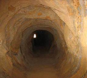
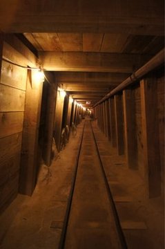 The restored Hazel-Atlas tunnel
Today, almost all signs of the thriving towns and extensive mining operations are gone. When the coal mines closed in the early 20th century, many of the buildings were dismantled and moved to nearby communities. Others were eventually destroyed by fire or vandals. However, there are few remaining historic sites within the preserve that are interesting to visit:
- The Greathouse Visitor Center and museum is located in an underground room excavated by the silica-sand miners in the 1920's.
- A 950-foot section of Hazel-Atlas Sand Mine has been restored to appear as it did when the mine was active. Guided tours are available, and tickets can be purchased at the Greathouse Visitor Center.
- A 200-foot section of the Prospect Tunnel coal mine is open for anyone to explore, but you will need a light! This tunnel was driven in the 1860's by miners in search of commercial-quality coal.
- Rose Hill Cemetery is the final resting place of around 250 people who died between 1860 and 1900, and many old tombstones remain.
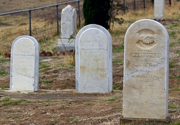
Rose Hill Cemetery
|
The Prospect Tunnel
|
Favorite Run #1: Stewartville-Ridge Loop (7.0 mi, ~1300' elevation gain) 🐾
|
This run is a great introduction to the Black Diamond Mines Regional Preserve. The run starts with a nice mile climb up the Stewartville Trail followed by a descent to the old Stewartville townsite. After a brief diversion into the Prospect Tunnel (bring a flashlight or headlamp!) you get a nice climb up the Ridge Trail followed by a final descent on the Stewartville Trail back to your car.
This run starts from the main parking lot. From the parking lot, head south along the main trailhead toward the visitor center, and turn onto the Stewartville Trail. GPX Track Printable Trail Map Driving Directions |
|
Route Details:
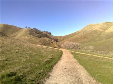 The Stewartville Trail
- 0.0 mi: From the parking lot, head south along the main trailhead toward the visitor center, and turn onto the Stewartville Trail. You will soon begin climbing up to a saddle. Continue on the Stewartville trail for the next 4 miles or so.
- 0.9 mi: At the first high point! Continue to follow the Stewartville trail. You will descend into a valley, then pass the old Stewartville townsite.
- 3.0 mi: You will pass a small trail heading up to the Prospect Tunnel on your left. Head up this 0.15-mile trail and explore the old tunnel. The first 200' are accessible if you have a flashlight. Then return to the Stewartville Trail and continue in the direction you were heading.
- 4.2 mi: Turn left onto the Ridge Trail and begin the 2-mile climb up to the high point. There are nice views from along this ridge. Stay on the Ridge Trail until it intersects the Stewartville Trail.
- 6.1 mi: Just after the high point, turn right onto the Stewartville Trail to descend back to the parking lot and your car.
- 7.0 mi: Back at your car!
Favorite Run #2: Big Figure-8 (10.5 mi, ~1800' elevation gain) 🐾
|
This run is the grand tour of Black Diamond Mines Regional Preserve. The first 4 miles follow the same route as Favorite Run #1. But this route adds a nice rolling section through the east side of the park followed by a very challenging climb up the Old Homestead and Acorn Trails. After running along the ridge and taking in the views, the loop ends with a nice descent back to your car.
This run starts from the main parking lot. From the parking lot, head south along the main trailhead toward the visitor center, and turn onto the Stewartville Trail. GPX Track Printable Trail Map Driving Directions |
|
Route Details:
- 0.0 mi: From the parking lot, head south along the main trailhead toward the visitor center, and turn onto the Stewartville Trail. You will soon begin climbing up to a saddle. Continue on the Stewartville trail for the next 4 miles or so.
- 0.9 mi: At the first high point! Continue to follow the Stewartville trail. You will descend into a valley, then pass the old Stewartville townsite.
- 3.0 mi: You will pass a small trail heading up to the Prospect Tunnel on your left. Head up this 0.15-mile trail and explore the old tunnel. The first 200' are accessible if you have a flashlight. Then return to the Stewartville Trail and continue in the direction you were heading.
- 4.2 mi: Pass the Ridge Trail on your left. Continue on the Stewartville Trail until it ends in a parking area.
- 5.2 mi: At the Frederickson Road parking area. Turn left onto Homestead Trail.
- 5.4 mi: Continue straight onto Old Homestead Loop (do not turn left). Old Homestead Loop will climb a bit, flatten out, then veer left and climb steeply up a valley. The climb is very challenging!
- 7.3 mi: Turn right onto Acorn Trail and continue climbing.
- 7.8 mi: Turn right onto Ridge Trail. The climbing is almost done!
- 8.3 mi: Just past the high point, turn right onto Stewartville Trail, then an immediate right onto Carbondale Trail. Continue on Carbondale Trail until it ends. There are some nice views from this trail.
- 9.4 mi: Hard left turn onto River View Trail. There is one brief climb followed by a descent.
- 10.3 mi: River View Trail ends on Railroad Bed Trail. Turn right to head back to the parking lot.
- 10.5 mi: Back at the parking lot and your car!!