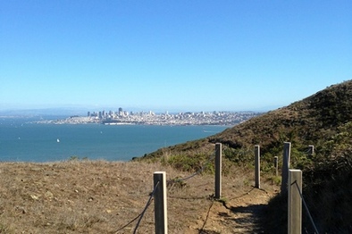
Bolinas Ridge to San Francisco (32.9 mi, 4900' elevation gain)
|
This amazing route is the course for the spectacular BayTrailrunners Coastal Marin 50k. This amazing route through Marin extends all of the way from Bolinas Ridge near Point Reyes Station to San Francisco. Along the way, the route passes through some of the most spectacular terrain the Bay Area has to offer, including the Golden Gate National Recreation Area (GGNRA), Mount Tamalpais State Park, and Muir Woods National Monument. And as if that was not enough, the last two miles take you across the Golden Gate Bridge to finish in San Francisco!
Now for the logistics of the run. This is a point-to-point run, meaning that you need to arrange a drop-off at the starting location and a pick-up at the end. Also, there is only one water stop, located halfway through the run at Pantoll Ranger Station. This means that you need to carry enough water with you to be self-sufficient for sixteen miles. The route consists of approximately one-third fire roads and two-thirds singletrack. Less than half of the route is shaded. Along the way, you will have excellent views of the Marin hills, the Pacific Ocean, Mount Tamalpais, San Francisco, and the Golden Gate Bridge. Even though there is 4900' of climbing, most of the climbs are moderate with few steep sections. Important Note! The trails are marked fairly well but there are several places where it is easy to get lost. So it is very important to bring a map or download the GPX track and confirm you are on the correct trail. |
|
The run starts from the Bolinas Ridge Trailhead along Sir Francis Drake Blvd, 1.1 miles east of Highway 1. There is a dirt pull-out that is large enough to park a few cars. To begin the run, simply head through the gate onto the Bolinas Ridge Trail and start heading south.

The Dirt:
- Click here for a printable 4-page trail map of the route.
- Click here to download the GPX track of the route.
- Purchase the National Geographic map of the Point Reyes/Mount Tam region through the Trailstompers Store!
- Click here for driving directions to the start of the run (Bolinas Ridge Trailhead on Sir Francis Drake Blvd)
- Click here for driving directions to the end of the run (Golden Gate Bridge Plaza parking lot)
- There is only one water stop, at mile 17.3!
- Scroll to the bottom of the page for a slide show of the route!
- This route is NOT dog-friendly. :(
Route Details:
- 0.0 mi: From the trailhead on Sir Francis Drake Blvd, head south on the Bolinas Ridge Trail. The trail is an old dirt road that you will follow as it gradually climbs for the next 11 miles to Bolinas-Fairfax Road.
- 11.1 mi: Cross over Bolinas-Fairfax Road and get onto the singletrack Coastal Trail. After a brief section in the woods, the trail then traverses the sides of the grassy coastal hills for spectacular views of the Pacific Ocean. You will follow the coastal trail for the next 4.6 miles.
- 13.0 mi: Continue onto the shoulder of Ridgecrest Blvd for about 500 feet, then veer right to rejoin the Coastal Trail.
- 14.1 mi: Intersection with Willow Camp Fire Road. Turn left, then immediately turn right to stay on Coastal Trail.
- 15.7 mi: Coastal Trail ends at Matt Davis Trail. Continue straight ahead onto Matt Davis Trail toward Pantoll Ranger Station.
- 17.3 mi: (Water available) At Pantoll Ranger Station. After filling up with water, follow signs to get onto the singletrack Old Mine Trail.
- 17.8 mi: At the clearing, continue onto the fire road, then turn left onto the Dipsea Trail. Shortly thereafter, veer onto Deer Park Fire Road. Over the next mile, the Dipsea Trail and Deer Park Fire Road will cross several times, but always stay on Deer Park Fire Road as it descends to Muir Woods.
- 20.2 mi: Cross Muir Woods Road, then get onto the singletrack Redwood Creek Trail. Keep an eye out for the Miwok Trail on your left.
- 20.5 mi: Turn left onto Miwok Trail and start climbing. You will follow the Miwok Trail for the next five miles.
- 22.2 mi: Miwok Trail temporarily joins with Dias Ridge Fire Road, then veers off to the right. Veer right to stay on Miwok Trail.
- 22.7 mi: Cross Highway 1 and continue on Miwok Trail, which now turns to a fire road. Over the next three miles there will be several trail junctions, but keep following Miwok Trail all of the way down to Tennessee Valley.
- 25.8 mi: At Tennessee Valley Trailhead. Veer right, then cross through the parking lot toward the stables. Before reaching the stables, turn left onto Marincello Trail, which climbs for the next 1.5 miles up to the ridge.
- 27.4 mi: Continue straight onto Bobcat Trail.
- 28.2 mi: Jog left, then right onto Morning Sun Trail.
- 28.8 mi: Morning Sun Trail ends at Wolfback Ridge Road. Continue straight ahead and veer slightly right onto the singletrack SCA Trail.
- 29.9 mi: Veer left onto the Coastal Trail. You should catch your first glimpse of the Golden Gate Bridge soon! Follow the Coastal Trail all of the way down to the Golden Gate Bridge.
- 30.8 mi: Cross Conzelman Road and continue on the Coastal Trail toward the bridge.
- 31.0 mi: Trail ends at the Golden Gate Bridge pedestrian parking area. Continue through the parking area to the stairway that leads under the bridge to the opposite side, then get on the pedestrian walkway heading toward San Francisco.
- 32.8 mi: At the other side of the bridge. Head through the pedestrian area toward the Golden Gate Bridge Pavilion parking lot, where your ride is waiting!
- 32.9 mi: At the parking lot!
|
|