Briones Regional Park
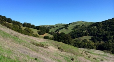
Briones Regional Park encompasses over 6,000 acres of rolling grassland in the East Bay hills. Even though the park is close to close to the cities of Lafayette, Walnut Creek, Pleasant Hill, Concord, and Martinez, many areas of Briones feel like wilderness. The park features picnic areas, walk-in campgrounds, and over two dozen miles of trails. Elevations in the park range from around 400 feet on the eastern side to over 1400 feet along the Lafayette Ridge. Briones Peak, the highest point in the park at 1483 ft, offers panoramic views of Mount Diablo to the east, the Sacramento River to the north, and the Berkeley Hills and Mt. Tamalpais to the west.
The trails in Briones Regional Park are primarily fire roads, with climbing ranging from mild to moderate. The trails leading up to the ridge are steeper and will definitely get your heart pumping! There is little shade in the park, which makes for great unobstructed views but also means that the trails can be very hot in the summer. So, wear sunscreen and be sure to bring plenty of water in the summertime!
The trails in Briones Regional Park are primarily fire roads, with climbing ranging from mild to moderate. The trails leading up to the ridge are steeper and will definitely get your heart pumping! There is little shade in the park, which makes for great unobstructed views but also means that the trails can be very hot in the summer. So, wear sunscreen and be sure to bring plenty of water in the summertime!
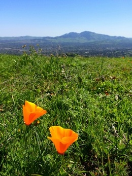 Poppies along Table Top Trail
The name "Briones" refers to Felipe and Maria Briones, who lived near what is now the Bear Creek Staging Area. The couple farmed and raised cattle on the land. After Felipe's passing, Maria petitioned the Governor for a grant to the land the family had occupied, which was issued in 1842. The land was acquired by the East Bay Municipal Utility District (EBMUD) in the early 1900's and officially opened as a Regional Park in 1967.
There are multiple Staging Areas providing access to the trails in Briones Regional Park. All of the runs on this page start from the main Bear Creek Staging Area off of Bear Creek Road. After passing the entrance kiosk, take the first left turn into the paved parking area.
The Dirt:
Extras:
There are multiple Staging Areas providing access to the trails in Briones Regional Park. All of the runs on this page start from the main Bear Creek Staging Area off of Bear Creek Road. After passing the entrance kiosk, take the first left turn into the paved parking area.
The Dirt:
- Click here to download a printable map of the Favorite Runs below!
- Click here for the Briones Regional Park website with a link to the trail map.
- Click here for driving directions to the Bear Creek Staging Area via Google maps.
- Dogs are allowed, and may be off-leash away from trailheads, parking lots, and areas marked as on-leash only. Refer to the East Bay Regional Park page on Dogs for more information.
Extras:
- There is drinking water available at several locations in the park, please refer to the park map for locations. It is always a good idea to contact the park to make sure the water is available and potable.
Favorite Run #1: Briones Peak Climb (5.1 mi, ~800 feet elevation gain) 🐾
|
This run takes you on an 800-foot climb up the Old Briones Road Trail and then on a loop over Briones Peak. There are great views of Mount Diablo and Mount Tamalpais from the trails near the peak.
To begin this run, head out to the main park road and turn left. Continue up the road past the gate onto Old Briones Road Trail. GPX Track Printable Trail Map Driving Directions |
|
|
Route Details:
|
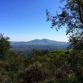
View of Mt. Diablo from Briones Peak
|
Favorite Run #2: Briones Crest Loop (7.9 mi, ~1200 feet elevation gain) 🐾
|
This run is a great loop along the pretty Lafayette Ridge. After about a mile of steep climbing, the trail rolls along the ridge gradually climbing up to 1,483' Briones Peak. After the peak, this route takes a brief diversion on the Table Top Trail, which offers spectacular views of Mount Diablo to the east. Then it's time for a two-mile descent back to your car!
Start this run from the parking area by following signs for the Briones Crest Trail. GPX Track Printable Trail Map Driving Directions |
|
|
Route Details:
|
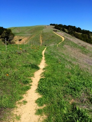
Climbing up Briones Crest Trail
|