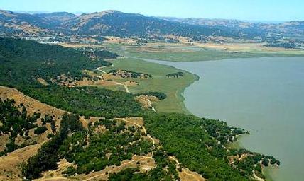
China Camp State Park
In the early to mid 1800's, Chinese workers served across California as laborers in gold mines and builders of the transcontinental railroad. After the gold rush and the completion of the railroad, the demand for Chinese laborers abated and the Chinese had to find other work. Some of these Chinese workers turned to fishing. By the early 1880's, China Camp was a successful coastal fishing village along the shore of San Pablo Bay with nearly 500 residents. The bay’s mud flats provided an ideal grass-shrimping location. Nearly three million pounds of shrimp were caught each year, then dried and exported to China.
Today, there is little remaining evidence of the thriving fishing village. In its place is a beautiful park situated along the shores of the San Pablo Bay, about a half-hour drive north of San Francisco. China Camp State Park offers 15 miles of trails, perfect for biking, hiking, or trail running. Elevations in the park range from sea level to approximately 800 feet, with a few great climbs and long, sweeping descents. The ridge offers stunning views of the San Pablo Bay to the north and San Francisco to the south.
There are multiple park entrances along North San Pedro Road. The Favorite Runs on this page start from the Miwok Meadows Day-Use Area. Parking is along the shoulder of North San Pedro Road. Note that there is no fee to park along North San Pedro Road, but there is a small fee to use the trails in China Camp State Park. This fee directly supports the maintenance and continued operation of the park.
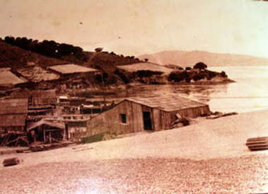 Early photo of China Camp (friendsofchinacamp.org)
The Dirt:
Extras:
- Click here to download a printable trail map of the Favorite Runs below!
- Click here for the official park site with trail maps.
- Click here for directions to the Miwok Meadows Trailhead parking along the side of North San Pedro Road.
- There is a fee to park inside the park, but there is no fee to park along North San Pedro Road; however, you are still required to pay a small trail use fee. Please see the Friends of China Camp website for more information on the fees.
- Dogs are not allowed on the trails in China Camp.
Extras:
- Back Ranch Meadows campground offers hike-in sites for tent-camping. Refer to the official park website for details.
- There is NO drinking water available in the park!!
Saving China Camp State Park!

In 2011, China Camp was put on the official list of around 70 California State Parks that were slated for closure due to budget problems. This closure was ultimately averted with legislation that allowed Friends of China Camp to enter into an agreement with California State Parks to operate the park and keep it open. To keep the park operating, parking and trail use fees have been instituted. Please help keep China Camp open by paying the fees!
Favorite Run #1: Ridge Loop (6.8 mi, ~600' elevation gain)
|
This is a great loop with a fairly steep and rocky climb near the beginning followed by miles of rolling or downhill singletrack as your reward. As an added bonus, this loop has great views of San Pablo Bay to the north, and Sausalito and San Francisco to the south.
To start the run, park along North San Pedro Road and start running up the dirt access road toward the Miwok Meadows Day-Use Area. GPX Track Printable Trail Map Driving Directions |
|
Route Details:
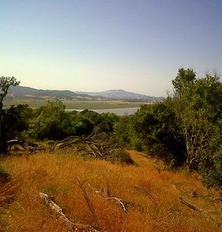 San Pablo Bay from Bay View Trail
- 0.0 mi: Start up the dirt road toward the Miwok Meadows Day-Use Area.
- 0.4 mi: At the Miwok Meadows Day-Use Area, veer right through the parking area and continue onto Shoreline Trail (singletrack). Continue following the Shoreline Trail singletrack for the next 1.5 miles toward the campground.
- 1.8 mi: Major intersection with the Back Ranch Fire Trail. Turn left on Back Ranch Fire Trail and start climbing steeply.
- 2.3 mi: Turn left onto the Bay View Trail (singletrack). Enjoy the views as you continue on the Bay View Trail for the next 1.6 miles.
- 3.5 mi: Continue onto the Oak Ridge Trail (also singletrack). In the next mile you will cross a fire road twice.
- 4.5 mi: After the second fire road crossing, the Oak Ridge Trail will switchback a few times. After the switchbacks, take a brief left onto the Peacock Gap Trail, then continue left onto the Shoreline Trail toward the Miwok Meadows area (do not head toward the "park boundary"). You will follow the Shoreline Trail for the next two miles.
- 6.7 mi: Shoreline Trail veers onto the dirt road where you entered the park. Turn right to head back out to your car.
- 6.8 mi: Back at your car!
Favorite Run #2: Bay View Climb Loop (7.1 mi, ~800' elevation gain)
|
This lolly-pop loop has a great, switchback climb followed by a rocky, steep descent. This route is a great hill training run with some killer views of the Bay!
To start the run, park along North San Pedro Road and start running up the dirt access road toward the Miwok Meadows Day-Use Area. GPX Track Printable Trail Map Driving Directions |
|
Route Details:
- 0.0 mi: Start up the dirt road toward the Miwok Meadows Day-Use Area.
- 0.4 mi: At the Miwok Meadows Day-Use Area, veer right through the parking area and continue onto Shoreline Trail (singletrack). Continue following the Shoreline Trail singletrack for the next 1.5 miles toward the campground.
- 1.8 mi: Major intersection with the Back Ranch Fire Trail. Continue straight on the Shoreline Trail toward the Bay View Trail.
- 2.5 mi: Turn left onto the Bay View Trail, and prepare to start climbing! You will cross a fire road but stay on the singletrack Bay View Trail.
- 4.7 mi: Turn left onto the Back Ranch Fire Trail and start a rocky, steep descent.
- 5.2 mi: Turn right onto the Shoreline Trail to head back to the car the way that you came.
- 6.7 mi: Back at the Miwok Meadows Day Use Area. Continue out the dirt road back to your car.
- 7.1 mi: Back at your car!
Favorite Run #3: China Camp Big Loop (9.2 mi, ~900' elevation gain)
|
This loop is a combination of Favorite Runs #1 and #2, covering the entire perimeter of China Camp State Park. You get to experience the great singletrack climb up Bay View Trail, then the rolling singletrack along the ridge, followed by the swooping downhill on Oak Ridge Trail. There are some beautiful views from the Bay View and Oak Ridge Trails.
To start the run, park along North San Pedro Road and start running up the dirt access road toward the Miwok Meadows Day-Use Area. GPX Track Printable Trail Map Driving Directions |
|
Route Details:
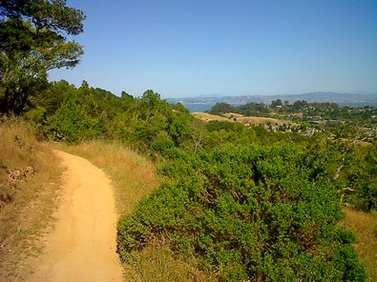 Oak Ridge Trail
- 0.0 mi: Start up the dirt road toward the Miwok Meadows Day-Use Area.
- 0.4 mi: At the Miwok Meadows Day-Use Area, veer right through the parking area and continue onto Shoreline Trail (singletrack). Continue following the Shoreline Trail singletrack for the next 1.5 miles toward the campground.
- 1.8 mi: Major intersection with the Back Ranch Fire Trail. Continue straight on the Shoreline Trail toward the Bay View Trail.
- 2.8 mi: Turn left onto the Bay View Trail, and prepare to start climbing! You will cross a fire road but stay on the singletrack Bay View Trail. Stay on the Bay View Trail for the next 4 miles.
- 4.7 mi: Intersection with Back Ranch Fire Trail. Continue on the Bay View Trail. Enjoy the views on the Bay View Trail as it follows the ridge.
- 5.9 mi: Continue onto the Oak Ridge Trail (also singletrack). In the next mile you will cross a fire road twice.
- 6.8 mi: After the second fire road crossing, the Oak Ridge Trail will switchback a few times. After the switchbacks, take a brief left onto the Peacock Gap Trail, then continue left onto the Shoreline Trail toward the Miwok Meadows area (do not head toward the "park boundary").
- 9.1 mi: Shoreline Trail veers onto the dirt road where you entered the park. Turn right and head back out to your car.
- 9.2 mi: Back at your car!