Garin and Dry Creek Regional Parks
Garin and Dry Creek Regional Parks are two adjoining parks located in the hills just east of Hayward. Garin Regional Park is the site of the former Garin Ranch, sold by Andrew J. Garin to the district in 1966. Dry Creek Ranch was owned by three sisters, Edith, Mildred, and Jeanette Meyers, who were involved in local charities and fundraisers during the early and mid 1900's. The Dry Creek Ranch was donated to the Park District in 1979 and later opened as Dry Creek Regional Park. Today, the two parks offer a combined 4,794 acres with more than 20 miles of trails.
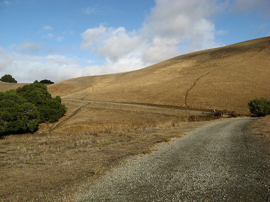
The parks feature quintessential East Bay hills: green and grassy in the winter, and golden-brown in the summer. Elevations in the park range from a few hundred feet near the entrance to just over 1100'. From the high point along High Ridge Loop Trail there are nice views of the San Francisco Bay and surrounding cities. Most of the trails in the park are fire roads, with the exception of the Zeile Creek Trail and Garin Woods Trail at the northern end of Garin Regional Park.
In addition to trails, there are several historical sites within the parks. The Garin Barn Visitor Center displays artifacts from the ranching and farming history of the Hayward area. There is a blacksmith shop, a tool shop and several ranching-related displays to explore. An interesting collection of antique farm machinery outside the barn augments the display. Meyers Cottage was the popular summer home of Edith, Mildred, and Jeanette Meyers. Upon the passing of the last surviving Meyers sister, the Meyers Cottage and its garden was also donated to the Park District.
A few words of caution about trail running in Garin / Dry Creek. There is almost no shade in the parks, and it can get very hot in the summer! So wear a hat and sunscreen, and bring extra water! Also, there are a few places where unmarked trails branch off from the main trail, and these trails are not marked on the map. In general, if the trail is not marked, then it is not the correct trail.
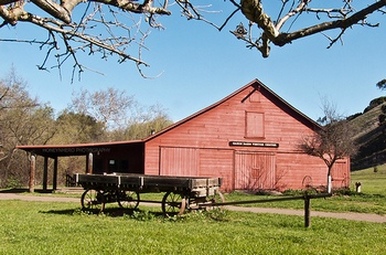 The Garin Barn Visitor Center
The Dirt:
Extras:
- Click here to download a printable trail map of the favorite runs below!
- Click here for the official website with trail map.
- Click here for driving directions to the main parking lot off Garin Ave.
- Dogs are allowed in both parks, and may be off-leash away from trailheads, parking lots, and areas marked as on-leash only. Refer to the East Bay Regional Park page on Dogs for more information.
Extras:
- Drinking water is available only at the Visitor Center.
- There is another trailhead with parking located at the end of May Road (Whipple Ave turns to May after crossing Mission Blvd). This is also the site of the Meyers Cottage.
- The Garin Barn Visitor Center displays artifacts from the ranching and farming history of the Hayward area.
Favorite Run #1: High Ridge Loop (6.6 mi, ~1200 feet elevation gain) 🐾
|
This route takes you up the narrow Newt Pond Trail to High Ridge for great vistas of the East Bay. After reaching a high point of over 1100', you take a brief detour around Gossip Rock followed by a great descent back down to the creek. You then follow the lower ridge back to your car.
Start this run by heading up the Old Homestead Trail at the far north end of the parking area. GPX Track Printable Trail Map Driving Directions |
|
Route Details:
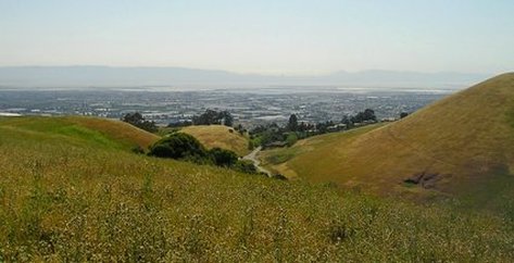 The view from High Ridge Trail
- 0.0 mi: From the far north end of the parking area, start heading up the Old Homestead Trail.
- 0.4 mi: Turn right onto the narrow Newt Pond Trail. This narrow trail switches back and forth up to the High Ridge Loop Trail (fire road).
- 0.8 mi: Turn left onto High Ridge Loop Trail. You will follow this trail along the high ridge.
- 2.4 mi: Turn left to take a brief side trip around Gossip Rock. This is a small lollypop loop. When you return, turn left to continue down High Ridge Loop Trail.
- 3.8 mi: Confusing unmarked intersection. Stay right to continue down High Ridge Loop Trail.
- 4.6 mi: Turn right to continue on High Ridge Loop Trail.
- 4.9 mi: Turn right on May Trail.
- 5.1 mi: Brief zig-zag right/left to get onto Ridge Loop Trail. You will follow this trail all of the way back to the car.
- 6.3 mi: At Jordan Pond. Continue alongside the pond back to the parking lot.
- 6.6 mi: Back at your car!
Favorite Run #2: Big Figure-8 (10.6 mi, ~1900 feet elevation gain) 🐾
|
This route combines the loop in Favorite Run #1 with a smaller loop around Garin Regional Park that includes the singletrack Garin Woods Trail, one of the longest bits of singletrack in the park. The loop also includes a nice section of shaded trail alongside Zeile Creek.
Start this run by heading up the Old Homestead Trail at the far north end of the parking area. GPX Track Printable Trail Map Driving Directions |
|
Route Details:
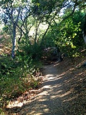 The shaded Garin Woods Trail
- 0.0 mi: From the far north end of the parking area, start heading up the Old Homestead Trail.
- 0.3 mi: Turn left onto Vista Peak Loop Trail. You will follow this trail for the next 1.5 miles. (Note: Stay left at the next two trail junctions.)
- 1.8 mi: Just past the equestrian building, turn right onto Zeile Creek Trail.
- 2.0 mi: Turn right onto Garin Woods Trail (upper trail). This is a narrow, shaded singletrack.
- 2.4 mi: Unmarked junction: Take the hard switchback to the left to continue on the Garin Woods Trail.
- 2.5 mi: After a brief descent, turn right to continue on the Garin Woods Trail. This will shortly join up with Zeile Creek Trail again, and you will begin a brief climb.
- 3.3 mi: Hard left turn onto Vista Peak Loop Trail.
- 4.1 mi: Turn left onto Vista Peak Loop Trail.
- 4.3 mi: Back on Old Homestead Road. Turn left and then turn right onto the narrow Newt Pond Trail. This narrow trail switches back and forth up to the High Ridge Loop Trail (fire road).
- 4.8 mi: Turn left onto High Ridge Loop Trail. You will follow this trail along the high ridge.
- 6.4 mi: Turn left to take a brief side trip around Gossip Rock. This is a small lollypop loop. When you return, turn left to continue down High Ridge Loop Trail.
- 7.8 mi: Confusing unmarked intersection. Stay right to continue down High Ridge Loop Trail.
- 8.6 mi: Turn right to continue on High Ridge Loop Trail.
- 8.9 mi: Turn right on May Trail.
- 9.1 mi: Brief zig-zag right/left to get onto Ridge Loop Trail. You will follow this trail all of the way back to the car.
- 10.3 mi: At Jordan Pond. Continue alongside the pond back to the parking lot.
- 10.6 mi: Back at your car!