Garrapata State Park
The 2,939-acre Garrapata State Park is located about 10 miles south of Monterey along Highway 1. What was once a cattle and sheep ranch is now a spectacular state park. The park offers about 8 miles of challenging trails through classic Big Sur hills and canyons. While the park is beautiful year-round, it is particularly impressive in the spring when the hills are covered in wildflowers.
The trails in Garrapata State Park are exclusively singletrack, and much of it is extremely steep. However, your efforts are rewarded with stunning views of the rugged Pacific Ocean coastline from the top of the ridge. The elevations in the park range from sea level to just under 2000' at Doud Peak. The steepest trail in the park is the back side of Rocky Ridge Trail (the section that descends from the ridge to Soberanes Creek). The official park website lists this trail as closed indefinitely; however, as of April 2014 there are no signs indicating that the trail is closed and the trail is well-traveled. It is loose and washed out in places, though, so be careful when heading down this section.
The trails in Garrapata State Park are exclusively singletrack, and much of it is extremely steep. However, your efforts are rewarded with stunning views of the rugged Pacific Ocean coastline from the top of the ridge. The elevations in the park range from sea level to just under 2000' at Doud Peak. The steepest trail in the park is the back side of Rocky Ridge Trail (the section that descends from the ridge to Soberanes Creek). The official park website lists this trail as closed indefinitely; however, as of April 2014 there are no signs indicating that the trail is closed and the trail is well-traveled. It is loose and washed out in places, though, so be careful when heading down this section.
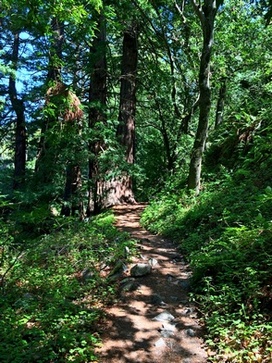 Redwoods along Soberanes Canyon Trail
As an interesting side note, when entering Soberanes Canyon you will find an entire hillside covered in hundreds of prickly pear cactus. Apparently this non-native cactus was brought north from Mexico by Spanish missionaries. The fruit of the prickly pear cactus is quite good; however, the prickly thorns and thick poison oak seems to keep anyone from harvesting it.
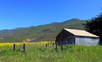
There are two trailheads for Garrapata State Park along Highway 1. The park is not well marked so the trailheads are easy to miss. The run featured on this page starts from the Soberanes Canyon Trailhead, which is the southernmost of the two trailheads. The Soberanes Canyon Trailhead is marked by a sign and trail map. There is dirt roadside parking for about a dozen cars at the trailhead.
The Dirt:
Extras:
There are two trailheads for Garrapata State Park along Highway 1. The park is not well marked so the trailheads are easy to miss. The run featured on this page starts from the Soberanes Canyon Trailhead, which is the southernmost of the two trailheads. The Soberanes Canyon Trailhead is marked by a sign and trail map. There is dirt roadside parking for about a dozen cars at the trailhead.
The Dirt:
- Click here to download a printable map of the Favorite Run below!
- Click here for the official website with a link to the trail map.
- Click here for driving directions to the Soberanes Canyon Trailhead via Google maps.
- There are no dogs allowed in the park.
Extras:
- There is no drinking water available in the park.
Favorite Run: Doud Peak Loop (5.8 mi, ~1900 feet elevation gain)
|
This spectacular loop takes you up the steep Rocky Ridge Trail to the top of the ridge for amazing views of the Pacific Ocean. Then, after a short out-and-back to Doud Peak (which is really nothing more than a grassy "bump"), you're faced with a knee-knocking descent, losing over 1500' in only one mile. The final portion of the route follows Soberanes Creek through a peaceful redwood grove and back out to Highway 1.
Note that backside of the Rocky Ridge Trail (the section that descends from the ridge to Soberanes Creek) is quite steep, washed out, and loose in places, so please be careful and watch your footing! GPX Track Printable Trail Map Driving Directions |
|
Route Details:
|
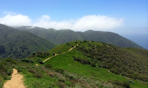
The spectacular (and steep) Rocky Ridge Trail
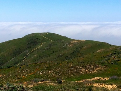
The view from Doud Peak
|