Trailstompers Guide to SF Bay Area Trail Running
  • Home
  • About
  • Links
  • FAQ
  • Contact

Long Ridge to Portola Redwoods and back (14.6 mi, ~2800 feet elevation gain)

This challenging run links Long Ridge Open Space Preserve and Portola Redwoods State Park via Ward Road. The first half of the run is entirely downhill as you drop into a beautiful redwood-filled canyon. After a brief rest at the Park Office, it's time to head back up the hill for the second half. Be warned: the climb is fairly steep in sections. In one 3-mile stretch you gain over 1500 feet!

The run starts from the Hickory Oaks Trailhead on Skyline Blvd, about 1.5 miles north of the Hwy 9 junction at Saratoga Gap. Heading north from Saratoga Gap, the trailhead will be on your left side. There is a dirt roadside parking area along Skyline Blvd near the trailhead that is large enough to fit several cars.

GPX Track

Printable Trail Map

Driving Directions
Route Details:

Important! Due to the drought of 2014 the water at the Portola Redwoods State Park Office may be shut off. Check with the Park Office to find out the current status!
  • 0.0 mi: From the parking area, run along the side of Skyline Blvd to the Hickory Oaks Trailhead. 
  • 0.1 mi: Turn right through the gate onto Hickory Oaks Trail. After a few hundred feet, you'll pass the Achistaca Trail on your left. Veer right to stay on the Hickory Oaks Trail.
  • 0.3 mi: The trail splits. You can go either direction, as both trails meet shortly.
  • 0.9 mi: Veer left to stay on the Hickory Oaks Trail
  • 1.4 mi: Hickory Oaks Trail ends on Ward Road. Turn left onto Ward Road and start really descending!
  • 1.8 mi: Pass Ranch Spring Trail on your right. Stay on Ward Road.
  • 2.0 mi: Enter Portola Redwoods State Park.
  • 2.9 mi: You reach a gate across Ward Road. Turn right on the singletrack to head down Slate Creek Trail. The next few miles are beautiful singletrack. 
  • 3.7 mi: Cross Slate Creek. You will soon pass the old Page Mill Site.
  • 4.5 mi: At the Slate Creek Trail Camp. Continue on the Slate Creek Trail.
  • 5.8 mi: Intersection with the Summit Trail. Turn right to continue on Slate Creek Trail toward the Park Office.  
  • 6.7 mi: Turn left to stay on Slate Creek Trail, heading toward the Park Office.
  • 7.1 mi: Right turn to stay on Slate Creek Trail, heading toward the Park Office.
  • 7.2 mi: Slate Creek Trail ends. Turn right on the paved road, then left at the main road.  Cross a bridge and the Park Office will be on your left.
  • 7.4 mi: (Water Available) At the Park Office. Get water!  Then retrace your steps by exiting from the Park Office, turning right, and then turning right again on the other side of the bridge. On the return, don't get back on Slate Creek Trail. Instead, continue up the Service Road toward Old Haul Road.  Keep an eye out for Summit Trail on your left.
  • 8.0 mi: Turn left onto Summit Trail. Begin short but steep climb!
  • 8.8 mi: At "The Summit". Just past the summit, veer right to get back onto Slate Creek Trail heading toward Slate Creek Trail Camp. After this point, you will just retrace your steps back to your car.
  • 9.9 mi: Pass Slate Creek Trail Camp. Stay on Slate Creek Trail.
  • 10.9 mi: Cross Slate Creek and really start climbing!
  • 12.9 mi: Enter Long Ridge OSP.
  • 13.4 mi: Turn right onto Hickory Oaks Trail.
  • 14.6 mi: Back at the car!
Picture
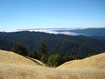
Looking down into Portola Redwoods State Park
Picture
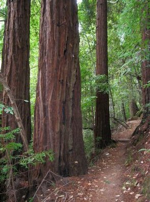
Slate Creek Trail in Portola Redwoods SP

Comments:

© 2021 Trailstompers.com.  All rights reserved.
Advertise on Trailstompers