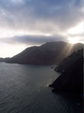
The Marin Headlands
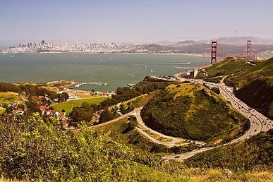
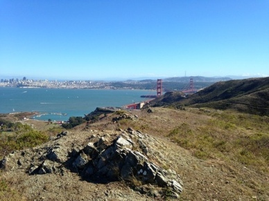
One of the most unique areas in the Golden Gate National Recreation Area, the Marin Headlands has a long history spanning from the original Miwok Indian inhabitants through the Cold War to its present day status as a National Recreation Area. Historic sites within the Marin Headlands include historic Fort Barry and Fort Cronkhite, a Cold War era Nike Missile site, and the 150 year-old Point Bonita lighthouse. The area is expansive, and the hiking and running options are almost limitless. The views of San Francisco, the Golden Gate Bridge, the Pacific Ocean, and Mount Tamalpais are spectacular. The Marin Headlands also connects north to Mount Tamalpais State Park and beyond via the Miwok Trail, so very long runs or hikes are possible. In fact, you can run or hike on trails all of the way to Stinson Beach, a distance of over 30 miles one way.
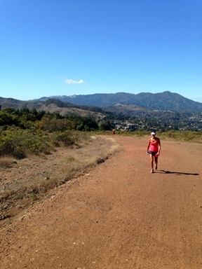
The trails in the Marin Headlands are a mix of dirt roads and singletrack, with elevations ranging from sea level to just over 1000'. While there are no large mountains within the Headlands, the area is still quite hilly so the trails have a good deal of climbing. The weather can be fickle in Marin. In the course of one day you may experience sun, wind, chilling fog, and driving rain. So it is always a good idea to bring along extra warm layers when exploring the Marin Headlands.
The trails in the Marin Headlands are a mix of dirt roads and singletrack, with elevations ranging from sea level to just over 1000'. While there are no large mountains within the Headlands, the area is still quite hilly so the trails have a good deal of climbing. The weather can be fickle in Marin. In the course of one day you may experience sun, wind, chilling fog, and driving rain. So it is always a good idea to bring along extra warm layers when exploring the Marin Headlands.
There are many trailheads in the Marin Headlands area. You can even start in San Francisco and run across the Golden Gate Bridge to access the Coastal Trail. All of the Favorite Runs on this page start from the Fort Cronkhite parking lot at the end of Mitchell Road._
The Dirt:
Extras:
The Dirt:
- Click here for a printable trail map of the Favorite Runs below.
- Click here for the official NPS web site.
- Click here for the official trail map of the Marin Headlands.
- Click here for the Parks Conservancy website.
- Click here for driving directions to the Fort Cronkhite parking lot at the end of Mitchell Road via Google Maps.
- Dogs are allowed on SOME trails; please refer to the official trail map for details. The Favorite Runs below include trails that are off-limits for dogs; therefore these routes are NOT dog-friendly. :(
Extras:
- There is no drinking water along the trails, so be sure to bring some with you.
- This is the location of several great trail races, including the North Face Endurance Challenge and Miwok 100k.
- The area is rich in Military history and offers several historical sites open to the public. Read the next section for more details...
Armor-Piercing Guns, Nike Missiles, and the Cold War
Starting as early as the 1890's, the Marin Headlands was the site of multiple military installations, designed to protect the Golden Gate from invasion by hostile ships. One such site is Battery Townsley. Completed in 1940, Battery Townsley featured two 16-inch caliber guns, each capable of shooting a 2,100 pound, armor-piercing projectile 25 miles out to sea. Today, this battery is open to the public and features a 16-inch naval gun, installed in 2012, that is similar to the original guns used at the battery.
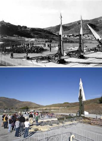 Site SF-88 at Fort Barry in 1959 (top) and today (bottom)
Later, the Marin Headlands became the site of a key Nike Missile installation. During the tense Cold War years from 1953 to 1979, the United States Army built and operated close to 300 Nike missile sites across the United States as the last line of defense against Soviet bombers. San Francisco was defended by 12 sites distributed around the Bay Area. All of the sites in the Bay Area were indicated by the prefix "SF-" followed by a number to indicate the exact site. Site SF-88 was located at Fort Barry in the Marin Headlands. It was opened in 1954 and then modified in 1958 to arm it with newer Nike Hercules missiles.
When the Army abandoned the launch area of SF-88 at Fort Barry in 1974, the National Park Service assumed custody of the site, incorporating it into the Golden Gate National Recreation Area. Today, a dedicated group of volunteers works with the Golden Gate National Recreation Area on the continuous task of restoration at site SF-88 which has been turned into a museum. This valuable historical resource is the only restored Nike missile site in the country open for public viewing. It's a great chance to see the tools of the Cold War up close.
Normal visiting days are Thursday-Saturday. A special tour with Nike veterans occurs on the first Saturday of each month. Restoration work to the site is done on remaining Saturdays by volunteers.
For a detailed history of the SF-88 site, check out the nikemissile.org website. For more information on visiting the restored SF-88 Nike missile site, refer to the NPS website.
Favorite Run #1: Tennessee Valley Loop (12.4 mi, ~2200' elevation gain)
|
This is a challenging loop with plenty of climbing. But, you are rewarded with great views of the ocean, the Marin hills, and the Golden Gate Bridge. The run starts with a tough climb up the Coastal Trail to Wolf Ridge. On the way you will pass several abandoned military sites including Battery Townsley. This first climb can be confusing because the route is a mix of dirt trails and old paved military roads, so be sure to follow the signs. The route then descends to Tennessee Valley followed by a climb up Marincello Trail and Slacker Hill for great views of San Francisco and the Golden Gate Bridge before a long descent back to your car. To start the run, continue past the gate at the end of Mitchell Road and turn left on the Coastal Trail.
GPX Track Printable Trail Map Driving Directions |
|
Route Details:
 The view from SCA Trail
- 0.0 mi: Continue up Mitchell Road past the gate, then turn left onto the narrow dirt Coastal Trail. You will follow the Coastal Trail for the next 1.7 miles as it varies between dirt trail and paved road.
- 0.3 mi: Turn left onto the road to continue on the Coastal Trail.
- 0.7 mi: Turn left at Battery Townsley and then an immediate right onto the dirt singletrack.
- 1.0 mi: The singletrack ends on a paved road. Turn right briefly and then left to continue climbing up the singletrack. When the trail intersects a dirt road, veer right to continue climbing up the road toward "Hill 88".
- 1.7 mi: Just before "Hill 88" veer left onto the dirt Wolf Ridge Trail and start descending.
- 2.5 mi: Wolf Ridge Trail ends on Miwok Trail. Turn left onto the Miwok Trail.
- 2.7 mi: Turn left onto the Old Springs Trail to descend to Tennessee Valley. Continue through the horse stables all of the way down to the trailhead on Tennessee Valley Road.
 Marincello Trail with Mt. Tam in the background
- 4.0 mi: At the Tennessee Valley Road trailhead. Just before Tenessee Valley Road, turn right to head up the Marincello Trail (fire road). This is a great 2-mile climb!
- 5.5 mi: Continue straight onto the Bobcat Trail (fire road).
- 6.3 mi: Quick jog left and then right onto the Alta Trail (fire road).
- 7.0 mi: Trail ends on Wolfback Road. Make an immediate right, then immediate left turn onto the singletrack SCA Trail. In about a mile you'll run very near the Hwy 101 tunnel with great views of the Golden Gate Bridge.
- 8.0 mi: Veer right onto the Coastal Trail towards McCullough Road.
- 8.3 mi: Turn left for a short detour to the top of Slacker Hill (0.2 miles one way). There are excellent views of San Francisco from the top! After enjoying the view, return to the Coastal Trail and continue in the direction you were heading.
- 9.0 mi: Cross McCullough Road, and continue on the Coastal Trail heading down towards Bunker Road.
- 10.6 mi: Trail ends on Bunker Road. Turn left and run along Bunker Road, but keep an eye out for a connector trail on your right.
- 10.7 mi: Turn right on the connector trail, then turn left onto the Rodeo Valley Trail.
- 11.1 mi: Turn left at Bobcat Trail and then left again at Miwok Trail. Stay on the fire roads.
- 11.6 mi: Miwok Trail ends at a dirt parking area. Continue straight ahead and run along Bunker Road.
- 12.0 mi: Veer left onto Mitchell Road and run along the side of the road back to your car.
- 12.4 mi: Back at your car!
Favorite Run #2: Pirates Cove Figure-8 (19.3 mi, ~3500 feet elevation gain)
|
This run is a longer version of Favorite Run #1, with an added loop that takes you past spectacular Pirates Cove. The run starts with a challenging climb up the Coastal Trail to Wolf Ridge, and a descent into Tennessee Valley. After Tennessee Valley, the route climbs up the Miwok Trail and then heads over to the coast for amazing views of the Pacific Ocean. You then return to Tennessee Valley to complete the climb up Marincello Trail and Slacker Hill, followed by a long descent to your car. This is a challenging route with a lot of climbing and no drinking water available, so plan accordingly! To start the run, continue past the gate at the end of Mitchell Road and turn left on the Coastal Trail.
GPX Track Printable Trail Map Driving Directions |
|
Route Details:
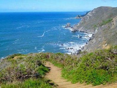 The spectacular Pirates Cove Trail
- 0.0 mi: Continue up Mitchell Road past the gate, then turn left onto the narrow dirt Coastal Trail. You will follow the Coastal Trail for the next 1.7 miles as it varies between dirt trail and paved road.
- 0.3 mi: Turn left onto the road to continue on the Coastal Trail.
- 0.7 mi: Turn left at Battery Townsley and then an immediate right onto the dirt singletrack.
- 1.0 mi: The singletrack ends on a paved road. Turn right briefly and then left to continue climbing up the singletrack. When the trail intersects a dirt road, veer right to continue climbing up the road toward "Hill 88".
- 1.7 mi: Just before "Hill 88" veer left onto the dirt Wolf Ridge Trail and start descending.
- 2.5 mi: Wolf Ridge Trail ends on Miwok Trail. Turn left onto the Miwok Trail.
- 2.7 mi: Turn left onto the Old Springs Trail to descend to Tennessee Valley. Continue through the horse stables all of the way down the dirt road to Tennessee Valley Road.
- 4.0 mi: At Tennessee Valley Road. Run across the dirt parking area and turn right, then look for the Miwok Trail heading off to the left of the road. Soon after, veer left to start climbing up the Miwok Trail.
- 5.3 mi: Just before you reach Marin Drive, turn left to continue on the Miwok Trail (Note: if you hit pavement you've gone too far!)
- 5.9 mi: Veer left onto the Coyote Ridge Trail, and stay on this trail until it ends.
- 6.6 mi: When Coyote Ridge Trail ends, turn right on Coastal Fire Road to Pirates Cove.
- 7.5 mi: When you reach the coast, turn left onto the narrow Coastal Trail. This singletrack follows the coastline for the next 1.5 miles with amazing views!
- 8.6 mi: Climb up the steps to continue on the Coastal Trail.
- 9.0 mi: The singletrack ends on the Coastal Fire Road. Veer right onto the Coastal Fire Road to head back to Tennessee Valley.
- 9.7 mi: Veer left onto Tennessee Valley Trail/Road to head back to the Tennessee Valley Trailhead. This trail will eventually turn into a paved road.
- 10.9 mi: Back at Tennessee Valley Trailhead. Just past the parking lot, turn right to head back toward the stables, then turn left onto the Marincello Trail (fire road). This is a great 2-mile climb!
- 12.4 mi: Continue straight onto the Bobcat Trail (fire road).
- 13.2 mi: Quick jog left and then right onto the Alta Trail (fire road).
- 13.9 mi: Trail ends on Wolfback Road. Make an immediate right, then immediate left turn onto the singletrack SCA Trail. In about a mile you'll run very near the Hwy 101 tunnel with great views of the Golden Gate Bridge.
- 14.9 mi: Veer right onto the Coastal Trail towards McCullough Road.
- 15.2 mi: Turn left for a short detour to the top of Slacker Hill (0.2 miles one way). There are excellent views of San Francisco from the top! After enjoying the view, return to the Coastal Trail and continue in the direction you were heading.
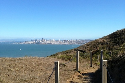 View of San Francisco from the Coastal Trail
- 15.9 mi: Cross McCullough Road, and continue on the Coastal Trail heading down towards Bunker Road.
- 17.5 mi: Trail ends on Bunker Road. Turn left and run along Bunker Road, but keep an eye out for a connector trail on your right.
- 17.6 mi: Turn right on the connector trail, then turn left onto the Rodeo Valley Trail.
- 18.0 mi: Turn left at Bobcat Trail and then left again at Miwok Trail. Stay on the fire roads.
- 18.5 mi: Miwok Trail ends at a dirt parking area. Continue straight ahead and run along Bunker Road.
- 18.9 mi: Veer left onto Mitchell Road and run along the side of the road back to your car.
- 19.3 mi: Back at your car!