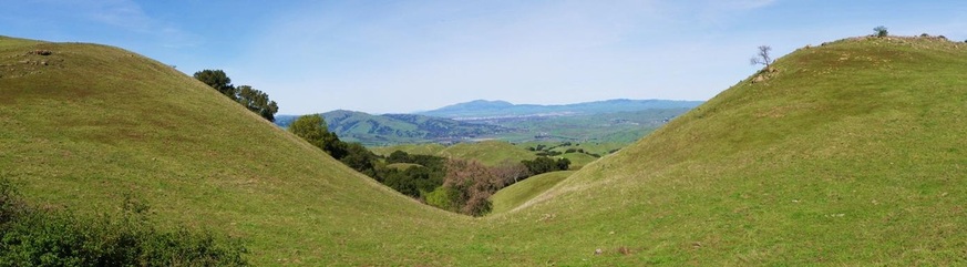
Mission Peak Regional Preserve
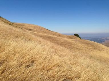
Mission Peak is a distinctive landmark that rises 2500' behind the city of Fremont. It is one of the best vista points in the East Bay and offers a 360-degree view from the summit. On a clear day, you can see from Silicon Valley all of the way to San Francisco to the west, and from Mount Diablo all of the way to Livermore to the east. Because of the amazing views and close proximity to an urban area, the summit is typically crowded on the weekends, despite the butt-kicking hike to get up there.
Mission Peak Regional Preserve offers about 15 miles of trails. The trails are mostly challenging fire roads, with a little singletrack thrown in. Most of the trails are steep and there is little shade, which means that a trip to the peak can be blisteringly hot in the summertime. So start early, wear sunscreen, and bring plenty of water.
There are two main trailheads for tackling Mission Peak. The main staging area is of Stanford Ave in Fremont. There is no charge to park here. The other trailhead is located at the back side of Ohlone College near the Aquatic Center. Starting from Ohlone College adds about a mile each way; however, the trail is less steep and there is at least a little shade. There is a small fee to park at Ohlone College. You can also reach Mission Peak by hiking through Ed Levin County Park in Milpitas.
The Dirt:
- Click here to download a printable trail map of the Favorite Runs below!
- Click here for the official park site with trail map.
- Click here for driving directions to the Stanford Ave staging area via Google Maps.
- Click here for driving directions to the Ohlone College trailhead via Google Maps ($4 parking fee as of 2015).
- Dogs are allowed, and may be off-leash away from trailheads, parking lots, and areas marked as on-leash only. Refer to the East Bay Regional Park page on Dogs for more information.
|
Extras:
|
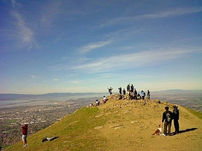
The view from Mission Peak Summit
|
Favorite Run #1: The Peak (7.4 mi, ~2200 feet elevation gain) 🐾
|
This run starts at the Ohlone College trailhead and takes you through the rolling East Bay hills all of the way to the summit of Mission Peak. The 360-degree view from the peak is spectacular on a clear day. The route is basically an out-and-back, with the addition of a small loop around the back side of the peak The trails are almost entirely fire roads which can be hot, sunny, and dry in the summer!
The run starts at the well-marked trailhead near the Aquatic Center in Ohlone College. To begin the run, head south from the parking lot to the Peak Trail. GPX Track Printable Trail Map Driving Directions |
|
Route Details:
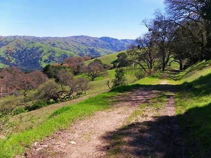
 The trail to Mission Peak
- 0.0 mi: Start heading up the Peak Trail (also marked as the Ysc Trail). You will follow the Peak Trail all of the way to the peak.
- 0.3 mi: Sharp right turn to stay on the Peak Trail
- 1.2 mi: Just past the small pond (dry in the summer) veer right onto the singletrack to stay on the Peak Trail.
- 1.9 mi: Turn right back onto the fire road to continue up the Peak Trail.
- 2.7 mi: Once the peak is in sight, veer left slightly (at marker 25) to continue up the steep, rocky Peak Trail. The trail follows the ridgeline up to the summit.
- 2.8 mi: Ohlone Wilderness Trail junction. Continue straight on the Peak Trail.
- 3.3 mi: At the summit! Enjoy the view, then continue along the Peak Trail (don't turn around).
- 3.6 mi: Junction with Horse Heaven & Eagle Loop Trails. Turn right and descend toward Horse Heaven Trail.
- 3.8 mi: Just before crossing the stream and the gate, turn right onto the badly marked Grove Trail. This trail follows the fence down and is often very muddy in the winter & spring.
- 4.2 mi: Continue onto the fire road/driveway near the park residence.
- 4.5 mi: Turn right onto the Ohlone Wilderness Trail. You will climb briefly back to the ridgeline.
- 4.7 mi: Veer left back onto the Peak Trail. Now retrace your steps back down the Peak Trail to Ohlone College.
- 7.4 mi: Back at the car!
Favorite Run #2: Sunol Out-and-Back (16.2 mi, ~3900 feet elevation gain) 🐾
|
This extremely challenging run combines the trip up to Mission Peak summit with a challenging out-and-back to Sunol Regional Wilderness via the Ohlone Wilderness Trail. After climbing up to the ridge, you run along the back side of the peak for gorgeous views of the Sunol Valley. You then descend almost 2000' down to Sunol Regional Wilderness headquarters. After a water break, you then turn around and head back up to the summit of Mission Peak, followed by a 2000' descent back to your car.
Please note that this a very hard run with lots of climbing, and it can be very hot in the summer! If you want to do a shorter version, you can do this as a 7.9-mile point-to-point run by arranging a pick-up at Sunol Regional Wilderness headquarters. GPX Track Printable Trail Map Driving Directions |
|
Route Details:
 Ohlone Wilderness Trail, overlooking Sunol Valley
- 0.0 mi: Start heading up the Peak Trail (also marked as the Ysc Trail). You will follow the Peak Trail most of the way to the peak.
- 0.3 mi: Sharp right turn to stay on the Peak Trail
- 1.2 mi: Just past the small pond (dry in the summer) veer right onto the singletrack to stay on the Peak Trail.
- 1.9 mi: Turn right back onto the fire road to continue up the Peak Trail.
- 2.7 mi: Once the peak is in sight, veer left slightly (at marker 25) to continue up the Peak Trail. Shortly after, veer left again onto the Eagle Trail, which is also the Ohlone Wilderness Trail. This trail will take you around the backside of the peak. You will follow the Ohlone Wilderness Trail all of the way down to Sunol Regional Wilderness.
- 3.4 mi: Turn left on Laurel Loop Trail to continue following the Ohlone Wilderness Trail. The next 5 miles is mostly flat or downhill on a dirt road.
- 7.0 mi: Head through the gate and cross over Calaveras Road. The trail now becomes singletrack. Continue downhill to Sunol Regional Wilderness Headquarters.
- 7.9 mi: (Water available) At Sunol Regional Wilderness. Head through the dirt parking lot to the bathrooms and drinking water. Fill up you bottles, take a breath, and then turn around and head back up the Ohlone Wilderness Trail! The next 5 miles is a very difficult climb! You will retrace your steps all of the way back up to Eagle Trail (at the back side of Mission Peak).
- 12.2 mi: Back at the Eagle Trail. This time, turn LEFT and continue climbing up the Eagle Trail around to the left side of the peak.
- 12.6 mi: Once you reach the ridgeline, turn right to head up to Mission Peak summit.
- 12.9 mi: At Mission Peak summit! Enjoy the view, and then continue straight ahead to descend from the peak along the ridgeline. Keep going straight ahead past the bathroom to continue down Peak Trail, back to your car.
- 16.2 mi: Back at Ohlone College and your car!
Classic East Bay Hills along the Ohlone Wilderness Trail