Palo Alto Baylands Preserve
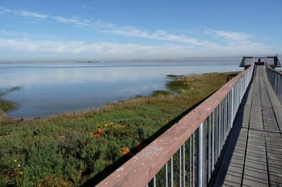
Just seconds off of busy Highway 101 at the San Antonio Ave exit, Palo Alto Baylands Preserve is the largest tract of undisturbed marshland remaining in the San Francisco Bay. It is a great place for a quick, flat run or hike on well-maintained roads and wide dirt trails extending out into the bay. Along the trails you will experience abundant wildlife, 360-degree views of the Bay Area, and, if the wind is right, that interesting "South Bay" smell!
The main trailhead and parking area is at the north end of San Antonio Ave. Just exit 101 and drive north on San Antonio until the road ends at the park.
The Dirt:
Extras:
The main trailhead and parking area is at the north end of San Antonio Ave. Just exit 101 and drive north on San Antonio until the road ends at the park.
The Dirt:
- Click here for a printable map of the Favorite Run below!
- Click here for the official web site with trail ma .
- Click here for driving directions to the San Antonio Ave trailhead via Google Maps.
- Dogs on leash are permitted on all trails in the preserve!
Extras:
- The Palo Alto Weekly holds an annual Moonlight Run here each fall. Bring your headlamp!
- There is a bathroom and drinking fountain located near the trailhead.
Favorite Run: Southern Loop (5.3 mi, ~0 feet elevation gain) 🐾
|
This loop encompasses most of the southern half of the preserve. The route takes you through Charleston Slough which is a temporary or permanent home to hundreds of different species of shore birds and waterfowl. The run is basically flat, and is about 25% paved trail and 75% dirt road/trail.
To start the run, head through the gate and up the paved trail past the bathrooms. GPX Track Printable Trail Map Driving Directions |
|
Route Details:
- 0.0 mi: Start up the paved Bay Trail past the bathrooms.
- 0.1 mi: Turn left on the paved trail toward East Bayshore Road
- 0.5 mi: At East Bayshore Road. Turn right on the paved trail and continue to follow the road. Continue on the trail past the large parking lots on the right. Check out the photovoltaic panels!
- 1.3 mi: Just past the wooden bridge, turn right on the wide dirt trail into the preserve. Continue all of the way around the landfill.
- 2.9 mi: At the T-junction, turn right. You will follow this trail all of the way back to your car. Look for the small singletrack trails along the right side that parallel the main trail.
- 5.2 mi: Continue straight ahead toward the parking area.
- 5.3 mi: Back at your car!