San Geronimo Trail Run
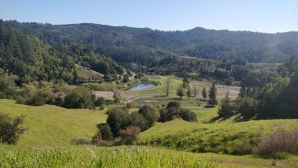
 Looking out onto San Geronimo
The city of San Gernomio sits quietly nestled in the middle of Marin County. Many drive by this town on the way to more exciting destinations like Point Reyes or the Mt. Tamalpais Watershed but the parks surrounding this small town has some fun running itself!
French Ranch, Maurice Thorner Memorial, and Roy's Redwoods are all owned and operated by Marin County Parks congaing steep fire roads and gentle single track. The park has dry summers and wet winters so expect the trails to be buffed out and hard during the dry months and sloppy and muddy when it rains.
While the parks themselves are fairly small, connecting them can result in some fun running! Running them as a figure eight and doing laps are great ways to increase distance in these cute little parks.
The Dirt:
- Click here (coming soon) to download a printable trail map of the Favorite Runs below!
- Click here for the official park site with trail map.
- Click here for driving directions to the trailhead via Google Maps.
- Parking of Nicasio Valley Road is free but may fill up on busy weekends.
- Dogs are allowed, and may be off-leash under voice command on fire roads. They are allowed on single track trails on-leash as well!
Extras:
- The park is open 24 hours, enjoy all the night running you would like!
- There is no potable drinking water available within the preserve.
Favorite Run #1 The Three Park Shuffle (4.8 mi, ~800 feet elevation gain) 🐾
|
This run starts off of Nicasio Valley Road. Looping through three parks this run sees a small redwood grove, steep fire roads, and some pretty views of San Geronmo.
Parking is only allowed on the eastern end of the road. Start at the gate on the eastern end near the map and head left onto the single track to the left of the meadow. GPX Track Printable Trail Map (coming soon) Driving Directions |
|
Route Details:
 A view out from Top Flight Trail.
- 0.0 mi: Go past the gate to the fire road and veer left onto the single track to the left of the meadow.
- 0.1 mi: You will be dumped out onto a fire road, continue to the right. Continue for a second and take a right onto Roy's Redwoods Loop Trail.
- 0.5 mi: The trail intersects with Meadow Trail, take a left and continue on Roy's Redwoods Loop Trail and begin to climb a little bit.
- 0.6 mi: You will reach a four way intersection, continue straight and begin to descend towards the redwoods! Enjoy the shade as once you leave it you will not really get it back.
- 1.5 mi: The descent has ended and you will pass a trail on your left. Continue onward heading west parallel with Sir Francis Drake Road. You will pass over a couple bridges over the next mile.
- 2.1 mi: You will see a pedestrian bridge straight ahead crossing over Nicasio Valley Road. Cross the bridge and take an immediate left on the other side onto Thorner Ridge Trail where you will start a short climb.
- 2.8 mi: As you descend the switchbacks on Thorner Ridge Trail you will eventually leave the trees. The trail will dump you onto Lagunitas School Road. Continue to follow Lagunitas School road towards Sir Francis Drake Blvd. Stay on the road even though there are enticing trails on the right, they will lead you elsewhere.
- 3.2 mi: Once you see Sir Francis drake in sight, there is a small trail called School Trail on the right. Take the right onto it.
- 3.4 mi: Take a right onto Top Flight Trail. The trail sign will be around 20 or so yards into running up Top Flight Trail. The trail will wind in between some homes and fences. It starts gentle and begins to kick up near the end. Stay on the trail itself and do not veer through the fences on the right side as they lead elsewhere.
- 3.5 mi: Top Flight Trail starts to get very steep! If you are hurting you are going the right way!
- 3.6 mi: The steep climbing will end for you, take a right to continue on Top Flight Trail. It is almost a u-turn!
- 4.2 mi: After winding in and out on Top Flight Trail, continue onward to Meadow Road. This paved road will take you back to the trailhead.
- 4.8 mi: Take a left onto Nicasio Valley Road and you will immediately reach the trailhead.