Sanborn County Park
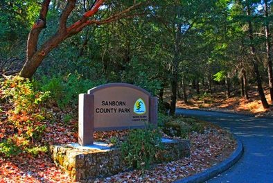
Sanborn County Park is a lushly wooded park of over 3,688 acres, nestled in the Santa Cruz Mountains between Saratoga and Skyline Boulevard. This mountain park offers over 15 miles of trails through redwoods and tan bark oak, in addition to a well-developed picnic area and walk-in campground with over 30 sites.
The trails in the park are mostly challenging singletrack, with the exception of the lower trails through the campground areas which are dirt roads or paved trails. Elevations in the park range from about 1400 feet at the park entrance to about 3000 feet at the summit of Sunnyvale Mountain along Skyline Blvd. The trails are entirely shaded, which means that this is a great place to come in the summer when the weather is hot. Because of the dense forest, there are no scenic viewpoints along the trails; however, the redwood forests are quite beautiful and more than make up for the lack of panoramic vistas.
All of the runs on this page start from the main park entrance area off of Sanborn Road.
The Dirt:
Extras:
The trails in the park are mostly challenging singletrack, with the exception of the lower trails through the campground areas which are dirt roads or paved trails. Elevations in the park range from about 1400 feet at the park entrance to about 3000 feet at the summit of Sunnyvale Mountain along Skyline Blvd. The trails are entirely shaded, which means that this is a great place to come in the summer when the weather is hot. Because of the dense forest, there are no scenic viewpoints along the trails; however, the redwood forests are quite beautiful and more than make up for the lack of panoramic vistas.
All of the runs on this page start from the main park entrance area off of Sanborn Road.
The Dirt:
- Click here to download a printable map of the Favorite Runs below!
- Click here for the Sanborn County Park website with a link to the trail map.
- Click here for driving directions to the trailhead via Google maps.
- Dogs on leash are allowed on ALL TRAILS in the park!
Extras:
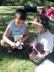
- Sanborn County Park is home to the Youth Science Institute (YSI) and the Shady Shakespeare theater company. See the next section for more details.
- The only drinking water available in the park is near the trailhead by the visitor center.
The Arts and Science in Sanborn County Park
In addition to miles of trails and spectacular redwood forests, Sanborn County Park offers a range of activities for the whole family...
- During the summer months, Sanborn County Park is home to the only outdoor Shakespearean company in Silicon Valley. Since 1999, Shady Shakespeare (now Silicon Valley Shakespeare) has been delighting audiences with outstanding productions of the works of Williams Shakespeare.
- Youth Science Institute (YSI), a 501(c)3 not-for-profit organization, operates one of their sites in Sanborn County Park. Since their founding in 1953, YSI has become a Silicon Valley leader in nature-based science education, teaching physical, earth, life and social sciences to pre-school through 8th-grade students throughout Santa Clara County and Silicon Valley. YSI school programs, after-school programs, and summer science camps address the science education crisis and fill the gap in classroom science education to inspire enthusiasm for science and love of learning. For more information, please visit www.ysi-ca.org.
Favorite Run #1: San Andreas/Sanborn Loop (4.1 mi, ~1300 feet elevation gain) 🐾
|
This run takes you up the endless switchbacks on the San Andreas Trail and back down the narrow Sanborn Trail. Even though this run is only about 4 miles, it is still a real butt-kicker with over 1300 feet of elevation gain in only 1.5 miles. However, you are rewarded with a nice technical downhill through beautiful forest. There are a few tricky trail intersections on this route, so we recommend you carry a map or download the route as a GPX track.
Start this run by heading past the pond toward the Nature Trail. Follow signs to the San Andreas Trail. GPX Track Printable Trail Map Driving Directions |
|
Route Details:
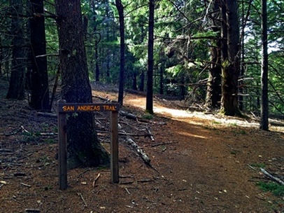 Climbing the San Andreas Trail
- 0.0 mi: From the parking lot, head past the gate and veer slightly right to head around the pond. Follow signs to the Nature Trail and San Andreas Trail. There will be a few different trail junctions, but just keep following signs for the San Andreas Trail, which is basically a dirt road for the first half-mile.
- 0.3 mi: Confusing intersection!! Next to some huge old cement pipe is a "San Andreas Trail" sign with arrows pointing both left and right!! Turn right to continue on the San Andreas Trail! The trail will soon become a singletrack and really start climbing!
- 2.1 mi: San Andreas Trail ends on Sanborn Trail. Make a sharp left turn onto Sanborn Trail. You will climb briefly and then start descending.
- 3.1 mi: The singletrack comes out onto a dirt road, which splits in two directions. You can go in either direction because the two roads converge in another 0.1-mile.
- 3.3 mi: Junction with Peterson Memorial Trail. Stay right to continue down the Sanborn Trail service road. The road will soon become paved as it passes through the campground. Continue through the campground back to the parking lot and your car.
- 4.1 mi: Back at your car!
Favorite Run #2: Sunnyvale Mountain Climb (8.1 mi, ~2000 feet elevation gain) 🐾
|
So you've never heard of Sunnyvale Mountain? Well, it's actually more of a "high spot" than a peak, with the dense forest blocking any views. However, this trip is about the journey, not the destination, because the upper part of the Sanborn Trail passes through the beautiful Todd Creek Redwood Grove before intersecting with the rolling Skyline Trail. A strange point of interest on this run is the odd "cement tree" at Sunnyvale Mountain. This was a hollow tree that was filled with cement for some reason. It's hard to explain until you see it... There are a few tricky trail intersections on this route, so we recommend you carry a map or download the route as a GPX track.
Start this run by heading past the pond toward the Nature Trail. Follow signs to the San Andreas Trail. GPX Track Printable Trail Map Driving Directions |
|
Route Details:
|
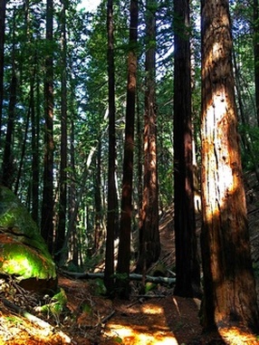
Todd Creek Redwood Grove
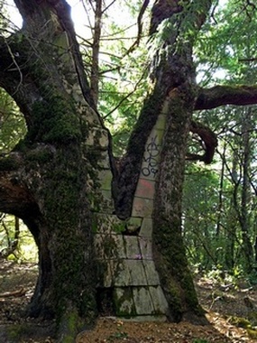
The odd "cement tree" at Sunnyvale Mtn
|
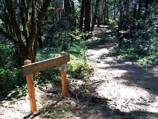
Favorite Run #3: John Nicholas Loop (8.6 mi, ~1800 feet elevation gain) 🐾
|
The John Nicholas Trail in Sanborn County Park was opened in November 2014. This new 3.4-mile trail connects Skyline Trail to Sanborn Road, and from there it's just a half-mile to the park entrance. In addition to the trail being fun and well-maintained, it also offers a spectacular viewpoint with a redwood bench. The first half of this route is identical to Favorite Run #2 until you branch off onto the John Nicholas Trail for a swooping 3-mile descent. Note that bikes are allowed on the John Nicholas Trail so keep an eye out for them. There are a few tricky trail intersections on this route, so we recommend you carry a map or download the route as a GPX track.
Start this run by heading past the pond toward the Nature Trail. Follow signs to the San Andreas Trail. GPX Track Printable Trail Map Driving Directions |
|
|
Route Details:
|
The start of the John Nicholas Trail

View from John Nicholas Trail
|