Sugarloaf Ridge State Park
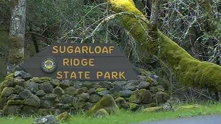
Sugarloaf Ridge State Park is a 4,020-acre park situated in the Mayacamas Mountains between the Sonoma and Napa valleys, about ten miles north of Sonoma. The area got its name from the shape of the ridge at its southern edge. In the 1800's, sugar was molded into cone shaped loaves and many hills and mountains with a conical shape were therefore called “sugarloaf.” The centerpiece of Sugarloaf Ridge is 2,729' Bald Mountain, which offers views of Napa Valley, Sonoma Valley, and Mount Saint Helena. On clear days it is even possible to see the Golden Gate Bridge and the Sierra Nevada mountains. There is also a 25' waterfall that flows seasonally along Sonoma Creek. Sugarloaf Ridge was one of the first parks to close due to budget cuts; however, in 2012 the park was reopened by Team Sugarloaf who restored access to camping and hiking trails.
The park offers 25 miles of trails, which are a mix of dirt roads and singletrack. The trails are well marked and maintained but are rugged and rough in sections. Elevations in the park range from 600 feet at the entrance to 2,729 feet at the top of Bald Mountain.
In addition to challenging hiking trails, Sugarloaf Ridge State Park also offers activities for the whole family, including concerts, camps, and guided hiking tours. It is also the home to the Robert Ferguson Observatory, the largest observatory in the western United States completely dedicated to public viewing and education. Refer to the website for upcoming events. The park also offers the PlanetWalk, a scale model of the solar system designed to fit within the boundaries of Sugarloaf Ridge State Park. Starting from the Sun, which is located near the observatory, the walk follows the Brushy Peaks Trail past all of the planets in their proper relative distances until you reach Pluto, about 2.5 miles away.
There are a few different trailheads in the park. The Favorite Runs on this page start from the first parking lot, about 500 feet past the entrance kiosk on the left side of the road.
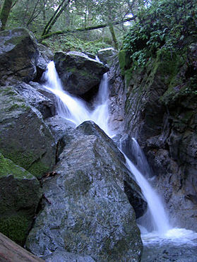 Waterfall along Sonoma Creek
The Dirt:
Extras:
- Click here to download a printable trail map of the Favorite Run below!
- Click here for the Sugarloaf Ridge State Park website, with link to park brochure.
- Visit the Team Sugarloaf website for updated park information, calendar of events, and camping information.
- Click here for driving directions to the trailhead parking area via Google Maps.
- Dogs are not allowed on trails in the park.
Extras:
- Sugarloaf Ridge State Park also offers activities for the whole family, including concerts, camps, and guided hiking tours. Check the Team Sugarloaf page for the current calendar of events.
- It is also the home to the Robert Ferguson Observatory, the largest observatory in the western United States completely dedicated to public viewing and education.
- There is no drinking water available in the park, and it can get very hot on the summer, so bring plenty of water!
Favorite Run #1: Bald Mountain Loop (7.9 mi, ~1600' elevation gain)
|
This route is the grand tour of Sugarloaf Ridge State Park. From the parking lot, the route first climbs over 1,400 feet in about 2.5 miles to reach the summit of Bald Mountain. The next couple of miles are rolling along the ridge, where you will enjoy great views of the surrounding valleys below. The final few miles are a long singletrack descent, following the PlanetWalk backwards from Pluto to the Sun. Note that there is almost no shade on this loop, so wear sunscreen and bring plenty of water!
This run starts from the first parking lot. After passing the entrance kiosk, drive about 500 feet and you will see the parking on your left. Start the route by heading up the Lower Bald Mountain Trail. GPX Track Printable Trail Map Driving Directions |
|
Route Details:
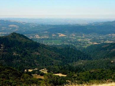 View of Sonoma Valley from Bald Mountain
- 0.0 mi: From the parking area, start up the Lower Bald Mountain Trail toward Bald Mountain Trail.
- 0.3 mi: At the fork, stay left to continue climbing on the Lower Bald Mountain Trail.
- 0.8 mi: Lower Bald Mountain Trail ends at Bald Mountain Trail, which is a dirt road. Turn right and continue climbing.
- 2.2 mi: Pass the road to the radio tower on your left. Stay right to continue climbing toward Bald Mountain summit.
- 2.6 mi: At Bald Mountain summit! Enjoy the view, then get onto the Grey Pine Trail, which is also a dirt road. (Note: do not get onto the High Ridge Trail by accident!) The trail will descend for the next mile.
- 3.6 mi: Just after a short climb, you will hit an unmarked trail junction. Stay right to continue on the Grey Pine Trail.
- 3.7 mi: Turn left onto the Brushy Peaks Trail. (Note: This is a singletrack trail.)
- 4.8 mi: The trail forks, but you can take either fork because they meet up in another tenth of a mile.
- 4.9 mi: Pass Pluto. The trail forks again, and again you can take either fork.
- 5.4 mi: Pass Neptune.
- 6.6 mi: Just past Uranus, turn right onto the Meadow Trail to continue following the PlanetWalk. Over the next mile you will pass Saturn, Jupiter, and Mars.
- 7.5 mi: Trail ends at the observatory. Check out Earth, then turn left and head through the parking lot past Venus, Mercury, and the Sun. Then continue down Adobe Canyon Road back to your car.
- 7.9 mi: Back at the parking lot and your car!