Alum Rock Park and Sierra Vista Open Space Preserve
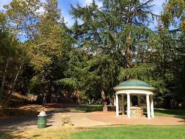
Established in 1872, the 740-acre Alum Rock Park is one of California's oldest municipal parks. The park, named for a giant boulder that was once thought to be aluminum, is nestled within the Penitencia Creek Canyon in the foothills of the Diablo Range just east of San Jose. From 1890 through 1932 the park was a nationally known health spa with 27 mineral springs, including sulfur, magnesia, iron, and naturally carbonated soda springs. In addition, the park contained an indoor swimming pool, tea garden, restaurant, and dance pavilion. At that time you could ride from downtown San Jose to the park on the Alum Rock Steam Railroad for a quarter. People flocked to the park from around the country to soak in the park’s warm mineral waters, which many claimed had medicinal benefits. Some Sundays, as many as 10,000 visitors would swarm the park's hillsides and hot pools.
The park had so many visitors that, by the early 1970's, the native plants and animals were nearly overrun. In response, San Jose decided to return Alum Rock Park back to a more natural state. The city demolished the pool, removed many of the buildings, and closed some areas of the park. Today, remnants of the railroad bridges and some of the stone grottos built around the mineral springs remain as reminders of the park's past.
The park had so many visitors that, by the early 1970's, the native plants and animals were nearly overrun. In response, San Jose decided to return Alum Rock Park back to a more natural state. The city demolished the pool, removed many of the buildings, and closed some areas of the park. Today, remnants of the railroad bridges and some of the stone grottos built around the mineral springs remain as reminders of the park's past.
 The Sierra Vista Trail
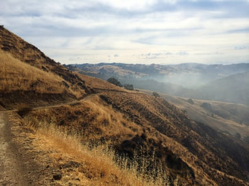
Sierra Vista Open Space Preserve, accessible only through Alum Rock Park, comprises about 1,700 acres of grassland in the steep hills above Penitencia Creek Canyon. The two parks combined offer approximately 23 miles of varied trails for all abilities. Alum Rock Park offers more moderate trails, such as the gentle Penitencia Creek Trail. Sierra Vista offers more challenging trails. The Boccardo Loop Trail, for example, climbs almost 1000' in only 1.5 miles! Elevations in the two parks range from around 300' at the Alum Rock Park entrance to 2000' at the eastern side of Sierra Vista. The trails are a mix of dirt road and singletrack. Alum Rock Park is generally shaded, while the trails in Sierra Vista are sunny and exposed, so don't forget your sunscreen!
In addition to hiking and running, Alum Rock park offers multiple picnic sites with tables, barbecue pits, water, and restrooms. There are lawns and a children's playground in the mid-canyon area. Also, mountain biking is allowed on many of the trails. Refer to the official trail map for details on which trails are open for bikes.
In addition to hiking and running, Alum Rock park offers multiple picnic sites with tables, barbecue pits, water, and restrooms. There are lawns and a children's playground in the mid-canyon area. Also, mountain biking is allowed on many of the trails. Refer to the official trail map for details on which trails are open for bikes.
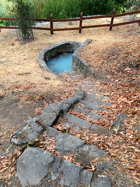 One of the remaining mineral baths
The Dirt:
Extras:
- Click here to download a printable trail map of the Favorite Runs below!
- Click here for the Alum Rock Park website with link to trail map.
- Click here for the Sierra Vista Open Space Preserve website with link to trail map.
- Click here for driving directions to the Penitencia Creek Trailhead parking lot via Google Maps. As of August 2014, there is no fee to park in this lot, which is just before the entrance kiosk. However, there is a fee to park anywhere inside the park after the kiosk.
- Note that Sierra Vista Open Space Preserve is accessible only through Alum Rock Park.
- Dogs are NOT ALLOWED in the park.
Extras:
- In addition to hiking trails, the park offers multiple picnic sites with tables, barbecue pits, water, and restrooms.
- Alum Rock Park is home to the Youth Science Institute (YSI) Alum Rock Science and Nature Center. Refer to the next section for details.
- Mountain bikes are allowed on many of the trails (refer to trail map for details).
- There is drinking water available at most of the picnic areas in the canyon.
Youth Science Institute in Alum Rock Park
In addition to miles of challenging trails, Alum Rock Park is home to the Youth Science Institute (YSI) Alum Rock Science and Nature Center. The Science and Nature Center has exhibits of animals that populate the nearby Mount Hamilton Range. There is an exhibit of taxidermy birds that is sectioned off into owls, hawks, sea birds, and waterfowl. Animal remains are set up throughout the center and labeled accordingly. There is a separate room for live animals that are kept in their designated space along with a brief description of each animal. Occasionally, there is a pair of owls that roam free within the room.
Founded in Alum Rock Park in 1953, YSI provides year-round school and public programs and interpretive services in the Park, thanks to a long-term partnership with the City of San Jose. YSI is a 501(c)3 non-profit organization that partners with nature to teach science to 33,000 pre-school through 12th grade students throughout Silicon Valley each year. YSI school programs, after-school programs, and summer camps fill the gap that is present in science education today to inspire in students enthusiasm for science and love of learning, to develop the critical thinking skills they need for academic success, and to forge connections with nature that foster their personal health and earth stewardship. YSI has two additional Science and Nature Centers at Sanborn Park in Saratoga and Vasona Lake Park in Los Gatos. For more information, please visit www.ysi-ca.org.
Founded in Alum Rock Park in 1953, YSI provides year-round school and public programs and interpretive services in the Park, thanks to a long-term partnership with the City of San Jose. YSI is a 501(c)3 non-profit organization that partners with nature to teach science to 33,000 pre-school through 12th grade students throughout Silicon Valley each year. YSI school programs, after-school programs, and summer camps fill the gap that is present in science education today to inspire in students enthusiasm for science and love of learning, to develop the critical thinking skills they need for academic success, and to forge connections with nature that foster their personal health and earth stewardship. YSI has two additional Science and Nature Centers at Sanborn Park in Saratoga and Vasona Lake Park in Los Gatos. For more information, please visit www.ysi-ca.org.
Favorite Run #1: Mineral Springs Loop (7.1 mi, ~1000’ elevation gain)
|
This loop is a great tour of Alum Rock Park, from the bottom of the Penitencia Creek Canyon up to the high point along South Rim. The first two miles of this loop are a gradual climb along the Penitencia Creek Trail. After passing through the sulfur-smelling Mineral Springs area, the trail narrows as it climbs more steeply up a series of switchbacks to the South Rim. The trail then rolls along the ridge before it descends back to the Penitencia Creek Trail which takes you back to the start.
The run starts from the Penitencia Creek Trailhead. As of August 2014, it is free to park in this lot. To begin the run, start up the well-marked Penitencia Creek Trail. GPX Track Printable Trail Map Driving Directions |
|
Route Details:
|
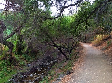
Penitencia Creek Trail
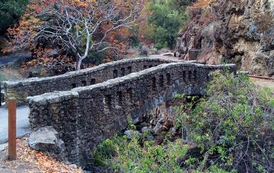
Old stone bridge near the mineral springs
|
Favorite Run #2: Bull Dozier Loop (13.9 mi, ~2600' elevation gain)
|
This is a challenging loop that takes you on a grand tour of both parks. The run is tough from the start, climbing almost 1700' in the first 4 miles. However, after the initial climb you are immediately rewarded with a trip along the Sierra Vista Trail. Completed in 2011, the Sierra Vista Trail precariously hugs the steep slopes above the Penitencia Creek Canyon for 1.3 miles, offering stunning views of the hills to the east, the Monterey Peninsula to the south, and silicon valley to the west. The Sierra Vista Trail ends at a fire road which, after a brief climb, descends about 800' to Alum Rock Falls Road, a paved road that takes you down Penitencia Creek Canyon to the Mineral Springs Area. After passing through the sulfur-smelling Mineral Springs area, the trail narrows as it climbs more steeply up a series of switchbacks to the South Rim. The trail then rolls along the ridge before it descends back to the Penitencia Creek Trail which takes you back to the start.
The run starts from the Penitencia Creek Trailhead. As of August 2014, it is free to park in this lot. To begin the run, start up the well-marked Penitencia Creek Trail. |
|
Special thanks to Kent Dozier for suggesting this run!
DISCLAIMER: The 1.4-mile section of Alum Rock Falls Road between lower Calaveras Fault Trail and the Mineral Springs area is private and marked "No Trespassing." Travel this section at your own risk! (Unfortunately, this road is the only way to form a large loop in the Sierra Vista OSP.)
DISCLAIMER: The 1.4-mile section of Alum Rock Falls Road between lower Calaveras Fault Trail and the Mineral Springs area is private and marked "No Trespassing." Travel this section at your own risk! (Unfortunately, this road is the only way to form a large loop in the Sierra Vista OSP.)
Route Details:
|
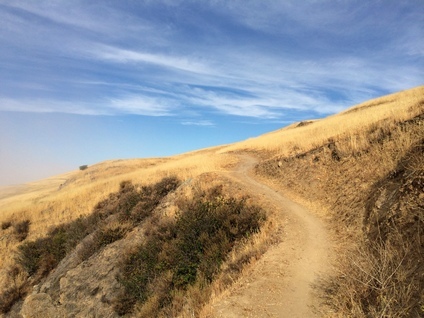
The Sierra Vista Trail
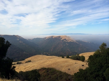
Views from Sierra Vista OSP
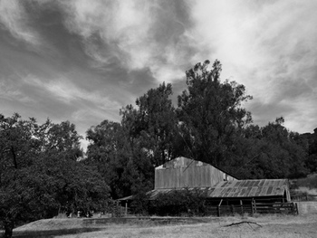
Old barn at the back of Sierra Vista OSP
|
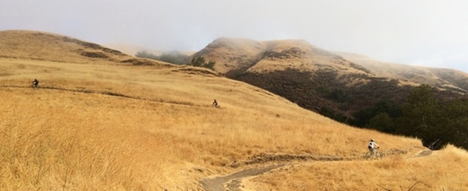
Mountain bikers tackling the switchbacks on the Boccardo Loop Trail