Forest of Nisene Marks State Park
When you explore the beautiful, dense forest at Forest of Nisene Marks State Park, it is hard to believe that this land was clear-cut in the early 1900's by the Loma Prieta Lumber Company. Today, the forest has regrown and is preserved as a spectacular State Park. The park is named for Nisene Marks, a nature lover and mother of the Salinas farming family that purchased the land in the hopes of finding oil. After drilling efforts failed to find any oil, Marks' children donated the 9,700 acres of land in her memory to the state of California in 1963. The California State Parks department later expanded the park to 10,036 acres. Today the park is a popular spot for running, hiking and horseback riding.
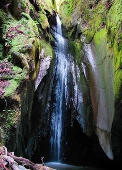
Unfortunately the Forest of Nisene Marks State Park was made famous when, at 5:04 pm on October 17, 1989, the magnitude 6.9 Loma Prieta earthquake struck northern California, killing 63 people. The epicenter of the quake was located in this park along Aptos Creek, and can be accessed today via the narrow Aptos Creek Trail. In early 2007, there was landslide on the trail, and the trail was closed. However, in 2013 the trail was repaired and a new bridge was added. In addition to the epicenter, this trail allows access to the popular Five Finger Falls.
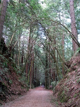
The Forest of Nisene Marks State Park contains over 40 miles of trails that are a 50/50 mix of old logging roads and singletrack. Elevations in the park range from sea level to more than 2,600 feet. In addition to hiking and running, the park offers picnic tables and barbecue pits, as well as a trail camp located near Sand Point, about 6 miles from the parking lot.
Unfortunately the Forest of Nisene Marks State Park was made famous when, at 5:04 pm on October 17, 1989, the magnitude 6.9 Loma Prieta earthquake struck northern California, killing 63 people. The epicenter of the quake was located in this park along Aptos Creek, and can be accessed today via the narrow Aptos Creek Trail. In early 2007, there was landslide on the trail, and the trail was closed. However, in 2013 the trail was repaired and a new bridge was added. In addition to the epicenter, this trail allows access to the popular Five Finger Falls.
The Forest of Nisene Marks State Park contains over 40 miles of trails that are a 50/50 mix of old logging roads and singletrack. Elevations in the park range from sea level to more than 2,600 feet. In addition to hiking and running, the park offers picnic tables and barbecue pits, as well as a trail camp located near Sand Point, about 6 miles from the parking lot.
 Five Finger Falls
All of the runs on this page start from the parking lot at George's Picnic Area, located about 1.1 miles past the entrance station. George's Picnic Area is just before the Steel Bridge and the "Winter Gate" which is locked during the winter. To access this parking lot, you have to pay a fee at the Entrance Station. For a longer run and to avoid the fee, you can park in the lot at the corner of Soquel Dr and Aptos Creek Road. This will add an additional 1.9 miles each way to the run.
The Dirt:
Extras:
The Dirt:
- Click here for a printable trail map of the Favorite Runs below!
- Click here for the official park website.
- Click here for driving directions via Google Maps to George's Picnic Area.
- Nisene Marks is a hot spot for poison oak. Click here to learn about preventing and treating poison oak rashes.
- Dogs on leash are allowed ONLY on Aptos Creek Fire Road and the following multi-use trails: Aptos Rancho Trail, Split Stuff Trail, Terrace Trail, and Vienna Woods Trail. Due to these restrictions, the Favorite Runs described below are not dog friendly. :(
Extras:
- The park also offers picnic tables and barbecue pits, as well as a trail camp located near Sand Point, about 6 miles from the parking lot.
- There is NO drinking water available in the park (even at the trail camp) so bring your own!
- Note that the narrow Aptos Creek Trail, which is part of Favorite Run #2 below, is sometimes closed due to landslide. Contact the park for more details.
Favorite Run #1: Sand Point big loop (13.0 mi, ~2000 feet elevation gain)
|
This loop covers a significant portion of the park. On the climb up Aptos Creek Fire Road, you'll pass the Bottom/Top-of-the-Incline that marks the site of a narrow-gauge railway once used to transport timber. At 1600' you'll reach the high point of the run, Sand Point, which provides great ocean views on a clear day. This is followed by a narrow, rolling singletrack downhill on the West Ridge Trail.
Important note: When running down the West Ridge trail, you will encounter a few unmarked trail junctions. But, keep following the most worn trail and you will be fine. Start the run by heading up the Aptos Creek Fire Road from George's Picnic Area, about 1.1 miles past the entrance station. GPX Track Printable Trail Map Driving Directions |
|
Route Details:
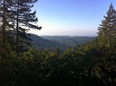 The view from Sand Point
- 0.0 mi: Start heading up the Aptos Creek Fire Road. You will stay on the Fire Road for the next 6.9 miles.
- 1.3 mi: Cross Margaret's Bridge.
- 2.7 mi: Bottom of the Incline. The climb gets steeper.
- 3.9 mi: Top of the Incline. The rest of the climb is very gradual.
- 6.9 mi: Sand Point Overlook. Stop and admire the view, then veer left onto Hinckley Basin Fire Road.
- 7.3 mi: Just before the West Ridge Trail Camp, turn left onto West Ridge Trail (Update 1/14/10: The trail sign is missing! But West Ridge Trail is the first singletrack you come to, and it's marked with a "no bikes" sign, so you can't miss it). You will stay on West Ridge Trail all of the way back down to the Aptos Creek Fire Road. The West Ridge Trail first climbs a bit, then is mostly downhill with a few brief uphill sections.
- 8.5 mi: Pass Big Stump Gap Trail on your left. Continue on West Ridge Trail.
- 9.0 mi: Pass Ridge Connection Trail on your left. Continue on West Ridge Trail.
- 12.6 mi: West Ridge Trail ends on Aptos Creek Fire Road. Turn right onto Aptos Creek Fire Road to head back to your car.
- 13.0 mi: Back at your car!
Favorite Run #2: Sand Point BIGGER loop (14.5 mi, ~2100 feet elevation gain)
|
WARNING: As of 2017, Aptos Creek Trail has been closed due to landslides. It is currently impassible beyond the epicenter. This run will remain here for posterity's sake.
This loop is a slightly modified version of Favorite Run #1. For this run you bypass the Bottom-of-the-Incline/Top-of-the-Incline portion of the Aptos Creek Fire Road and instead detour onto the Aptos Creek Trail and Big Slide Trail. The Aptos Creek Trail was previously closed due to a landslide; however, in 2013 a new footbridge was installed and the trail was reopened. This narrow singletrack trail passes the site of the 1989 Loma Prieta earthquake. Also, if you want to add some distance, this trail allows access to the 1.6-mile out-and-back trip to Five Finger Falls. After eight miles of almost continuous climbing you'll reach the high point of the run, Sand Point, which provides great ocean views on a clear day. This is followed by a fun, rolling singletrack downhill on the West Ridge Trail. Important note: When running down the West Ridge trail, you will encounter a few unmarked trail junctions. But, keep follow the most worn trail and you will be fine. |
|
Start the run by heading up the Aptos Creek Fire Road from George's Picnic Area, about 1.1 miles past the entrance station.
GPX Track
Printable Trail Map
Driving Directions
GPX Track
Printable Trail Map
Driving Directions
Route Details:
|
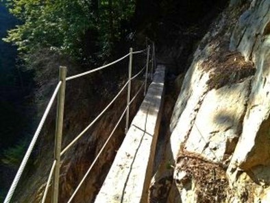
New footbridge on Aptos Creek Trail
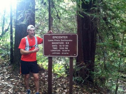
At the epicenter along Aptos Creek Trail
|