Fremont Older Open Space Preserve (and lower Stevens Creek County Park)
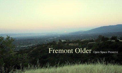
Fremont Older Open Space Preserve is a 739-acre preserve located in the hills above Stevens Creek Reservoir, overlooking the cities of Cupertino and Saratoga. The park is easily accessible, located only minutes from the urban area. Interesting features of the preserve include the open hayfields, Seven Springs Canyon, and Hunters Point, a 900-foot hilltop offering sweeping views of the Santa Clara Valley. To the west are chaparral and oak covered ridges dropping steeply to Stevens Canyon.
Fremont Older Open Space Preserve adjoins lower Stevens Creek County Park and Parker Ranch Trails, which combined boast about 20 miles of trails. The trails are primarily fire roads, although there are a few excellent singletrack trails in Fremont Older including Seven Springs Loop, the Toyon Trail, the Tony Look Trail, and the challenging Lookout Trail. Elevations in the park range from about 400' near the Stevens Creek Reservoir to about 1100' at Maisie's Peak. The climbs range from moderate to fairly difficult, the most challenging being the climb up from the reservoir on Coyote Ridge Trail which gains 500' in just under a mile.
Given the small size of the preserve, it is difficult to do very long runs in Fremont Older. However, there are a variety of nice shorter loops (less than 10 miles) than can be done. There is little shade in the park, and in the summer the preserve can get quite hot so bring water and a hat. Winter brings a nice respite from the heat; however, after a heavy rain the trails can be very loose and muddy so you may want to avoid Fremont Older right after a winter storm.
There are two main parking areas from which to access the trails of Fremont Older Open Space Preserve. The closest parking area to Cupertino is the Stevens Creek County Park north parking lot off of Stevens Canyon Road. From the Saratoga side, the closest parking area is at the west end of Prospect Road. All of the runs on this page start from the Stevens Creek County Park north parking lot.
The Dirt:
- Click here to download a printable trail map of the Favorite Runs below!!!
- Click here for the official web site with a good trail map.
- Click here for driving directions to the Stevens Creek County Park north parking area via Google Maps (there is a fee to park in this lot).
- Click here for driving directions to the Prospect Road parking area via Google Maps (parking is free.)
- Dogs on leash are allowed on ALL TRAILS in the preserve!
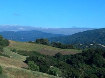 Cooper-Garrod Vineyards, viewed from Fremont Older
Extras:
- There is no water available in the preserve. Bring your own, and remember it can get very hot and dry in the summer!
- The trails are usually very muddy and slimy after a rain, so it's best to avoid the preserve after heavy winter rains.
- The south side of Fremont Older Open Space Preserve adjoins Cooper-Garrod Estate Vineyards, which offers tastings and special events. This is located next to Garrod Farms, which offers guided horseback tours through Fremont Older Preserve (in case you were wondering where all the poop came from).
- Fremont Older Open Space Preserve adjoins lower Stevens Creek County Park and Parker Ranch Trails, which can be combined to create longer routes.
The Fremont Older House (a dollar-per-year lease agreement)
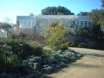 The Fremont and Cora Older House
Fremont Older Open Space Preserve gets its name from San Francisco newspaper editor Fremont Older, a previous owner of the property. Fremont and his wife, Cora, purchased the property for the hefty sum of $10,000 in 1912. They built a house there in 1914, where they lived the rest of their lives. After their deaths, the house fell into disrepair. When the district purchased the property in 1975, the house was condemned and was planned to be demolished.
However, soon after the district purchased the property, newspaper publisher Mort Levine lobbied the district to save the old house, and in 1979 made an unusual deal with the Midpeninsula Regional Open Space Preserve District. The deal gave the Levines a 25-year lease at $1 per year in exchange for paying for the restoration costs. The restoration took 12 years of hard labor and cost $350,000. The house, which is now listed on the national Register of Historic Places, is now the Levines' private residence; however, it is open for tours each spring. Check the park web site for more details.
However, soon after the district purchased the property, newspaper publisher Mort Levine lobbied the district to save the old house, and in 1979 made an unusual deal with the Midpeninsula Regional Open Space Preserve District. The deal gave the Levines a 25-year lease at $1 per year in exchange for paying for the restoration costs. The restoration took 12 years of hard labor and cost $350,000. The house, which is now listed on the national Register of Historic Places, is now the Levines' private residence; however, it is open for tours each spring. Check the park web site for more details.
Favorite Run #1: Coyote/Toyon/7-Springs Loop (8.6 mi, ~1200 feet elevation gain) 🐾
|
This run connects together some of the best singletrack in the preserve. Highlights of this route include the rolling Toyon Trail and the shaded Seven Springs Loop Trail. Don't be intimidated by the initial climb up Coyote Ridge Trail; once you get to the top of the one-mile climb most of the tough climbing is done! Note that the Toyon Trail and Seven Springs Loop are popular with bikers, so keep an eye out to avoid any collisions.
This run starts from the Stevens Creek County Park north parking area (note there is a fee to park here). Begin the run by continuing along the paved entrance road across Stevens Creek toward the Visitor Center. GPX Track Printable Trail Map Driving Directions |
|
Route Details:
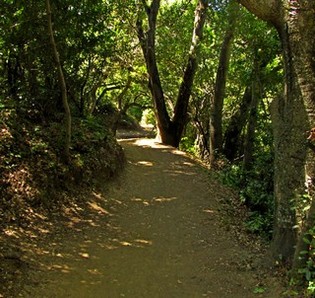 Seven Springs Loop Trail
- 0.0 mi: Start up the road past the Visitor Center.
- 0.1 mi: Turn left through the gate onto the dirt fire road along Stevens Creek (Stevens Creek / Tony Look Trail).
- 0.5 mi: Turn left and start climbing up the Coyote Ridge Trail (fire road). The next mile is a fairly steep climb.
- 1.3 mi: Stay right to continue on the Coyote Ridge Trail. In a quarter-mile you will reach the top of the climb!
- 1.9 mi: You will start passing many different trails heading off to the right and left. Continue following signs for the Coyote Ridge Trail all of the way to the back of the park where you will find the entrance gate to Garrod Farms.
- 2.5 mi: Bear left at the entrance gate to Garrod Farms, heading toward the Toyon Trail.
- 2.7 mi: Turn left onto the Toyon Trail for some great singletrack. You will follow the Toyon Trail for the next 1.5 miles.
- 3.4 mi: Turn right to continue on the Toyon Trail.
- 3.8 mi: Stay right to continue on the Toyon Trail.
- 4.1 mi: Toyon Trail ends. Turn right onto the Hayfield Trail (fire road), heading toward the Seven Springs Loop
- 4.4 mi: Turn right to head toward the Seven Springs Loop Trail. The trail will soon turn to singletrack, and you will continue to follow the Seven Springs Loop for about 1.5 miles.
- 5.1 mi: Cross over Ranch Road and stay on the Seven Springs Loop Trail. The trail will start climbing. Continue following signs for the Seven Springs Loop Trail.
- 6.1 mi: Seven Springs Loop Trail ends on Hayfield Trail. Turn right on Hayfield Trail. You will pass several other trails, but continue following the Hayfield Trail all of the way up to the Coyote Ridge Trail.
- 6.8 mi: Hayfield Trail ends on the Coyote Ridge Trail. Turn right on Coyote Ridge Trail. You will follow the Coyote Ridge Trail all of the way back to your car.
- 8.1 mi: Coyote Ridge Trail ends at Stevens Creek. Turn right and follow the fire road back out to the parking area.
- 8.6 mi: Back at your car!
Favorite Run #2: Tony Look / Ridge Loop (6.7 mi, ~1000 feet elevation gain) 🐾
|
This run features some of the lesser-traveled singletrack in Fremont Older OSP. The Tony Look Trail and Lookout Trail are beautiful "switchback-y" singletrack trails cut into the hills above the reservoir. Because they are off-limits to bikers and horses these trails see less traffic than other trails in the park. Another highlight of this route is a side trip to the highest point in the park, Maisie's Peak, which affords beautiful 360-degree views of the Bay Area.
This run starts from the Stevens Creek County Park north parking area (note there is a fee to park here). Begin the run by continuing along the paved entrance road across Stevens Creek toward the Visitor Center. GPX Track Printable Trail Map Driving Directions |
|
Route Details:
- 0.0 mi: Start up the road past the Visitor Center.
- 0.1 mi: Turn left through the gate onto the dirt fire road along Stevens Creek (Stevens Creek / Tony Look Trail).
- 0.5 mi: Veer right to follow the Stevens Creek / Tony Look Trail. You will climb briefly, then pass by the Stevens Creek Reservoir dam. The trail then hugs the side of the reservoir for the next half-mile.
- 1.0 mi: Turn left to continue on the Stevens Creek / Tony Look Trail. You'll follow this awesome singletrack for the next two miles. You'll pass a couple of trails heading toward Stevens Canyon Road, but just keep following signs for Stevens Creek / Tony Look Trail.
- 2.9 mi: Tony Look Trail ends at Stevens Canyon, but just before the paved road veer left onto the Lookout Trail. Get ready for 3/4-mile switchback climb up to the ridge!
- 3.7 mi: At the top of Lookout Trail! Continue straight ahead under the power lines, then veer right onto the first singletrack you come to. This trail is called Wedding Trail, although there are no signs. However, it is the first and only singletrack trail on your right side. Follow the Wedding Trail until it ends on the Coyote Ridge Trail (fire road).
- 4.1 mi: Make a sharp left turn onto Coyote Ridge Trail (fire road). You'll follow Coyote Ridge Trail for the next couple of miles.
- 4.5 mi: Take a brief detour to Maisie's Peak on the right (the highest point in Fremont Older OSP). The trail is steep but short, and the views from the peak are pretty cool! Then backtrack and continue on Coyote Ridge Trail. After a half-mile the trail will start descending fairly steeply down to Stevens Creek.
- 6.2 mi: Coyote Ridge Trail ends. Turn right onto the fire road (Stevens Creek / Tony Look Trail).
- 6.7 mi: Back at the car!
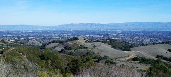
The view from Maisie's Peak