Huddart and Wunderlich Park Super-Loops
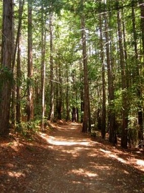
Richards Road Trail in Huddart Park
A great option for a long loop run is to connect Huddart County Park and Wunderlich County Park in Woodside. Even though the parks do not border each other, you can connect the lower entrances of the two parks via paved roads, and you can connect the tops of the two parks via the Skyline Trail. The section of Skyline Trail between Huddart and Wunderlich is six miles of gorgeous rolling singletrack heaven through stunning redwood forest. In fact, just getting the opportunity to run the Skyline Trail is reason enough for doing this loop!
The Dirt:
Extras:
The Dirt:
- Click here for a printable two-page map of the Super-Loop run!
- Click here for driving directions to the Wunderlich Park parking lot.
Extras:
- There are a few different trail race groups that host 50k races here several times per year. Our favorite is the Inside Trail Racing "Woodside Ramble".
- There is water available at the Kings Mountain Fire Station, which adds a 2-mile out-and-back to this loop (refer to the run directions).
Huddart-Wunderlich Super-Loop (18.0 mi, ~2700 feet elevation gain)
|
This Super-Loop takes you through the quiet streets of Woodside, on a nice moderate climb through Huddart Park up to Skyline, along the beautiful rolling Skyine Trail, and then on a sweeping 5.5-mile descent through Wunderlich Park. The highlight of this run is the 5-mile section of the Skyline Trail that connects Huddart Park to Wunderlich Park. Note that some of the turns can be confusing, so we recommend that you print out the trail map or download the GPX track to your GPS device!
This run starts at the parking lot of Wunderlich County Park. Begin the run by heading back down the driveway towards Woodside Road (Hwy 84). Turn left and run along the side of Woodside Road towards Woodside. GPX Track Printable Trail Map Driving Directions |
|
Route Details:
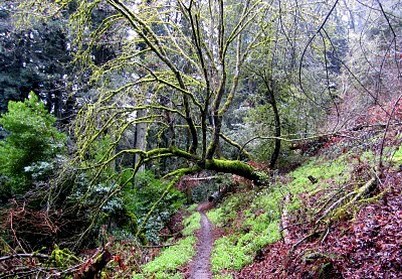 Skyline Trail between Huddart and Wunderlich
- 0.0 mi: Head back down the driveway, turn left on Woodside Road (Hwy 84), and run alongside the road. Be careful! The road is narrow and there are some blind curves. After a few minutes you'll see a little bridge and a trail along the left side of the road. Cross the road and get onto this trail, which follows Woodside Road for the next half mile or so.
- 0.8 mi: Continue straight onto Tripp Road.
- 1.6 mi: Tripp Road ends on Kings Mountain Road. Cross Kings Mtn Road and turn left onto the dirt path.
- 1.7 mi: Turn right onto Greer Road. In 0.6-miles you will see the Huddart Park entrance on your left.
- 2.3 mi: Turn left through the gate into Huddart Park. Get onto the small trail towards the West Meadow picnic area (you can also just follow the paved road).
- 2.5 mi: Continue through the West Meadow picnic area on the paved road, then go around the wooden fence and get onto the Bay Tree Trail (singletrack) toward the Werder picnic area.
- 3.2 mi: At the paved parking lot for the Werder picnic area. Get water if needed, then get onto the Crystal Springs Trail toward the Dean Trail (Note: there are two ways to go on the Crystal Springs Trail - do NOT go downhill toward Richards Road! If you start descending you've gone the wrong way!).
- 3.4 mi: Turn left onto the Dean Trail to start a moderate climb. You will run alongside roads or parking areas a few times in the next mile - just keep following the signs for the Dean Trail.
- 4.7 mi: The Dean trail widens and intersects with Chinquapin Trail. Cross over the dirt road and make a sharp left onto Chinquapin Trail towards Skyline Road.
- 6.5 mi: The Chinquapin Trail ends on the Skyline Trail (fire road). Cross over the dirt road to get onto the Skyline Trail singletrack towards Wunderlich Park. (Note: If you want to get water, turn right onto the fire road and follow it to Skyline Road, then turn right on Skyline and run about 0.8 miles to Kings Mountain Fire Station and go around back to the hose. Then retrace your steps back to the Skyline Trail. This diversion adds about 2 miles to the run.)
- 6.7 mi: Cross Kings Mountain Road and turn left to continue on the Skyline Trail. Prepare yourself for 5.8 miles of beautiful, rolling singletrack as you head towards Wunderlich Park!
- 12.2 mi: After a few uphill switchbacks the trail crosses Bear Gulch Road. When you pop out onto the road, look to your right and you'll see the continuation of the trail. Only a few more switchbacks to the top!
- 12.5 mi: At the top of the Alambique Trail in Wunderlich Park! Turn left and start heading down the Alambique Trail (fire road).
- 14.9 mi: At "The Crossroads." Continue downhill on the Alambique Trail.
- 15.5 mi: Turn left onto the singletrack Bear Gulch Trail, which you will take all of the way back to the car. There is a brief climb here.
- 15.8 mi: At "The Meadows." Continue across the clearing onto the Bear Gulch Trail.
- 16.6 mi: At "Redwood Flat." Continue on the Bear Gulch Trail.
- 17.3 mi: Intersection with the Madrone Trail. Continue on the Bear Gulch Trail.
- 17.8 mi: Intersection with Loop Trail. Continue on the Bear Gulch Trail.
- 18.0 mi: Continue around the old stables and you will see the parking lot and your car!!