Pleasanton Ridge Regional Park (and Augustin Bernal Community Park)
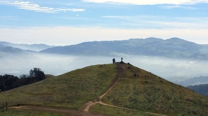
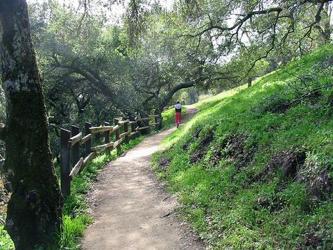
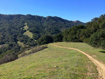
Pleasanton Ridge Regional Park is centrally located in the East Bay hills between Sunol and Pleasanton. It is a surprisingly beautiful park, only minutes from I-680. The trails along the ridge offer expansive views of the Pleasanton area and are popular with hikers, bikers, and equestrians. But, drop down into Kilkare Canyon in the north end of the park and you'll feel like you are in the middle of the wilderness. The land along the southern ridge was once owned by the Thermal Fruit Company, which cultivated non-irrigated orchards of apricot, cherry, prunes, and almonds. The company operated from 1904 until the early 1930's, producing dried fruits. In that area of the park you can still see the faint marks on some hillsides from the now-gone rows of trees, or of vineyards that also existed at various times.
Pleasanton Ridge Regional Park offers over 25 miles of well-marked trails. Most of the "official" trails in the park are dirt roads, with the exceptions of the Woodland Trail, the Bay Leaf Trail, and a few sections of the North Ridge and Ridgeline trails. Elevations in the park range from about 400' at the entrance to just over 1600' at the high point of the ridge. The climbs can be difficult in places, but generally the steep climbs are not very long. The weather can be quite hot in the summer, so wear your hat and sunscreen! Luckily, drinking water is available multiple places in the park. This makes Pleasanton Ridge a great place to do a self-supported longer run or hike of 20+ miles. For an example route, see Favorite Run #3 below...
Pleasanton Ridge Regional Park offers over 25 miles of well-marked trails. Most of the "official" trails in the park are dirt roads, with the exceptions of the Woodland Trail, the Bay Leaf Trail, and a few sections of the North Ridge and Ridgeline trails. Elevations in the park range from about 400' at the entrance to just over 1600' at the high point of the ridge. The climbs can be difficult in places, but generally the steep climbs are not very long. The weather can be quite hot in the summer, so wear your hat and sunscreen! Luckily, drinking water is available multiple places in the park. This makes Pleasanton Ridge a great place to do a self-supported longer run or hike of 20+ miles. For an example route, see Favorite Run #3 below...
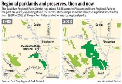
As of 2016 there is only one official staging area for the park, located off of Foothill Road just north of Sunol. However, Pleasanton Ridge Regional Park is continuously expanding with the acquisition of new lands. In fact, from 2007-2013, Pleasanton Ridge grew from 5,000 acres to 8,800 acres making it one of the district's fastest growing and largest parks. The only lager park is Ohlone Regional Wilderness at 9,700 acres. The master park plan includes a total of 63 miles of trails, backpack camps, and three additional staging areas. In addition, the district is planning connecting trails to several other parks in the area.
Pleasanton Ridge Regional Park adjoins Augustin Bernal Community Park, which includes about 5 miles of trails extending from the ridge down to the residential areas along Foothill Road. This provides an additional trailhead to access Pleasanton Ridge Regional Park (for example, see Favorite Run #2 below). The main trailhead and parking for Augustin Bernal Park is at the end of Golden Eagle Way, past the control gate of the Golden Eagle Farms residential development in Pleasanton. Visitors must present a permit card at the control gate, available during regular business hours from the Pleasanton Community Services office at 200 Old Bernal Ave.
Pleasanton Ridge Regional Park adjoins Augustin Bernal Community Park, which includes about 5 miles of trails extending from the ridge down to the residential areas along Foothill Road. This provides an additional trailhead to access Pleasanton Ridge Regional Park (for example, see Favorite Run #2 below). The main trailhead and parking for Augustin Bernal Park is at the end of Golden Eagle Way, past the control gate of the Golden Eagle Farms residential development in Pleasanton. Visitors must present a permit card at the control gate, available during regular business hours from the Pleasanton Community Services office at 200 Old Bernal Ave.
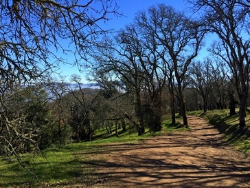
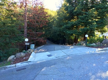 Access to Augustin Bernal at the end of Longview Drive
However, there is another trailhead for Augustin Bernal Park located the end of Longview Drive in Pleasanton, and you may park along the south side of Longview Drive near Foothill Road under the eucalyptus trees. To access the park, continue up the very steep Longview Drive until it ends at a cul-de-sac, then turn left onto what looks like a paved driveway labeled with the address "9104." You should see a small brown sign on a wooden fence indicating access to Augustin Bernal Park. Continue on this road a tenth of a mile to the park gate.
In addition to the "official" trails, Pleasanton Ridge and Augustin Bernal are well-known among mountain bikers for their extensive network of unofficial singletrack trails. Some of these trails include very technical downhills with massive drops and jumps. These trails do not have signs indicating them as illegal; however, you can still be ticketed for being on them. Our Favorite Runs below follow official trails only! But, with some searching you can easily find the unofficial trails if you are so inclined.
In addition to the "official" trails, Pleasanton Ridge and Augustin Bernal are well-known among mountain bikers for their extensive network of unofficial singletrack trails. Some of these trails include very technical downhills with massive drops and jumps. These trails do not have signs indicating them as illegal; however, you can still be ticketed for being on them. Our Favorite Runs below follow official trails only! But, with some searching you can easily find the unofficial trails if you are so inclined.
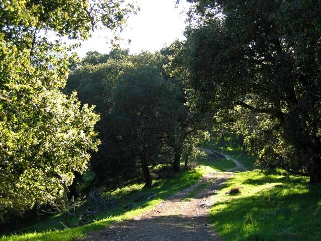
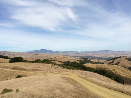
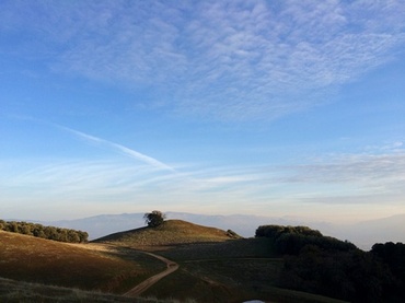 Sunset on Pleasanton Ridge
The Dirt:
Extras:
- Printable trail maps are available for each Favorite Run below!
- Click here for the official Pleasanton Ridge website with trail map.
- Click here for more information about Augustin Bernal Community Park.
- Click here for driving directions to the Pleasanton Ridge main staging area.
- Click here for driving directions to Longview Drive, from which you can access Augustin Bernal Park.
- Dogs are allowed in both parks, and may be off-leash away from trailheads, parking lots, and areas marked as on-leash only. Refer to the East Bay Regional Park page on Dogs for more information.
Extras:
- There is drinking water available at multiple locations within the park. Refer to the trail map for locations.
- Pleasanton Ridge Regional Park adjoins Augustin Bernal Community Park, which includes about 5 miles of trails.
Favorite Run #1: Sinbad Creek Figure-8 (12.0 mi, ~2000 feet elevation gain) 🐾
|
This route takes you on a tour of the southern and middle section of Pleasanton Ridge Regional Park. From the main trailhead, this route first climbs to the Ridgeline Trail for sweeping views of Mount Diablo and the Pleasanton and Livermore valleys. You then descend to secluded Kilkare Canyon and visit pretty Sinbad Creek. After climbing out of the canyon, the route back to the trailhead includes a the long rolling Thermalito trail with great views of the Kilkare Canyon. Please note: In the summer, Sinbad Creek is often completely dry; however, in the winter it may be full of water so expect a creek crossing with up to 1-foot of water.
The run starts from the main parking lot and staging area along Foothill Road. Begin the run by heading up the Oak Tree Trail. GPX Track Printable Trail Map Driving Directions |
|
|
Route Details:
Note: Numbers in parentheses indicate the trail marker number at each intersection
|
Climbing up Woodland Trail
Ridgeline Trail
Descending the Bay Leaf Trail
|
Favorite Run #2: The North Side Loop (12.9 mi, ~2500 feet elevation gain) 🐾
|
This loop explores the more remote north end of Pleasanton Ridge Regional Park. Instead of starting from the main trailhead, this route enters the park through Augustin Bernal Park which allows direct access to the northern end of Pleasanton Ridge. The hardest part of this route is the initial 2.5 miles which climb over 1000' to the ridge. After this, the route then drops into Kilkare Canyon and heads north along Sinbad Creek. You then take a brief detour on the Bay Leaf Trail, one of the few "official" singletracks in the park, which offers amazing views on a clear day. You then continue north through the canyon and climb back to the ridge for more amazing views. After a rolling section along the ridge you finally head back down through Augustin Bernal Park to your car.
This run starts from the Longview Drive entrance to Augustin Bernal Park. From Foothill Road, turn onto Longview Drive and park along the south side of the road under the eucalyptus trees. To reach the trailhead, head up Longview Drive to the cul-de-sac, then turn left onto a paved driveway labeled with the address "9104." Continue up this road a tenth of a mile to the park gate. GPX Track Printable Trail Map Driving Directions |
|
|
Route Details:
Note: Numbers in parentheses indicate the trail marker number at each intersection
|
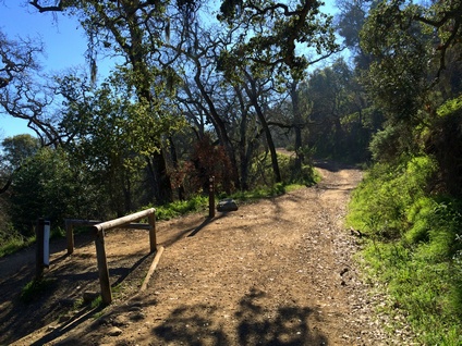
Augustin Bernal Park - Valley View Trail
The Bay Leaf Trail singletrack
The view from Turtle Pond Trail
The view from North Ridge Trail
|
Favorite Run #3: Pleasanton Ridge Grand Tour (20.2 mi, ~3100 feet elevation gain) 🐾
|
Are you training and want a tough, long run with multiple water stops and spectacular Bay Area views? This gigantic route explores the entire park, including the remote north end which offers remote trails with stellar views of the Livermore Valley.
The route begins with a tough 1-mile climb to the ridge. After this, the route continues to climb along the ridgeline, then drops into Kilkare Canyon. After a brief detour on the Bay Leaf Trail (one of the few "official" singletracks in the park), you continue gradually climbing north through the canyon. At the far north end the route includes a two-mile out-and-back to a viewpoint that offers stellar views of the Livermore Valley. You then climb back up to the ridgeline for more great views. The return route follows a different route along the backside of the ridge for more great views before finally descending back to the trailhead. The run starts from the main parking lot along Foothill Road. Begin the run by heading up the Oak Tree Trail. GPX Track Printable Trail Map Driving Directions |
|
Route Details:
|
Note: Numbers in parentheses indicate the trail marker number at each intersection
|

The Ridgeline Trail
View from the end of Cowing Trail
Great view from North Ridge Trail
|
- 13.6 mi: (#34) Water available. The singletrack ends back at the main North Ridge Trail. Veer right to continue on North Ridge Trail.
- 13.8 mi: (#33) Just before the park gate, make a hard right turn onto Shady Creek Trail and descend for 0.4-miles. Keep an eye out on your left for the narrow Ridgeline Trail.
- 14.2 mi: Turn left onto the singletrack Ridgeline Trail, and climb 1/2-mile back up to the ridge.
- 14.7 mi: Veer right onto the dirt road section of the Ridgeline Trail, and continue on the Ridgeline Trail for two miles to Thermalito Trail.
- 15.5 mi: (#22) Water available at the intersection with Sinbad Creek Trail. Stay on the Ridgeline Trail. Just after Sinbad Creek Trail, the Ridgeline Trail splits. Take either route as they shortly join up again.
- 16.7 mi: Water available. Turn right onto Thermalito Trail, and you will see a water fountain on your right. Climb briefly, then descend and go through the gate (#20). You will stay on Thermalito Trail for the next 2.3 miles as it winds along the backside of the ridge. You will see several parallel side trails that you can try out if you wish!
- 17.8 mi: (#17) Veer right to stay on Thermalito Trail.
- 18.5 mi: (#13) Veer right at Olive Grove Trail to stay on Thermalito Trail.
- 19.0 mi: (#8) After a short descent, turn left onto Oak Tree Trail toward the main parking lot.
- 19.3 mi: (#5) Go through the gate, then turn right onto the singletrack Woodland Trail, which descends down several switchbacks.
- 20.0 mi: (#2) When Woodland Trail ends, turn right onto Oak Tree Trail.
- 20.2 mi: (#1) Back at your car!