Point Reyes National Seashore
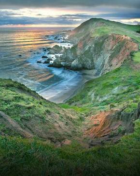
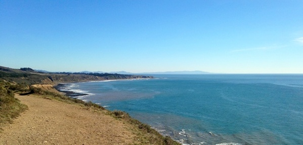
Point Reyes National Seashore is a spectacular 71,000-acre park located along the Pacific coast about an hour north of San Francisco. The park is geologically separated from the rest of Marin County by a rift zone of the San Andreas Fault, about half of which is sunk below sea level and forms beautiful Tomales Bay. Point Reyes National Seashore is an interesting and varied landscape. The eastern side of the park is characterized by densely wooded hillsides, whereas the western side is completely different with grassy slopes leading down to sheer cliffs that drop directly to the Pacific Ocean. The park is gorgeous year-round; however, springtime is a particularly great time to visit when the hillsides are covered in displays of brilliant wildflowers.
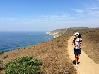
Point Reyes National Seashore offers over 150 miles of well-maintained trails, perfect for running or hiking. Elevations in the park range from sea level to 1,407' at the summit of Mount Wittenberg, the highest point in the park. Even though the views from the summit itself are obscured by dense evergreen trees, the trails to the summit offer spectacular views of the rugged Northern California coastline.
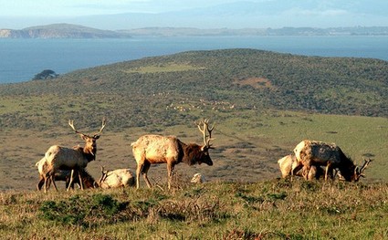
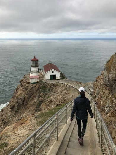
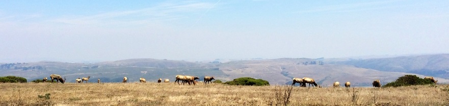
The park abounds with things to see and do. Alamere Falls is a stunning coastal waterfall dropping 40' down a sheer cliff directly to the beach. Arch Rock is a natural arch through which the Coast Creek flows into the ocean. Tomales Bay, formed by the rift zone of the San Andreas Fault, is a 15-mile long protected tidal bay, perfect for kayaking. The Tule Elk Reserve at Tomales Point is a protected preserve for Tule Elk, which had almost completely disappeared in the mid-1800's but are now thriving in the Reserve. The historic Point Reyes Lighthouse, built in 1870, guided mariners for over 100 years.
Point Reyes National Seashore also offers four hike-in campgrounds: Coast Camp, Glen Camp, Sky Camp, and Wildcat Camp. Camping is by reservation only, and reservations must be made well in advance, particularly if you want to reserve on a weekend. All of the campgrounds offer water; however, the water may or may not be potable so it is highly recommended to filter or purify any water before drinking.
There are multiple trailheads at Point Reyes. The Favorite Runs on this page start from either the Bear Valley Visitor Center or the Palomarin Trailhead at the end of Mesa Road near Bolinas.
Point Reyes National Seashore offers over 150 miles of well-maintained trails, perfect for running or hiking. Elevations in the park range from sea level to 1,407' at the summit of Mount Wittenberg, the highest point in the park. Even though the views from the summit itself are obscured by dense evergreen trees, the trails to the summit offer spectacular views of the rugged Northern California coastline.
The park abounds with things to see and do. Alamere Falls is a stunning coastal waterfall dropping 40' down a sheer cliff directly to the beach. Arch Rock is a natural arch through which the Coast Creek flows into the ocean. Tomales Bay, formed by the rift zone of the San Andreas Fault, is a 15-mile long protected tidal bay, perfect for kayaking. The Tule Elk Reserve at Tomales Point is a protected preserve for Tule Elk, which had almost completely disappeared in the mid-1800's but are now thriving in the Reserve. The historic Point Reyes Lighthouse, built in 1870, guided mariners for over 100 years.
Point Reyes National Seashore also offers four hike-in campgrounds: Coast Camp, Glen Camp, Sky Camp, and Wildcat Camp. Camping is by reservation only, and reservations must be made well in advance, particularly if you want to reserve on a weekend. All of the campgrounds offer water; however, the water may or may not be potable so it is highly recommended to filter or purify any water before drinking.
There are multiple trailheads at Point Reyes. The Favorite Runs on this page start from either the Bear Valley Visitor Center or the Palomarin Trailhead at the end of Mesa Road near Bolinas.
 Tule Elk near Tomales Point
The Dirt:
Extras:
- Download a printable trail map of the Favorite Runs below!
- Click here to visit the the official park website
- Click here for links to trail maps of Point Reyes National Seashore
- Purchase the National Geographic Point Reyes/Mount Tam map through the Trailstompers Store!
- Click here for driving directions to the Bear Valley Visitor Center Trailhead
- Click here for driving directions to the Palomarin Trailhead
- Point Reyes is a hot spot for poison oak. Click here to learn about preventing and treating poison oak rashes.
- Dogs are NOT allowed in Point Reyes National Seashore.
Extras:
- There are four hike-in campgrounds in Point Reyes National Seashore. Reservations must be made well in advance. Visit the official park website for reservation information.
- Tomales Bay is one of the most popular kayaking destinations in the area. Blue Waters Kayaking offers guided tours, including an evening bioluminescence tour of the bay!
- After your run or hike, check out Heart's Desire Beach at Tomales Bay State Park. This sandy beach is one of the few swimming beaches in Marin County.
The Point Reyes Lighthouse
|
One of the most popular attractions at Point Reyes National Seashore is the historic lighthouse, located at the western tip of Point Reyes 300 feet above the Pacific Ocean. The lighthouse operated from 1870 to 1975 and contains one of the best preserved examples of a first-order Fresnel lens, which focused the light so it could be seen up to 24 miles away. Point Reyes is the windiest place on the Pacific Coast and the second foggiest place on the North American continent. Weeks of fog, especially during the summer months, frequently reduce visibility to hundreds of feet. Over 50 known shipwrecks have occurred around Point Reyes. The lighthouse was built to help ships navigate around the treacherous point, which juts 10 miles out into the Pacific Ocean.
As of 2017, the lighthouse is open Friday through Monday and can be accessed by driving to the end of Sir Francis Drake Boulevard, about 45 minutes from the Bear Valley Visitor Center. On weekends, holidays, and during whale watching season, the last part of the road is closed to traffic and you must take a shuttle from the Kenneth C. Patrick Visitor Center. Refer to the park website for more information. |
Favorite Run #1: Arch Rock out-and-back (8.9 mi, ~900' elevation gain)
|
This run is an easy out-and-back from Bear Valley Visitor Center to the coast and the unique Arch Rock. The route follows the wide Bear Valley Trail, which climbs for the first two miles then descends gradually to the coast. Once you reach the Arch Rock overlook, there is a small unmaintained trail that leads steeply down to Coast Creek and a view of Arch Rock. NOTE: In 2015 the arch tragically collapsed, killing one hiker.
This run starts from the Bear Valley Visitor Center. To begin the run, head through the parking lot and start up the well-marked Bear Valley Trail. GPX Track Printable Trail Map Driving Directions |
|
Route Details:
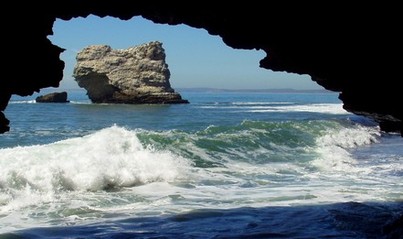 View of the Pacific Ocean through Arch Rock (collapsed in 2015)
- 0.0 mi: Start along the Bear Valley Trail. You will stay on this trail for the next 4.5 miles, all of the way to the coast.
- 4.2 mi: At the Coast Trail intersection. Keep going straight ahead on the narrow trail toward Arch Rock.
- 4.5 mi: At the former Arch Rock overlook. In 2015, the arch tragically collapsed, killing one hiker. The view is still spectacular; however, the arch is now gone.
- 8.9 mi: Back at your car!
Favorite Run #2: Mount Wittenberg Loop (11.4 mi, ~2000' elevation gain)
|
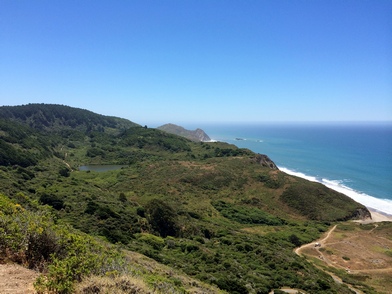
This run is a spectacular loop that takes you through the dense inland forests along the Bear Valley Trail to the dramatic coastline, and then returns along the Sky Trail with a climb over Mount Wittenberg. At 1,407', Mount Wittenberg is the highest point in the park. The view from the actual summit is obscured by dense evergreen trees; however, the climb to the summit offers spectacular views of the coastal cliffs and the Pacific Ocean.
This run starts from the Bear Valley Visitor Center. To begin the run, head through the parking lot and start up the well-marked Bear Valley Trail. GPX Track Printable Trail Map Driving Directions |
|
Route Details:
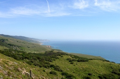 Amazing views of the Point Reyes coast
- 0.0 mi: Start along the wide Bear Valley Trail. You will stay on this trail for the next 4.2 miles all of the way to the coast.
- 4.2 mi: Turn right on the Coast Trail, and keep an eye out for the Sky Trail in a half mile on your right. (Note: If you want, take a side trip out to Arch Rock and back. It's only about 0.4 miles round trip.)
- 4.7 mi: Turn right onto Sky Trail and start climbing. The next four miles are climbing, with the first half-mile being the steepest section. There are spectacular views the next four miles.
- 6.2 mi: Pass Baldy Trail on your right. Stay on the Sky Trail.
- 7.5 mi: Pass Old Pine Trail on your right. Stay on the Sky Trail.
- 7.8 mi: Pass the Woodward Valley Trail on your left. Stay on the Sky Trail.
- 8.5 mi: Just after the Meadow Trail junction, turn right onto the Mt. Wittenberg Trail.
- 8.9 mi: At the junction with Z Ranch Trail, proceed straight ahead onto the marked trail to Mt. Wittenberg Summit.
- 9.2 mi: At the summit! There is a partially obstructed view of the coast from the summit. After you're done here, head back down the summit trail to the Z Ranch Trail junction.
- 9.5 mi: Back at the Z Ranch Trail junction. Turn left to and start descending down the Mt. Wittenberg Trail. The trail is technical in places so watch your footing.
- 11.1 mi: Mt. Wittenberg Trail ends at the Bear Valley Trail. Turn left to head back to the parking lot.
- 11.4 mi: Back at your car!
Favorite Run #3: Alamere Falls out-and-back (8.2 mi, ~1200' elevation gain)
|
This route takes you along the dramatic coastline to Alamere Falls, a 40' waterfall that tumbles down the cliff to the beach below. The waterfall runs all year, but is the most dramatic in the early spring. Along the way, you will pass the beautiful Bass and Pelican Lakes. Bass Lake is a popular spot for floating or jumping from the rope swing hidden in the trees on the north side of the lake. This route initially follows the coast, then turns inland with a few moderate but short climbs before intersecting with the falls trail. Note that the trail to the falls is officially closed; however, as of 2013 is still heavily traveled. It is overgrown with poison oak, so be careful and wash thoroughly after the trip!
This run starts at the Palomarin trailhead at the end of Mesa Road near Bolinas. Note that the last mile of Mesa Road is dirt. The parking lot typically fills up by 10 am in the summer, so get there early! To begin the run, head up the stairs to the left of the bathroom and turn left on the Coast Trail. GPX Track Printable Trail Map Driving Directions |
|
Route Details:
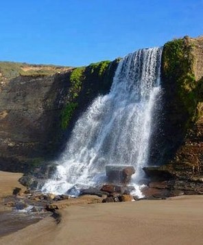 Alamere Falls tumbles 40 feet to the beach
- 0.0 mi: Start out along the Coast Trail. You will follow the Coast Trail all of the way to the Alamere Falls Trail.
- 2.8 mi: Pass Bass Lake on your left. (Note: Just past the lake on the left there is a little spur trail that leads to the rope swing and lake access.)
- 3.5 mi: Pass Pelican Lake on your left.
- 3.7 mi: Just after the Coast Trail curves to the right, you will see a narrow trail on your left heading to the top of Alamere Falls. As of 2014 there is a sign, although the trail is officially closed. Turn left on this trail. The trail winds down to the top of the falls, through thick brush and a LOT of poison oak.
- 4.0 mi: Carefully make your way down the steep eroded section past the upper cascades to the top of the falls.
- 4.1 mi: At the top of Alamere Falls. If you want to head down to the beach, cross over the stream about 50' before it goes over the cliff, and find the unofficial trail on the other side that winds steeply down the cliff to the beach. This trail is extremely steep and loose and not for the faint of heart! When you're done, scramble back up the cliff and retrace your steps back to the car.
- 8.2 mi: Back at your car!
Favorite Run #4: Ridge & Coast Giant Loop (20.5 mi, ~3600' elevation gain)
|
This loop is a challenging tour of some of the best trails in the southern part of Point Reyes National Seashore. After a brief run back along Mesa Road, you turn northward along the Ridge Trail, climbing about 1000' in the first two miles. Even though Point Reyes is an extremely popular area, this southern section of the Ridge Trail is rarely traveled and is narrow and overgrown in spots. After the initial climb, the trail flattens out and rolls along the ridge through dense forests that are often shrouded in fog. The next few miles are downhill to the coast. The remainder of the run is entirely on the Coast Trail which climbs up and over several high cliffs as it makes its way back south to Palomarin Trailhead. Note that there is water available at Wildcat Camp (mile 15). The potability of this water is questionable, so we filter the water just in case.
This run starts at the Palomarin trailhead at the end of Mesa Road near Bolinas. Note that the last mile of Mesa Road is dirt. The parking lot typically fills up by 10 am in the summer, so get there early! To begin the run, head south along Mesa Road (the way you drove in). GPX Track Printable Trail Map Driving Directions |
|
|
Route Details:
|
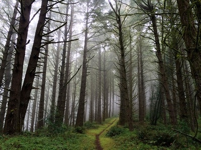
The Ridge Trail eerily shrouded in fog
Descending to Wildcat Camp
The Coast Trail near Palomarin Trailhead
|
Favorite Run #5: Tomales Point Out-and-Back (9.4 mi, ~1200' elevation gain)
|
This amazing run takes you through the Tule Elk reserve to the northernmost tip of Tomales Point. Along the way you get amazing views of the rugged coastline, the Pacific Ocean, and herds of Tule Elk. These native elk had virtually disappeared by 1860 due to hunting. In the spring of 1978, two bulls and eight cows were brought in from the San Luis Island Wildlife Refuge near Los Banos. In 2009, over 440 elk were counted at Tomales Point, making the the Point Reyes herds one of the largest populations in California.
The best time to do this run is in the fall during "rutting" season, when the male elk compete for harems of female elk! From August through October, docents are present along the trail with high-powered spotting scopes, allowing you to watch the herds from a safe distance. This run begins from the Pierce Point Ranch, at the northern end of Pierce Point Ranch Road. From the parking area, take the well-marked trail toward Tomales Point. GPX Track Printable Trail Map Driving Directions |
|
|
Route Details:
|
Tomales Point Trail
|
Tule Elk viewed from Tomales Point Trail