Purisima Creek Redwoods Open Space Preserve
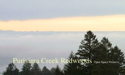
Imagine a park that offers stunning gulches filled with majestic redwood trees, grand sweeping coastal views, and miles of beautiful, well-maintained trails. Now imagine that you can have this park almost completely to yourself, even on the most beautiful weekend day of the year. Now imagine this park is less than an hour drive from Silicon Valley and the urban areas on the San Francisco Peninsula.
Why only imagine? Just check out Purisima Creek Redwoods Open Space Preserve, in the hills above Woodside. This 4,711-acre preserve features 24 miles of well-developed trails surrounding beautiful Purisima Creek Canyon, with its towering redwoods, rushing creek, and understory of ferns, berries, and wildflowers. In addition, the park offers grand views of Half Moon Bay and the Pacific Ocean. Purisima Creek Open Space Preserve is truly a beautiful place, and is easily accessible from Skyline Blvd, just north of Kings Mountain Road.
As an added bonus, directly across Skyline Blvd from Purisima Creek Redwoods Open Space Preserve is Huddart Park, and the two parks can be combined into several challenging loop runs.
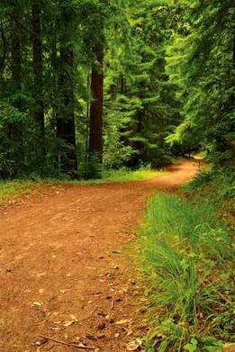 Purisima Creek Trail
The trails in Purisima Creek OSP are a mix of singletrack and dirt roads. The elevations in the park range from about 500 feet at the bottom to just over 2000 feet at Skyline Blvd. Even though there is significant elevation change, most of the trails are moderate with a few steep sections. The weather is mild year-round, and can be foggy and wet in the fall and winter. But, the trails are well-maintained and drain well, even when the weather is wet. Because of the mild weather and shaded trails, Purisima Creek Open Space Preserve is also an excellent destination in the summer when the weather is hot.
The Dirt:
The Dirt:
- Click here for a printable trail map of the Favorite Runs below!
- Click here for the official web site.
- Click here for driving directions to the North Ridge trailhead parking via Google maps.
- There are NO DOGS allowed in the preserve.
- There is no drinking water available in the preserve.
- A long loop run (15+ miles) can be done by combining Huddart Park and Purisima Creek Redwoods OSP. Refer to the Huddart/Purisima Super-Loop run for more details.
Favorite Run #1: Soda Gulch Loop (8.1 mi, ~1400 feet elevation gain)
|
This run is a great introduction to the park, and offers beautiful ocean views on a clear day. To make this run a loop, the first 2 miles follow Skyline Blvd. After descending on Purisima Creek Trail, you turn onto the Craig Britton Trail which takes you through the spectacular Soda Gulch with its towering redwood trees. The final part of the run is a tough singletrack climb back to your car with spectacular views of the Pacific Ocean.
The run starts at the North Ridge trailhead off of Skyline Blvd, located about 2.5 miles north of Kings Mountain Road. Begin the run by exiting the parking lot and turning right on Skyline Blvd. Watch out for cars when running on Skyline Blvd. GPX Track Printable Trail Map Driving Directions |
|
Route Details:
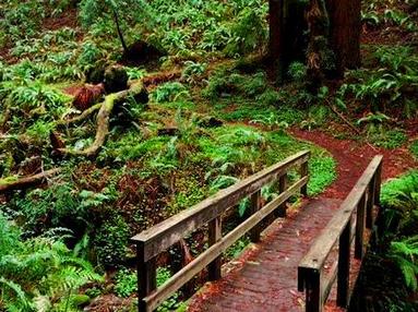 Wooden bridge on Craig Britton Trail
- 0.0 mi: Turn right out of the parking lot and start running along Skyline Blvd.
- 1.4 mi: Pass Kings Mountain Fire Station on your left. (Note that the fire station has a hose out back for water.)
- 2.0 mi: You will see a small dirt parking area along the right side of Skyline Blvd. This is the southern entrance for Purisima Creek Redwoods Open Space Preserve. Turn right and continue past the (stinky!) outhouse onto the Purisima Creek Trail fire road. You will steadily descend for the next 1.8 miles.
- 3.8 mi: Turn right onto Craig Britton Trail. Over the next 2.6 miles, you'll see coastal views and redwood-filled gulches. This trail is awesome!!
- 6.6 mi: Trail ends at Harkins Ridge Trail (fire road). Turn right and start climbing steeply.
- 7.0 mi: Veer left onto the singletrack to stay on Harkins Ridge Trail.
- 7.6 mi: After a brief steep climb, the trail ends at North Ridge Trail. Cross over North Ridge Trail fire road and get onto the North Ridge Trail singletrack. Follow this trail as it switchbacks all of the way back to the parking lot. There are a good views from this trail.
- 8.1 mi: Back at your car!
Favorite Run #2: Whittemore Gulch Loop (9.9 mi, ~1700 feet elevation gain)
|
This is a beautiful and challenging loop run that includes long climbs and descents on perfect trails with some amazing ocean views. To make this run a loop, the first 2 miles are along the shoulder of Skyline Blvd. Next, you get a 4-mile descent down Purisima Creek Trail into the Purisima Creek Canyon and a beautiful redwood forest. Then, gear down for a long 3-mile climb up the Whittemore Gulch Trail, which is one of the most amazing climbs in the Bay Area due to the amazing views and beautiful singletrack. A little more climbing on the North Ridge Trail takes you back to the parking lot and your car.
The run starts at the North Ridge trailhead off of Skyline Blvd, located about 2.5 miles north of Kings Mountain Road. Begin the run by exiting the parking lot and turning right on Skyline Blvd. Watch out for cars when running on Skyline Blvd. GPX Track Printable Trail Map Driving Directions |
|
Route Details:
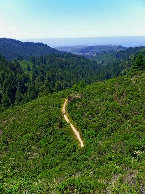 The upper section of Whittemore Gulch Trail
- 0.0 mi: Turn right out of the parking lot and start running along Skyline Blvd.
- 1.4 mi: Pass Kings Mountain Fire Station on your left. (Note that the fire station has a hose out back for water.)
- 2.0 mi: You will see a small dirt parking area along the right side of Skyline Blvd. This is the southern entrance for Purisima Creek Redwoods Open Space Preserve. Turn right and continue past the (stinky!) outhouse onto the Purisima Creek Trail fire road. You will steadily descend for the next 1.8 miles.
- 3.8 mi: Pass Craig Britton Trail on your right. Keep descending on the Purisima Creek Trail.
- 5.1 mi: Pass Grabtown Gulch Trail and Borden Hatch Mill Trail on your left. Stay on Purisima Creek Trail.
- 6.1 mi: At the lower park entrance. Turn right by the information sign and continue up the Whittemore Gulch Trail (don't turn onto the Harkins Ridge Trail accidentally!). There are a few very steep sections near the beginning of the climb, but most of the climb for the next few miles is moderate.
- 8.3 mi: (CONFUSING INTERSECTION!) Shortly after the switchback section, take a hard 180-degree right turn to stay on the Whittemore Gulch Trail. This turn is easy to miss!
- 8.9 mi: Trail ends on the North Ridge Trail (fire road). Turn right onto the North Ridge Trail.
- 9.3 mi: Turn left at the small fence to get on the singletrack section of the North Ridge Trail. Follow this trail all of the way back to the parking lot. There are a some good views from this trail.
- 9.8 mi: Back at your car!