Huddart Park & Purisima Creek Redwoods Super-Loops (15-20+ mi, 2500-3500 ft elevation gain)
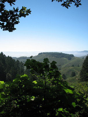 View from North Ridge Trail in Purisima Creek OSP
These super-loop runs link together two of the most beautiful parks on the San Francisco Peninsula, Huddart County Park and Purisima Creek Redwoods Open Space Preserve. Because the two parks lie on either side of Skyline Blvd, it is very easy to connect a loop in each park into a giant figure-8 that encompasses both parks. As an added bonus, there is water available at the Kings Mountain Fire Station, so you can refill your water bottles along the way.
The runs are constructed by combining the 8.7-mile or 10.4-mile loop listed on the Huddart Park page with either of the loop runs listed on the Purisima Creek Redwoods page. After the climb up to Skyline through Huddart Park, simply add one of the Purisima Creek Redwoods loops, then finish off the loop through Huddart. Two of our favorite combinations are described below. The runs can be confusing so we recommend that you print out the trail maps or download the GPX track to your GPS device!
The runs start from the Zwierlein/Werder area parking lot in Huddart Park.
The Dirt:
Extras:
The runs are constructed by combining the 8.7-mile or 10.4-mile loop listed on the Huddart Park page with either of the loop runs listed on the Purisima Creek Redwoods page. After the climb up to Skyline through Huddart Park, simply add one of the Purisima Creek Redwoods loops, then finish off the loop through Huddart. Two of our favorite combinations are described below. The runs can be confusing so we recommend that you print out the trail maps or download the GPX track to your GPS device!
The runs start from the Zwierlein/Werder area parking lot in Huddart Park.
The Dirt:
- Click here to download a 2-page printable map of the Super-Loops below!
- Click here for driving directions to the Zwierlein/Werder parking area in Huddart Park.
- There are NO DOGS allowed in the parks.
Extras:
- There is drinking water available at the Kings Mountain Fire Station on Skyline Blvd. Refer to the run directions and the printable trail map.
Super-Loop #1: Huddart & Soda Gulch Figure-8 (17.0 mi, ~3100 feet elevation gain)
|
This is the "easiest" of the super-loops that combines the "Huddart Loop" with the "Soda Gulch Loop." The run has everything: a gorgeous climb through a redwood forest, a fast fire road descent down Purisima Creek Trail, a trip through the stunning Soda Gulch, a butt-kicking climb up Harkins Ridge, and finally a sweeping singletrack descent down Chinquapin Trail.
This run starts from the south end of the Zwierlein/Werder parking lot. To begin the run, head down the Bay Tree Trail, which starts at the south end of the parking lot. GPX Track Printable Trail Map Driving Directions |
|
Route Details:
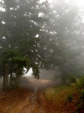 Harkins Ridge Trail in the fog
- 0.0 mi: From the south end of the parking area, head downhill on the Bay Tree Trail.
- 0.7 mi: When the trail ends, take a hard left onto Richards Road Trail.
- 1.1 mi: Continue on Richards Road Trail past the first intersection with Crystal Springs Trail.
- 1.5 mi: Turn left at the second intersection with Crystal Springs Trail.
- 1.6 mi: At the bridge, turn right and start climbing up Crystal Springs Trail. You will climb for the next 3 miles.
- 1.9 mi: Turn left at Chapparal Trail intersection to continue on Crystal Springs Trail.
- 2.1 mi: (CONFUSING INTERSECTION) Stay right at Canyon Trail intersection to continue on Crystal Springs Trail.
- 2.5 mi: (CONFUSING INTERSECTION) Two spurs come off the trail here - be careful to stay on Crystal Springs Trail.
- 2.9 mi: Cross Campground Trail (fire road) and continue on Crystal Springs Trail.
- 3.7 mi: Pass Dean Trail - continue on Crystal Springs Trail. (Short-cut option: Turn left onto the Dean Trail if you want to take the short-cut. After 0.8 miles you'll intersect the Chinquapin Trail. Veer left onto the singletrack Dean Trail and then skip to mile 7.4 below).
- 4.4 mi: Crystal Springs ends on a fire road. Turn right and then left onto Richards Road Trail (fire road). This is a short but steep climb.
- 4.7 mi: Just before Skyline Blvd, turn left onto Skyline Trail (singletrack). (Note: If you want to get water, continue past the Skyline Trail and turn right on the Lonely Trail which will take you to the Kings Mountain Fire Station in 0.3 mi. There is a water hose out back. After filling your bottle, retrace your steps on the Lonely Trail to get back to the Skyline Trail).
- 5.1 mi: Skyline Trail will come within about 10 feet of Skyline Blvd. At this point, look across Skyline and you should see the roadside parking area for Purisima Creek Redwoods Open Space Preserve. Cross over Skyline and start heading down Purisima Creek Trail. You will know you are in the right place if you pass a stinky outhouse! You will steadily descend for the next 1.8 miles.
- 6.9 mi: Turn right onto Craig Britton Trail (formerly Soda Gulch Trail). Over the next 2.6 miles, you'll see coastal views and redwood-filled gulches. This trail is awesome!!
- 9.7 mi: Trail ends at Harkins Ridge Trail (fire road). Turn right and climb steeply.
- 10.1 mi: Veer left onto the singletrack to stay on Harkins Ridge Trail.
- 10.7 mi: After a brief steep climb, the trail ends at North Ridge Trail. Cross over North Ridge Trail fire road and get onto the North Ridge Trail singletrack. Follow this trail all of the way back to the parking lot. There are a couple great viewpoints along this trail.
- 11.2 mi: At the North Ridge parking lot. Continue through the parking lot. Turn right out of the parking lot and start running along Skyline Blvd.
- 12.6 mi: (Water Available) Pass Kings Mountain Fire Station on your left.
- 12.9 mi: You will see a gate and trailhead on your left. This is the top of Richards Road Trail. Head around the gate and descend about 0.1 mile, then turn right onto the singletrack Skyline Trail. This should look familiar now! Continue on Skyline Trail, and this time DO NOT cross Skyline Blvd into Purisima Creek OSP. Instead continue on Skyline Trail until it ends on a fire road.
- 13.5 mi: Turn left on the Skyline Trail Fire Road, following signs for Chinquapin Trail.
- 13.7 mi: Turn left onto Chinquapin Trail, and start an awesome 3-mile descent!
- 15.5 mi: (CONFUSING INTERSECTION) The Chinquapin Trail runs along the left side of Archery Fire Road. Stay left on the singletrack and then around a left-hand switchback. The Chinquapin Trail will then end on the Dean Trail (fire road). Cross the fire road and take a sharp right on the Dean Trail singletrack doing downhill. Make sure you are following signs for the "Ranger Station" and not "Crystal Springs Trail"!
- 15.7 mi: Cross the Archery Fire Road - continue on Dean Trail.
- 16.1 mi: Cross the Archery Fire Road again - continue on Dean Trail.
- 16.3 mi: At the paved road - turn left to stay on the Dean Trail.
- 16.6 mi: Continue past the paved road and stay on the Dean Trail.
- 16.8 mi: Dean Trail ends on the Crystal Springs Trail, turn right toward the parking area.
- 17.0 mi: Back at the Huddart parking lot! Congrats you made it!!
Super-Loop #2: Huddart/Purisima Butt-Kicker (20.4 mi, ~3500 feet elevation gain)
|
Training for a hard 50k and want some tough climbs on amazing trails? Then this super-loop is for you! The route combines the "The Phleger/Huddart loop" with the "Whittemore Gulch Loop" in Purisima Creek Open Space Preserve. From the Huddart parking lot, you'll descend briefly and then face a tough climb up to the Kings Mountain Fire Station through Phleger Estate. Then you'll descend for five miles through Purisima Creek Redwoods, followed by a spectacular climb up the narrow Whittemore Gulch Trail. After a run along Skyline Blvd, you'll finish with a sweeping 3-mile descent on the Chinquapin Trail back to the Huddart parking lot.
This run starts from the south end of the Zwierlein/Werder parking lot. To begin the run, head down the Bay Tree Trail, which starts at the south end of the parking lot GPX Track Printable Trail Map Driving Directions |
|
Route Details:
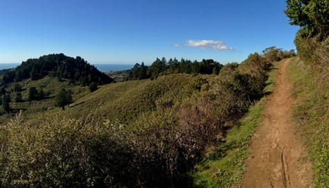 Beautiful section of Whittemore Gulch Trail
- 0.0 mi: From the south end of the parking area, head downhill on the Bay Tree Trail.
- 0.7 mi: When the trail ends, take a hard left onto Richards Road Trail.
- 1.1 mi: Continue on Richards Road Trail past the first intersection with Crystal Springs Trail.
- 1.5 mi: Continue on Richards Road Trail past the second intersection with Crystal Springs Trail.
- 1.6 mi: Veer right onto Miramontes Trail and enter Phleger Estate. You will follow Union Creek on a beautiful singletrack trail for the next mile.
- 3.0 mi: Turn right at the intersection with Mt. Redondo Trail, head downhill briefly, then turn left onto Raymundo Trail. Get ready for some climbing!!
- 4.6 mi: Just after the Raymundo trail flattens out, turn right onto Lonely Trail for more climbing!! (You didn't think you were done, did you??)
- 5.2 mi: Pass the first bench.
- 5.5 mi: Pass the second bench.
- 6.1 mi: The trail flattens out and reaches an intersection. Turn left to continue on the Lonely Trail. (Note: If you want to get water at the Kings Mountain Fire Station, turn right at this intersection. In 0.1 mile you will see the fire station, and there is a water hose out back. After filling your bottle, retrace your steps on the Lonely Trail).
- 6.4 mi: The Lonely Trail ends at Richards Road Trail. Turn left (downhill), then immediately turn right onto the Skyline Trail (singletrack).
- 6.8 mi: Skyline Trail will come within about 10 feet of Skyline Blvd. At this point, look across Skyline and you should see the roadside parking area for Purisima Creek Redwoods Open Space Preserve. Cross over Skyline and start heading down Purisima Creek Trail. You will know you are in the right place if you pass a stinky outhouse! You will steadily descend for 4 miles to the lower park entrance.
- 8.6 mi: Pass Craig Britton Trail on your right. Keep descending on the Purisima Creek Trail.
- 9.9 mi: Pass Grabtown Gulch Trail and Borden Hatch Mill Trail on your left. Stay on Purisima Creek Trail.
- 10.9 mi: At the lower park entrance. Turn right by the information sign and continue up the Whittemore Gulch Trail (don't turn onto the Harkins Ridge Trail accidentally!). There are a few very steep sections near the beginning of the climb, but most of the climb for the next few miles is moderate.
- 13.1 mi: (CONFUSING INTERSECTION) Shortly after the switchback section, take a hard 180-degree right turn to stay on the Whittemore Gulch Trail. This turn is easy to miss!
- 13.7 mi: Trail ends on the North Ridge Trail (fire road). Turn right onto the North Ridge Trail.
- 14.1 mi: Turn left at the small fence to get on the singletrack section of the North Ridge Trail. Follow this trail all of the way back to the parking lot. There are a couple great viewpoints along this trail.
- 14.6 mi: At the North Ridge parking lot. Continue through the parking lot. Turn right out of the parking lot and start running along Skyline Blvd.
- 16.0 mi: (Water Available) Pass Kings Mountain Fire Station on your left.
- 16.3 mi: You will see a gate and trailhead on your left. This is the top of Richards Road Trail. Head around the gate and descend about 0.1 mile, then turn right onto the singletrack Skyline Trail. This should look familiar now! Continue on Skyline Trail, and this time DO NOT cross Skyline Blvd into Purisima Creek OSP. Instead continue on Skyline Trail until it ends on a fire road.
- 16.9 mi: Turn left on the Skyline Trail Fire Road, following signs for Chinquapin Trail.
- 17.1 mi: Turn left onto Chinquapin Trail, and start an awesome 3-mile descent!
- 18.9 mi: (CONFUSING INTERSECTION) The Chinquapin Trail runs along the left side of Archery Fire Road. Stay left on the singletrack and then around a left-hand switchback. The Chinquapin Trail will then end on the Dean Trail (fire road). Cross the fire road and take a sharp right on the Dean Trail singletrack doing downhill. Make sure you are following signs for the "Ranger Station" and not "Crystal Springs Trail"!
- 19.1 mi: Cross the Archery Fire Road - continue on Dean Trail.
- 19.5 mi: Cross the Archery Fire Road again - continue on Dean Trail.
- 19.7 mi: At the paved road - turn left to stay on the Dean Trail.
- 20.0 mi: Continue past the paved road and stay on the Dean Trail.
- 20.2 mi: Dean Trail ends on the Crystal Springs Trail, turn right toward the parking area.
- 20.4 mi: Back at the Huddart parking lot! Congrats you made it!!