Skyline-to-the-Sea (Almost) via Butano Ridge (24.0 mi, ~3000 feet elevation gain)
|
If you are an avid runner or hiker in the San Francisco Bay Area, you are probably familiar with the Skyline-to-the-Sea Trail, the 25-mile trail that connects Skyline Blvd at Saratoga Gap to the Pacific Ocean at Waddell Beach. But, did you know that the Penninsula Open Space Trust (POST) has planned three additional routes leading from Skyline to the ocean? The northernmost two routes are years away from completion; however, as of 2014 the Butano Ridge Route is almost complete, with only the last 3 miles remaining to be opened to the public. The existing 24 miles of the route connect Skyline Blvd just north of Saratoga Gap to Cloverdale Road in Pescadero, passing through Long Ridge Open Space Preserve, Portola Redwoods State Park, Big Basin Redwoods State Park, and Butano State Park. The final 3 miles would eventually pass through Cloverdale Coastal Ranches and end at the Pacific Ocean. However, it is unclear from the Peninsula Open Space Trust website when or if the remaining section of trail will be opened to the public.
|
|
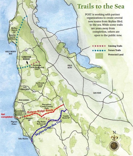 Existing and future "Skyline-to-the-Sea" routes.
 The Butano Ridge Route is shown in red.
www.openspacetrust.org
The majority of the Butano Ridge Route is generally downhill, except for a challenging 2000' foot singletrack climb in the middle of the route. Most of the trail is shaded, except for the first two miles and the last four miles of the route. The route is approximately 40% singletrack and 60% dirt road. The run starts at the Long Ridge trailhead on Skyline Blvd, 1.5 miles north of the Hwy 9 intersection at Saratoga Gap. Starting from Skyline Blvd, the initial section along Long Ridge is rolling and offers spectacular views of Butano Ridge and the Pacific Ocean in the distance. It then drops 2000' through dense redwoods, following Slate Creek to the Portola Redwoods State Park Office. There is drinking water available at the office. (As of October 2014 the Portola Redwoods State Park Office is closed and all water is shut off!! Check the park website for more details!) After a brief run along the park service road, the route then climbs up a narrow singletrack through what seems like an infinite number of switchbacks to the top of Butano Ridge. It then follows the ridge to Big Basin Redwoods State Park, where the route intersects the Butano Fire Road. The final eleven miles are generally downhill along the Butano Fire Road all of the way to Cloverdale Road in Pescadero.
Unlike the well-known Skyline-to-the-Sea Trail, the Butano Ridge Route is not a single continuous trail and you will not see any signs that indicate the route as a "Skyline-to-the-Sea" route. In general this route is not well-marked and some sections are confusing, particularly some parts of the Basin Trail Easement. Therefore, we highly recommend loading the GPX track to your GPS device and using the track as your guide so you so you don't get lost. Also, about two miles of the route between Big Basin Redwoods State Park and Butano State Park are on private property. Several sources indicated that it is OK to pass through the property along the Butano Fire Road, but we have not confirmed this. There is a "No Trespassing" sign along one section of the Butano Fire Road. If this makes you uncomfortable, you may not want to attempt this route!
Since this is a point-to-point run, you will need to arrange a drop-off along Skyline Blvd or a pick-up along Cloverdale Road. There is a nice dirt pull-out along Skyline Blvd near the start where you can park your car all day. Unfortunately, there is no official parking at the end of the route along Cloverdale Road, although there is space to unofficially squeeze 1-2 cars at the end of Butano Fire Road. Refer to The Dirt section below for driving directions to the start/end of the run.
|
The Dirt:
|
|
Extras:
- There is drinking water available at the Portola Redwoods State Park Office, located at mile 7.5 of the run. (Important: Due to the drought, as of October 2014 the Portola Redwoods State Park Office is closed and all water is shut off!! Check the park website for more details!) This is the only drinking water along the route, so it is important to carry water with you!
- For more information about the Peninsula Open Space Trust, check out their website.
Route Details:
Unlike the well-known Skyline-to-the-Sea Trail to the south, this route is not one continuous trail, and some of the trails are confusing. In addition to the turn-by-turn directions below, we recommend downloading the GPX track to your GPS device! The run starts from the Long Ridge Trailhead, located 1.5 miles north of Saratoga Gap on Skyline Blvd. Heading north from Saratoga Gap, the trailhead will be on your left. Parking is directly across from the trailhead along the side of Skyline Blvd.
Unlike the well-known Skyline-to-the-Sea Trail to the south, this route is not one continuous trail, and some of the trails are confusing. In addition to the turn-by-turn directions below, we recommend downloading the GPX track to your GPS device! The run starts from the Long Ridge Trailhead, located 1.5 miles north of Saratoga Gap on Skyline Blvd. Heading north from Saratoga Gap, the trailhead will be on your left. Parking is directly across from the trailhead along the side of Skyline Blvd.
- 0.0 mi: From Skyline Blvd, start up the Long Ridge Trailhead toward Hickory Oaks Trail. You will climb briefly to the ridge.
- 0.1 mi: Turn right onto the Hickory Oaks Trail (fire road) and continue to climb.
- 0.2 mi: Veer left or right, as both trails meet up on the other side of Turtle Rock. The left route leads to a great view!
- 1.1 mi: Veer left at the singletrack to continue downhill on the Hickory Oaks Trail (fire road) toward Ward Road.
- 1.4 mi: Veer left onto Ward Road. The next five miles are primarily downhill!
- 1.9 mi: Go around the gate to continue on Ward Road.
- 3.0 mi: Just before the steel gate, turn right onto Slate Creek Trail singletrack. The next few miles are downhill through a dense redwood forest.
- 3.8 mi: Cross Slate Creek then turn left to continue on Slate Creek Trail.
- 4.7 mi: Pass through the Slate Creek Campground, then veer left slightly to continue on the singletrack Slate Creek Trail toward the Park Office.
- 6.0 mi: At the junction with Summit Trail, turn right to stay on Slate Creek Trail heading toward the Park Office.
- 6.8 mi: Turn left to continue on Slate Creek Trail heading toward the Park Office.
- 7.3 mi: Turn right onto Old Tree Trail, which soon ends at a paved road. Turn right on the paved road to go to the Park Office. (Veer left across the bridge to get to the office.)
- 7.5 mi: (Water Available) At the Park Office. Fill up with water, then head back along the paved road the way you came. This time, continue past the Old Tree Trail and stay on the Park Service Road. It will eventually turn to dirt and then climb up to Old Haul Road. (Important: As of October 2014 the Park Office is closed and the water is shut off!!)
- 8.4 mi: Cross over Old Haul Road and turn right onto the singletrack Portola Trail. The trail immediately starts climbing up to the ridge.
- 9.8 mi: Portola Trail ends on Butano Ridge Trail. Veer left to continue uphill on the Butano Ridge Trail. Over the next 1.4 miles you will encounter what seem like an infinite number of small switchbacks as the trail makes its way up to the ridge.
- 11.2 mi: Butano Ridge Trail intersects the Basin Trail Easement. Turn left on the Basin Trail Easement toward Big Basin Redwoods State Park. The first mile of the trail is easy to follow, but after that the trail becomes harder to follow as it crosses several logging roads. The trail is occasionally marked with small red plastic signs that read "Easement Boundary". In general, if you follow what appears to be the most traveled trail you will be OK.
- 13.5 mi: Basin Trail Easement ends at a wide dirt road. Turn right onto Butano Fire Road, heading toward Cutter Boy Scout Camp. You will follow the Butano Fire Road for the next 10.5 miles.
- 14.3 mi: Veer right at Johansen Road to stay on Butano Fire Road.
- 14.8 mi: Veer left at Cutter Boy Scout Camp Road to stay on Butano Fire Road. You will soon encounter "No Trespassing" signs as you enter Gazos Tree Farm property. Continue over the small chain gate along Butano Fire Road.
- 17.8 mi: At Olmo Fire Road, veer right to stay on Butano Fire Road.
- 18.8 mi: Cross over the old dirt landing strip and continue on Butano Fire Road heading toward the ocean. For the next five miles, just keep following Butano Fire Road all of the way to Cloverdale Road.
- 24.0 mi: The Butano Fire Road ends at Cloverdale Road! Hopefully your ride is here to pick you up!!