Uvas Canyon County Park
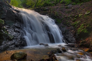
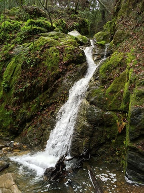
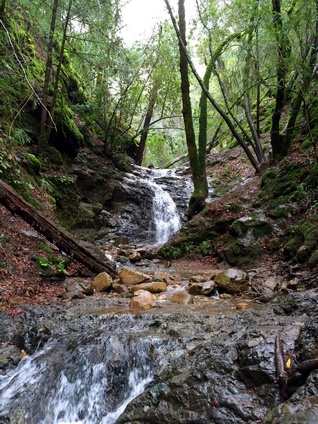
Uvas Canyon County Park is a spectacular park nestled in upper Uvas Canyon on the eastern side of the Santa Cruz Mountains. Although located only 30 minutes from San Jose, this lushly wooded 1,133 acre park is remote and serene. The park offers about seven miles of hiking trails, in addition to picnicking and camping. The park is best known, however, for its many waterfalls. Uvas Canyon County Park features at least seven waterfalls, in addition to numerous other cascades along the Uvas, Alec, and Swanson Creeks. The waterfalls are seasonal, and are at their peak in the winter or early spring after a heavy rain. The park also features the 2,694' Knibbs Knob, accessible via an extremely steep trail that climbs 1,600' in only 1.6 miles!
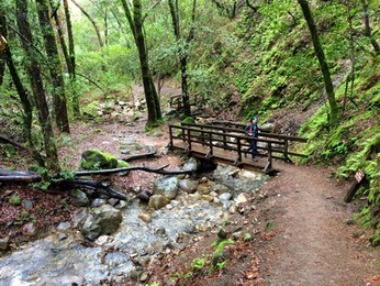
The trails in Uvas Canyon County Park are a mix of old dirt roads and singletrack trails. The trails are moderate, except for the very steep Knibbs Knob Trail. Elevations in the park range from about 1,000' at the park entrance to about 2,700' at Knibbs Knob. The trails are generally shaded, although this area of the Santa Cruz Mountains can get very hot in the summer! Note that a few of the trails cross creeks and may be flooded after heavy rains.
Uvas Canyon County Park is accessed via Croy Road, which passes through the private, unincorporated community of Sveadal. Since its founding in 1926, Sveadal has been owned and operated by the Swedish American Patriotic League, a congress of local organizations, dedicated to promoting and perpetuating common Swedish-American heritage in the San Francisco Bay Area.
The heavy rains during the winter of 2016/2017 caused a road wash-out that forced the closure of the entire park. The park was reopened in the spring of 2018, but there are still occasional closures for construction work. Please refer to the official park site for more details.
 Along the Waterfall Loop Trail
The Dirt:
Extras:
- Click here for a printable map of the Favorite Runs below!
- Click here for the official park site with trail map.
- Click here for driving directions to the parking area via Google Maps.
- Dogs on leash are allowed on ALL TRAILS in the park!
Extras:
- The only drinking water available in the park is in the main parking lot at the start/finish.
- Note that there is a fee to enter the park.
- Uvas Canyon County Park features reservable individual and group campsites with showers if you'd like to stay overnight in the park.
Favorite Run #1: Grand Tour Loop (6.6 mi, ~1600 feet elevation gain) 🐾
|
This route takes you past every waterfall in the park and along almost every trail, except for the Knibbs Knob Trail (see Favorite Run #2). It features a main loop with multiple out-and-back spurs to see the various waterfalls and lookouts. The first half of the loop follows the Swanson Creek where most of the waterfalls area located, and includes a short out-and-back climb to Knobcone Point. The second half follows the Contour and Alec Canyon Trails and includes a side trip to the Old Logging Camp and Triple Falls.
The route starts from the main parking lot. To begin, head uphill past the bathrooms along the paved road. GPX Track Printable Trail Map Driving Directions |
|
Route Details:
|
Lower Falls
Upper Falls
|
Favorite Run #2: Knibbs Knob Climb (4.0 mi, ~1600 feet elevation gain) 🐾
|
This route follows a dirt road up to 2,694' Knibbs Knob. The key word is "up", since this route climbs about 1,600' in less than two miles. The climb is a real workout, but you are rewarded with spectacular views along the way. The summit itself is not spectacular, but the feeling of accomplishment is enough to make it all worthwhile, right?
The route starts from the main parking lot. To begin, head uphill past the bathrooms along the paved road. GPX Track Printable Trail Map Driving Directions |
|
Route Details:
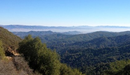 The view from Knibbs Knob Trail
- 0.0 mi: From the main parking lot, head uphill past the bathrooms on the paved road. You will soon get to a fork in the road with a sign. Veer right toward the Upper Bench Youth Group Area. Stay on the paved road for the next quarter-mile.
- 0.2 mi: Turn left toward Knibbs Knob Trailhead. Then just stay on the Knibbs Knob Trail as it climbs steeply to Knibbs Knob. Don't forget to check out the views behind you as you climb!
- 1.8 mi: Turn right toward Knibbs Knob.
- 2.0 mi: At 2,694' Knibbs Knob! Take a break, then retrace your steps back to your car.
- 4.0 mi: Back at your car!
Favorite Run #3: The Combination Run (10.6 mi, ~3200' elevation gain) 🐾
This challenging route hits every trail in the park! To do this run, simply combine Favorite Run #1 and Favorite Run #2 in either order!