Wildcat Canyon Regional Park
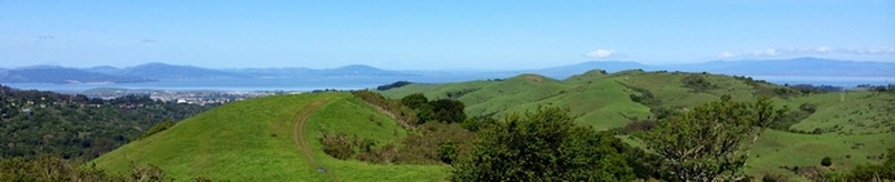
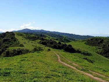
Wildcat Canyon Regional Park is located in the East Bay hills directly east of El Cerrito. The park offers 25 miles of trails through over 2,400 acres of open grassland and forest. The rolling San Pablo Ridge offers spectacular views of the Bay, San Francisco, and Marin. The park also includes a significant portion of the paved Nimitz Way which starts at Inspiration point in Tilden Regional Park and runs south along the ridge approximately 4 miles. Easy access from the busy cities of the East Bay makes Wildcat Canyon a popular place for hikers, runners, mountain bikers, and equestrians.
The trails in Wildcat Canyon Regional Park are mostly fire roads and, as is the case is most East Bay Parks, dogs are allowed on the trails. The trails are well-marked and well-maintained. Be careful of cow poop, though, since cattle do graze within the park boundaries. The elevations in the park range from about 200' at the park entrance to just over 1000' along the ridge, and the climbs are fairly mild. Because of the mild climbs and well-marked trails, Wildcat Canyon is an excellent place for a beginner to experience trail running!
For those wanting a longer run, Wildcat Canyon connects to Tilden Regional Park to the south via the Wildcat Creek Trail or the paved Nimitz Trail. In fact, a 30+ mile one-way run is possible along the Bay Area Ridge Trail by connecting Wildcat Canyon, Tilden, Sibley Volcanic, Huckleberry, Redwood, and Chabot Park (see this run for example).
There are multiple trailheads for Wildcat Canyon Regional Park. All of the runs on this page start from the Wildcat Creek Trailhead staging area at the north end of the park.
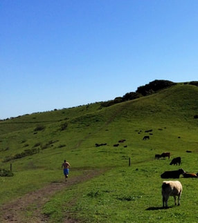 Runner on San Pablo Ridge Trail
The Dirt:
Extras:
- Click here to download a printable map of the Favorite Runs below!
- Click here for the official website with a link to the trail map.
- Click here for driving directions to the Wildcat Creek Trailhead staging area via Google maps.
- Dogs are allowed, and may be off-leash away from trailheads, parking lots, and areas marked as on-leash only. Refer to the East Bay Regional Park page on Dogs for more information. Note that dogs are NOT allowed in the adjoining Tilden Nature Area.
Extras:
- Wildcat Canyon Regional park connects to Tilden Regional Park to the south via the Wildcat Creek Trail or Nimitz Way.
- Sections of the Bay Area Ridge Trail pass through Wildcat Canyon Regional Park.
- There is drinking water available near the intersection of the Wildcat Creek Trail and Mezue Trail.
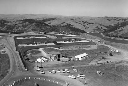
The Story of Nimitz Way, Nike Missle Bases, and the Cold War
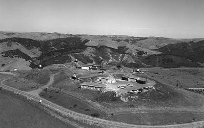 Nike radar site at the north end of Nimitz Way, circa 1959
Now a paved recreational trail, the 4-mile long Nimitz Way has a fascinating history. The trail is named after Admiral Chester W. Nimitz and was constructed as an access road for the Nike missile and radar sites that once operated in the hills of what is now Wildcat Canyon Regional Park. Believe it or not, the Bay Area was once home to many missile sites designed to protect us against the threat of the Soviet Union during the Cold War!
In the Cold War aftermath of World War II, military planners were afraid of Soviet Union bombers attacking undefended U.S. urban centers and military installations. By 1946, the United States had developed the Nike-Ajax missile, the nation’s first supersonic anti-aircraft guided missile. By 1953, Nike missile bases were operational around vital industrial areas and densely populated strategic areas. Twelve Nike missile bases encircled the Bay Area, beginning with the first base in San Francisco in 1954. By 1959, the area that would become today’s Wildcat Canyon Park was home to a Nike missile installation consisting of 24 Nike-Ajax guided missiles and a radar site with six radars. Nimitz Way was then the carefully guarded entrance to the installation complex.
In the Cold War aftermath of World War II, military planners were afraid of Soviet Union bombers attacking undefended U.S. urban centers and military installations. By 1946, the United States had developed the Nike-Ajax missile, the nation’s first supersonic anti-aircraft guided missile. By 1953, Nike missile bases were operational around vital industrial areas and densely populated strategic areas. Twelve Nike missile bases encircled the Bay Area, beginning with the first base in San Francisco in 1954. By 1959, the area that would become today’s Wildcat Canyon Park was home to a Nike missile installation consisting of 24 Nike-Ajax guided missiles and a radar site with six radars. Nimitz Way was then the carefully guarded entrance to the installation complex.
 Nike launch site where Conlon Road meets Nimitz Way, circa 1959
The Nike radar site was accessed by following Nimitz Way north from Inspiration Point for four miles (where the pavement ends today). The Nike missile launching pads themselves were just over two miles north of Inspiration Point (near the intersection with the Conlon Trail today). Most of the Nike missile base installations stretched over several miles, since it was required that the radar be located well away from the launch site. Because of their line-of-sight requirement, the bases usually had sweeping vistas of the area where they were located. This helps explain their popularity as Regional Parks today. In addition to the radar buildings and missile launch and storage facilities, each site had administration buildings, housing, and even guard-dog kennels and training facilities. Each site had a round-the-clock military presence with dozens of military personnel.
Most of the Nike missile bases in the Bay Area had a brief lifespan. By 1962 they were already being deactivated as changing military technology made attack from long-range bombers unlikely. By 1974, the last of the four remaining Nike missile bases in the Bay Area had closed. The Wildcat Canyon Nike installation’s administration and housing buildings were torn down; the missile launch and storage facilities were filled in with dirt. Its associated radar installation on Potrero Ridge was also torn down. All that now remains of our area’s supreme Cold War contributions are the Nimitz Way access road, the radar site’s old cement pads, and the expansive unobstructed views of the Bay Area; views which were, no doubt, a major factor in the military placing these Nike sites where they did. (Adapted from a story in the El Cerrito Forge).
Today, all but one of the Nike missile sites in the Bay Area have been demolished, fallen into disrepair, re-purposed, or are closed to the public. However, site SF-88 at Fort Barry in the Marin Headlands has been restored by the National Park Service and volunteers, and is open to the public for tours. For more information, check out the Marin Headlands page.
Favorite Run #1: Havey Canyon Loop (7.2 mi, ~1100 feet elevation gain) 🐾
|
This is a really nice intro loop that hits many of the highlights in Wildcat Canyon Regional Park. The first two miles are along the shaded Wildcat Creek Trail, which gives you a great warm-up for the climb up the wooded Havey Canyon Trail. The climb is tough but well worth the effort because the views from the ridge are spectacular. The route then heads north along the paved Nimitz Way, past the old Nike radar site, and then along the San Pablo Ridge trail for some more amazing views of the Bay, San Francisco, and Marin. Finally, you descend the Belgum Ridge Trail and head back to your car.
The run starts from the Wildcat Creek Trailhead. To begin the run, head up the well-marked Wildcat Creek Trail. GPX Track Printable Trail Map Driving Directions |
|
Route Details:
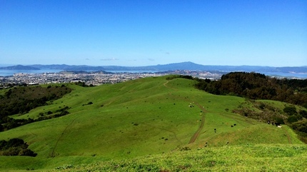
 The San Pablo Ridge Trail
- 0.0 mi: From the parking area, head south along the Wildcat Creek Trail. This trail is initially paved but soon turns to a dirt road.
- 2.2 mi: You will pass a bridge on your right. Just past this bridge, turn left onto the Havey Canyon Trail and start the 1.5-mile climb.
- 3.7 mi: Havey Canyon Trail ends. Turn left onto the paved Nimitz Way.
- 4.1 mi: Pass the abandoned Nike radar site on your right side (you should see the old cement foundations on top of the hill). The trail now turns to dirt and becomes the San Pablo Ridge Trail.
- 4.4 mi: Just past the cattle pen, veer left to stay on the San Pablo Ridge Trail. Enjoy the views as you roll along the ridge.
- 5.7 mi: San Pablo Ridge Trail ends. Veer left onto Belgum Trail and start descending. Stay on Belgum Trail until it ends at Wildcat Creek Trail.
- 6.7 mi: Turn right on the paved Wildcat Creek Trail to head back to your car.
- 7.2 mi: Back at your car!
Favorite Run #2: Wildcat Peak Loop (11.0 mi, ~1400 feet elevation gain)
|
This is a longer version of Favorite Run #1, adding in a portion of the Tilden Nature Area and a trip up to Wildcat Peak. Located on Wildcat Peak is the stone "Peace Grove Look-out" completed in 1962 by the Rotary Club of Berkeley. This look-out point gives you spectacular views of the Bay Area below.
The route first takes you along the entire length of the Wildcat Creek Trail, ending in Tilden Nature Area. Next, you'll have a great singletrack climb through a eucalyptus grove and forested hillside on the Wildcat Peak Trail. After enjoying the view from the "Look-Out," you'll follow Nimitz Way past the old Nike missile and radar sites to intersect the San Pablo Ridge Trail. The final part of the run is a mile-long descent back down to the Wildcat Creek Trail. Dogs are NOT allowed in Tilden Nature Area. GPX Track Printable Trail Map Driving Directions |
|
Route Details:
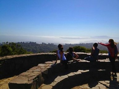 The stone "Peace Grove Look-out" at Wildcat Peak
- 0.0 mi: From the parking area, head south along the Wildcat Creek Trail. This trail is initially paved but soon turns to a dirt road. Follow Wildcat Creek Trail for the next 4 miles.
- 3.4 mi: Enter Tilden Nature Area. Stay on Wildcat Creek Trail.
- 4.1 mi: Just before Jewel Lake, turn left on the singletrack Jewel Lake Trail toward Sylvan & Wildcat Peak Trails. In about 200 feet, veer left to continue climbing up Sylvan Trail toward Wildcat Peak Trail.
- 4.5 mi: Turn left and continue climbing up Wildcat Peak Trail. In about 1/2 mile you will see some unofficial trails heading straight up to the peak. Avoid erosion and continue up the official "switchbacky" trail to the top.
- 5.3 mi: Pass a small unmarked singletrack on your left. Continue on the main trail to the "Peace Grove Look-out."
- 5.5 mi: Take a sharp left turn and follow the trail 100 feet up to the "Look-out." Enjoy the view and then head back 100 feet to the Wildcat Peak Trail and continue the way you were heading toward Nimitz Way.
- 5.8 mi: Turn left on Nimitz Way.
- 6.2 mi: At the intersection with Conlon Trail. The meadow to your right is the old Nike missile site. After picturing how this site looked 50 years ago, continue on Nimitz Way.
- 8.0 mi: Pass the abandoned Nike radar site on your right side (you should see the old cement foundations on top of the hill). The trail now turns to dirt and becomes the San Pablo Ridge Trail.
- 8.3 mi: At the cattle pen, veer left and then veer right to stay on the San Pablo Ridge Trail. Enjoy the views as you roll along the ridge.
- 9.5 mi: San Pablo Ridge Trail ends. Veer left onto Belgum Trail and start descending. Stay on Belgum Trail until it ends at the paved Wildcat Creek Trail.
- 10.6 mi: Turn right on the paved Wildcat Creek Trail to head back to your car.
- 11.0 mi: Back at your car!