Big Sur Coast & Ventana Wilderness of the Los Padres National Forest
The Ventana Wilderness is part of the expansive Los Padres National Forest, which comprises almost 2 million acres stretching 220 miles from mid-Monterey County all of the way south to the western boundary of Los Angeles County. Within the Los Padres National Forest are ten designated wilderness areas comprising about half of the forest. These include the Ventana, Silver Peak, Santa Lucia, Machesna, Garcia, San Rafael, Dick Smith, Sespe, Matilija, and Chumash wildernesses. The Ventana Wilderness contains over 200,000 acres, including the spectacular Big Sur Coast.
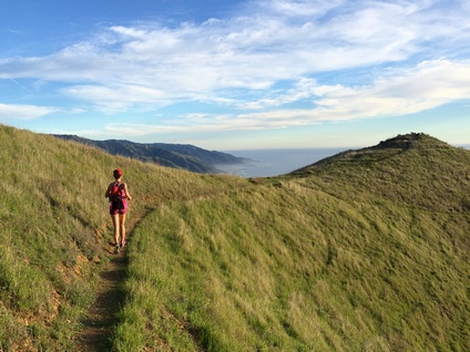
There are over 1,200 miles of trails in the Los Padres National Forest. Because there are almost no roads that running through the forest, most of the inland trails are remote and little used. There are a multitude of amazing ridges, peaks, and canyons that take days to reach on foot. Routes in Los Padres National Forest and along the Big Sur coast are made even more challenging by the dramatic elevation change, and elevations in the forest range from sea level to over 8,000 feet. However, those that are up for the challenge are rewarded with amazing raw wilderness and dramatic views of the Pacific Ocean and the inland peaks and valleys.
The Ventana Wilderness adjoins many state parks along the coast. These include: Andrew Molera State Park, Pfeiffer Big Sur State Park, Julia Pfeiffer Burns State Park, and Limekiln State Park. Many trails in these parks connect with trails in the Ventana Wilderness and make excellent starting points for adventures into the forest.
In addition to hiking and trail running, the Ventana Wilderness is a popular area for backpacking. There are many designated campsites in the forest. Please refer to the Los Padres National Forest website for information on permits and availability. The spring wildflower displays in the forest, which typically are at their peak in March or April, are truly spectacular.
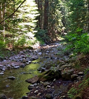 The Little Sur River
The Dirt:
Extras:
- Visit the official Los Padres National Forest website for information on maps, camping, and contact information for the Ranger Districts.
- National Geographic publishes an excellent and comprehensive Trail Map of Big Sur - Ventana Wilderness. You can purchase the map from the Trailstompers Store!
- There are dozens of trailheads for the forest, so driving directions are listed with each Favorite Run below.
- The Big Sur Coast is a hot spot for poison oak. Click here to learn about preventing and treating poison oak rashes.
- Dogs are allowed on ALL TRAILS in the wilderness!
Extras:
- There are several excellent web resources for hiking in the Ventana Wilderness, including VentanaWild.org and HikeLosPadres.com.
- For more information specific to the Big Sur area, check out HikingInBigSur.com, RedwoodHikes.com, and BigSurCalifornia.org.
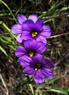 Blue Eyed Grass in Big Sur
Important notes and warnings: The Ventana Wilderness and Big Sur Coast is a real wilderness area. The trails are remote and rugged, and it is not uncommon to go an entire day without seeing another human being. Here are some safety tips for planning your visit:
- Trails that are shown on the map may be narrow and overgrown, or no longer exist. It's a good idea to check current trail conditions with a ranger before attempting a long route through the forest.
- You will see very few people in the forest, and there is no cell phone reception, so it is better to go with a group or carry a Personal Locator Beacon or Satellite Messenger in case you run into trouble.
- There is no potable drinking water in the forest. There are streams that may be flowing depending upon the season. Check with a ranger before assuming a stream will be flowing, and use a water filter or other purification device.
- There are lots of ticks in the forest, so plan on picking up ticks as you walk through the brush. Check yourself often and pick them off before they sink their little jaws into your skin. There is also a lot of poison oak in the forest, so be sure to wash thoroughly after your adventure!
- It is helpful to wear long pants or long socks to protect your legs from the ticks, poison oak, and other scratchy things that tear up your shins as you hike or run through the overgrown trails.
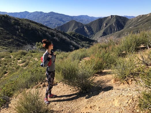
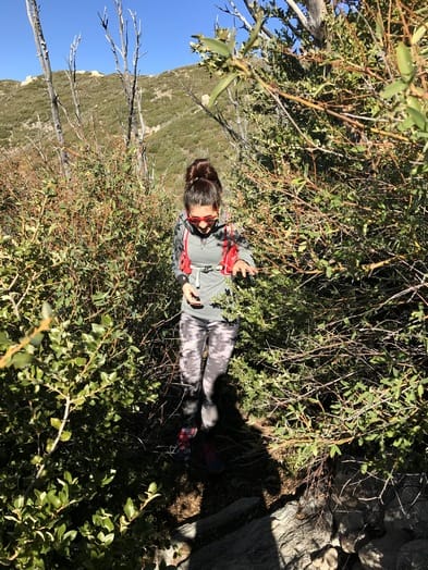
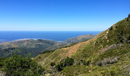
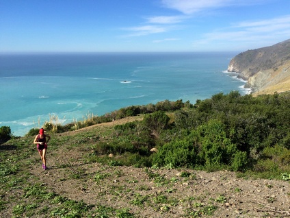
Favorite Run #1: Post Summit (9.0 mi, ~3400 feet elevation gain)
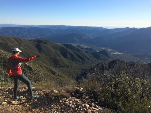
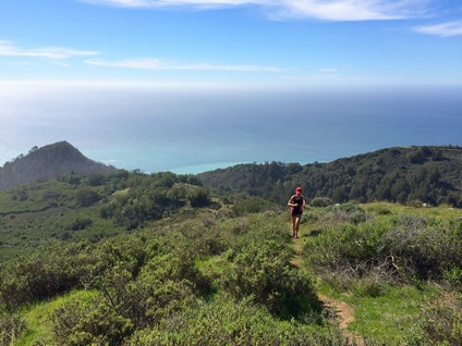
 Grand view from Post Summit
This route starts in Andrew Molera State Park and follows the narrow and relatively unmaintained East Molera Trail up to the ridge where there are spectacular views of 3,709-foot Pico Blanco, a solid limestone mountain in the Los Padres National Forest. The trail then rolls along the ridge before turning sharply east for a very steep and loose climb up to 3,455-foot Post Summit for amazing 360-degree views.
Because this route starts in Andrew Molera State Park, it is described on the Andrew Molera State Park trail running page. Because this route passes through Andrew Molera State Park, there are no dogs allowed.
Because this route starts in Andrew Molera State Park, it is described on the Andrew Molera State Park trail running page. Because this route passes through Andrew Molera State Park, there are no dogs allowed.
Favorite Run #2: Pico Blanco Summit (14.4 mi, ~3500 feet elevation gain) 🐾
|
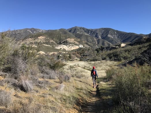
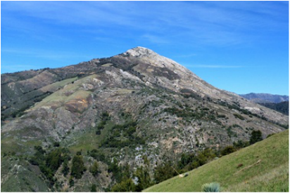
Pico Blanco, Spanish for "White Peak," is one of the most distinctive peaks in the Big Sur area. The 3,709' peak is a prominent white limestone cone seen from the Ventana Trail and nearby East Molera Trail and Post Summit. The views from the summit are spectacular, with the expansive Pacific Ocean to the west, Ventana Double Cone and Kandlbinder Peak to the the southeast, as well as many other Big Sur peaks including Mount Manuel, Post Summit, and Cone Peak.
Pico Blanco is reportedly the largest limestone deposit in the state. In fact, In 1963 the Granite Rock Company of Watsonville purchased Pico Blanco Mountain for the purpose of mining the limestone. Despite a 20-year court battle, there is no active mining on the mountain today. The route to the summit is an out-and-back. The first two miles on the narrow Little Sur Trail follow the pretty Little Sur River through a dense evergreen forest. The trail then intersects an old dirt road which you follow almost all of the way up the summit. This old road was cut into the mountain for the purpose of mining the mountain's limestone. The last 400' are a scramble up a steep slope to the peak. |
|
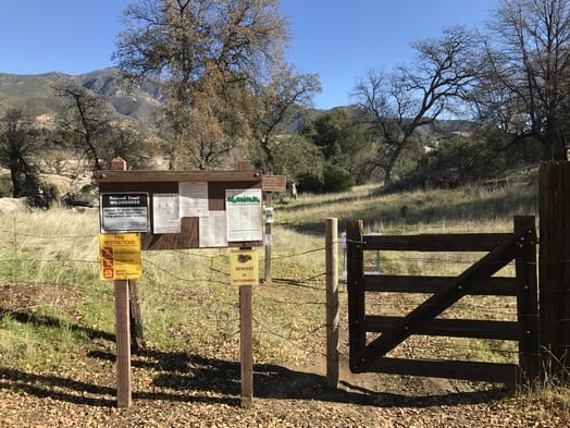
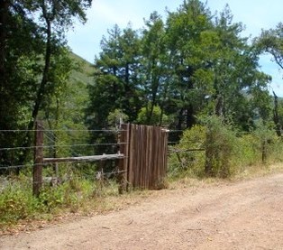 Unmarked gate at the Little Sur Trailhead
The trailhead for the Little Sur Trail is on the Old Coast Road. This rough 10-mile dirt road was the only road through Big Sur before Highway One was constructed in the 1930's. Four-wheel drive vehicles are strongly recommended but are not required. Note that the road may be closed seasonally due to storm damage. The Old Coast Road intersects Highway One in two places. The Little Sur Trailhead is located approximately 3.8 miles from the southern end of the Old Coast Road and 6.2 miles from the northern end of the road.
Note that the trailhead is an unmarked wooden gate and is very easy to miss! If you are driving in from the southern end of the Old Coast Road, the trailhead will be on your right side, about 0.2 miles before the road drops down alongside the Little Sur River.
GPX Track
Printable Trail Map
Driving Directions
|
Route Details:
Disclaimer: The last few miles of the route are on private property, owned by the Granite Rock Company, so a trip up to Pico Blanco summit is technically trespassing. But, many people still undertake this route because of the spectacular views from the 3,709' summit. We have heard that there is a caretaker that may escort you off of the trail if you are caught.
|
Pico Blanco (from the East Molera Trail)
Spectacular view from Pico Blanco summit
|
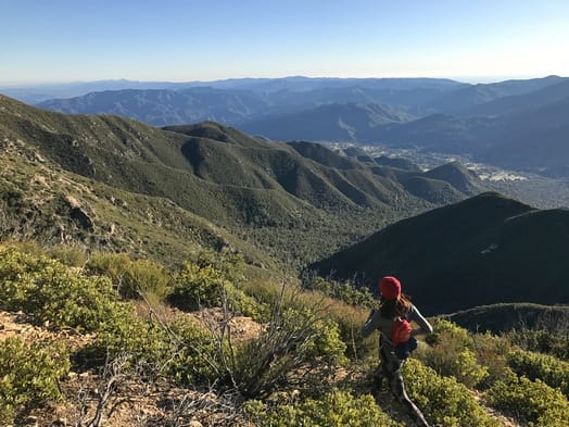
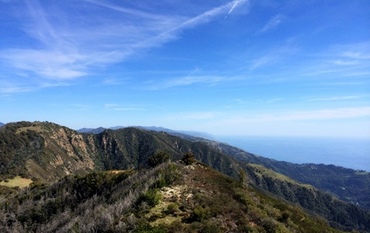
Favorite Run #3: Cone Peak Summit (16.6 mi, ~5800 feet elevation gain!) 🐾
|
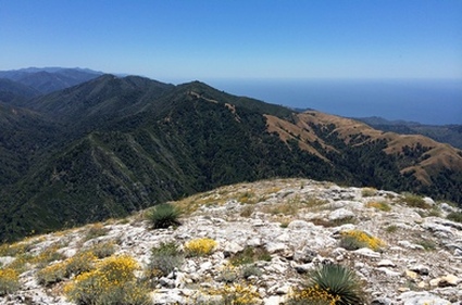
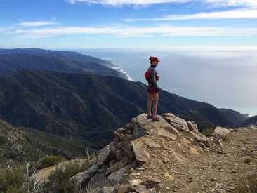
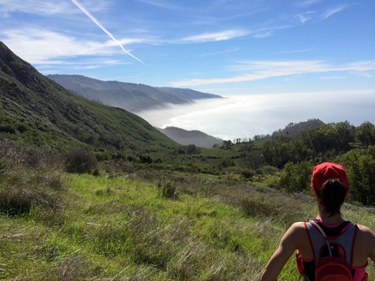
Cone Peak is generally considered the most spectacular mountain on the Big Sur coast of California. It is the second highest mountain in the Santa Lucia Range. The 5150' summit is located only three miles from the ocean. This extreme elevation change means stunning views of the Pacific Ocean and the surrounding wilderness.
There is a trailhead located along the Central Coast Ridge Road that is only 3 miles from the summit; however, that's not the exciting way to go! The route described here starts along Highway 1 and reaches the summit in 8.3 miles with some very steep sections. Along the way you will cross at least two creeks (depending upon the recent rains), pass through a redwood forest, tackle innumerable switchbacks, and be rewarded with nonstop spectacular awe-inspiring views. Note that the route described here follows "official" trails to the summit. However, there is an alternative route starting at mile 2.4 that follows the ridgeline all of the way to the summit. This route is a couple of miles shorter but is extremely steep, earning it the name "Sea-to-Sky Route." This route is not described here, but you can easily find directions by doing a Google search for "cone peak sea to sky". |
|
|
The route starts from a dirt pull-out along the west side of Highway 1. The trailhead is unmarked but is easy to find. Heading south from Big Sur, continue approximately 25 miles to the tiny town of Lucia. The large dirt pull-out is located about 1.4 miles past the Lucia Lodge on the right side. If you reach the tunnel, you've gone too far.
GPX Track Printable Trail Map Driving Directions Route Details: |
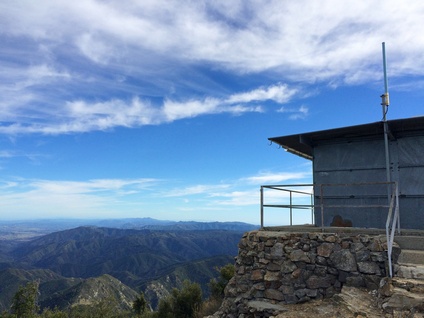
The view from Cone Peak
|
- 0.0 mi: From the dirt pull-out, cross over Hwy 1 and start up the very steep old dirt Twitchell Road (note there are no signs indicating the name of the trail).
- 0.4 mi: At the top of the first ridge, Twitchell Road intersects the Alvin Trail. Stay left on Twitchell Trail, which is very overgrown the next quarter-mile. The next section passes through a beautiful redwood gulch.
- 0.9 mi: Cross over Limekiln Creek, and then get ready for some crazy climbing!
- 1.6 mi: Start of the "Twitchell Elevator", which climbs over 1100' in 0.8 miles!
- 2.4 mi: The trail follows an old fence on the right side. Just past the fence, you'll reach a high spot with great views. Just after, the trail splits three ways: Take the far left fork onto Stone Ridge Trail. The next two miles are not as steep, and you will actually descend for a bit. (Note that the less-distinct middle fork is an alternate direct route to Cone Peak that follows the ridgeline to Twin Peak and then Cone Peak. This route is a couple of miles shorter; however, it is EXTREMELY STEEP! Check out the printable trail map for an overview of the direct ridge route.)
- 3.9 mi: The trail crosses a small creek. Shortly after, you will pass the cut-off trail to Goat Camp. Stay right on Stone Ridge Trail toward Gamboa Trail. The next 1.5 miles is a series of switchbacks that climb over 900'.
- 5.5 mi: At the top of the pass! Turn right onto Gamboa Trail toward Cone Peak.
- 6.9 mi: At Trail Spring Camp. When you reach the stream, turn right onto Cone Peak Trail toward Cone Peak Lookout. You're only 1.4 miles from the summit, but still have 1000' of climbing!
- 8.1 mi: The trail opens up to spectacular views!! Turn left on the trail toward the Cone Peak Lookout.
- 8.3 mi: At the summit of 5148' Cone Peak! The summit has a metal building with a walkway that provides a great place to sit and enjoy the amazing views! After you've taken in the view, retrace your steps back to your car.
- 14.2 mi: Back at the 3-way split. This is the one place on the way back down that is confusing. Just after passing the 3-way intersection, you need to veer right, even though the trail looks like it continues straight. Don't worry, if you go straight by accident the trail will soon end and you'll know you went the wrong way!! The next 1.5 miles on the Twitchell Elevator are very steep and loose, so be careful and watch your footing!!
- 15.7 mi: Cross over Limekiln Creek and climb up to the final ridge.
- 16.6 mi: Back at your car!
Starting up Twitchell Rd from Hwy 1
Near the top of the Twitchell Elevator
The lookout at the top
|
At 1.5 miles in the views are already amazing!
The 3-way split at mile 2.4; Go LEFT
Confusing spot on the way down... Veer RIGHT ahead!
|
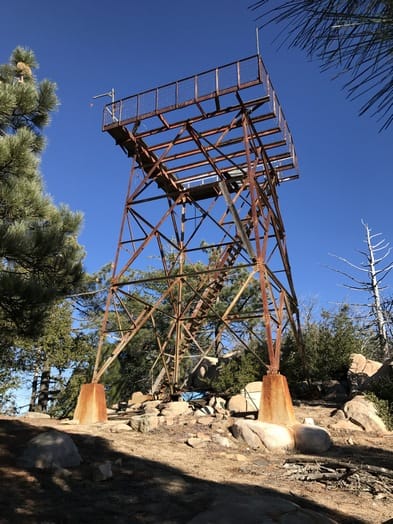
Favorite Run #4: Junipero Serra Peak (12.0 mi, ~3800 feet elevation gain!) 🐾
|
At an elevation of 5,857', Junipero Serra Peak is the highest peak in the Santa Lucia range. The peak is located about 40 miles southeast of Monterey, surrounded by the Ventana Wilderness. The peak is accessed via a 6-mile climb on the Santa Lucia Trail, which begins at Santa Lucia Memorial Park Campground. This area of the Ventana Wilderness is stunning, with unique sandstone rock formations and rugged mountain vistas. The trail is moderate for the first two miles; however, the last four miles to the summit are really tough. The trail is steep, overgrown, and difficult to follow in some places. However, the views along the trail are amazing and well worth the effort. At the peak you will encounter an old fire lookout tower. The wooden floor of the lookout is completely gone, but you can still climb the old stairs for better views. The actual summit is located about 500 feet southeast of the lookout and has some old cement structures, one of which contains a hidden log book as of 2016. Note that Junipero Serra Peak is located inland and views of the Pacific Ocean are blocked by the coastal mountains. If you are seeking ocean views, you probably want to climb one of the peaks listed above (Cone Peak, Pico Blanco, or Post Summit).
|
|
|
Getting to the trailhead can be as much of an adventure as the trail itself, since the drive to the trailhead involves driving through a U.S. Army Garrison and then driving through two creek crossings (yes, you actually drive your car through the creek!). When entering Fort Hunter Liggett, all members of your party may be required to show photo ID. Just to make things even weirder, the creek crossings are closed when the creek is high. In this case there is an alternate route to the trailhead, described below.
Getting to the trailhead:
|

Entering Fort Hunter Liggett
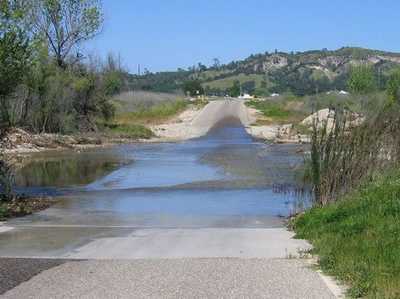
Creek crossing on Del Venturi Road
|
GPX Track
Printable Trail Map
Driving Directions
Route Details:
Note: The trail is overgrown in places and is full of ticks and poison oak. We'd recommend wearing long pants and a long-sleeve shirt!
Printable Trail Map
Driving Directions
Route Details:
Note: The trail is overgrown in places and is full of ticks and poison oak. We'd recommend wearing long pants and a long-sleeve shirt!
- 0.0 mi: From the dirt parking area at Santa Lucia Memorial Park Campground, head back along Indians Road the way you drove in.
- 0.1 mi: Turn left to access the Santa Lucia Trailhead. The first mile gradually climbs through a valley filled with bizarre sandstone rock formations.
- 1.7 mi: Pass an old rusty tractor and continue on Santa Lucia Trail. The trail starts climbing more aggressively now.
- 3.1 mi: Start of the steep switchback section.
- 3.7 mi: Top of the first ridge. Turn right to continue on Santa Lucia Trail. The trail becomes more overgrown as you climb, but the views are spectacular!
- 5.3 mi: Top of the second ridge. The trail veers right and continues up to the peak.
- 6.0 mi: At the fire lookout tower. The actual peak is about 500 feet to the southeast, where you will find some old cement structures and a sign-in book. There are plenty of large rocks here to sit down and take a break while enjoying the view. After resting, return to your car the same way you came up.
- 12.0 mi: Back at your car!