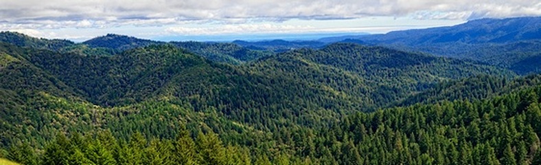
Castle Rock State Park
Castle Rock State Park is located in the Santa Cruz Mountains near the intersection of Hwy 9 and Skyline Blvd, southwest of Saratoga. The park is comprised of over 5,200 acres of redwood, fir, and madrone forest, in addition to over 30 miles of stellar trails. The trails are part of an even more extensive trail system that links the Santa Clara and San Lorenzo valleys with Castle Rock State Park, Big Basin Redwoods State Park, and the Pacific Coast. Castle Rock is also the starting point of the Skyline-to-the-Sea Trail, a 26-mile trail that leads to Waddell Beach north of Santa Cruz. There are also two walk-in campgrounds within the park for overnight backpacking.
The trails in Castle Rock State Park are some of the best in the South Bay area. One trail of particular historical interest is the Saratoga Toll Road Trail, which begins at Saratoga Gap and descends about 2000' over 6 miles into the San Lorenzo River valley where it eventually connects with Highway 9. The Saratoga Toll Road was completed in 1870 by the Saratoga and Pescadero Turnpike and Wagonroad Company to connect the two cities and allow transport of fruit, lumber, and wine. After the opening of the railroad in 1880, the use of the road gradually diminished, and in 1890 was deeded to the County of Santa Cruz. In the 1930's the lower part of the Toll Road was linked to Saratoga Gap via what is now Highway 9, which eliminated the need for the upper 6 miles of the Saratoga Toll Road. In 1984, the old Toll Road was re-purposed as a beautiful riding and hiking trail.
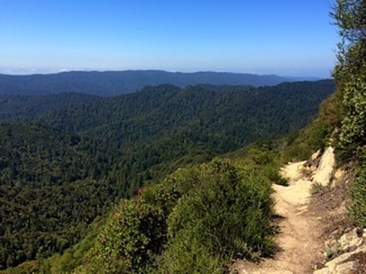
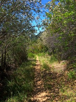
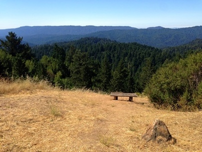
The trails in Castle Rock State Park range from smooth fire roads to rugged singletrack. Elevations in the park range from below 800' in the San Lorenzo River valley to over 3000' near the main park entrance. Because of the elevation rage, the park offers great trail running and hiking with moderate to lengthy climbs. The scenery in the park is spectacular: redwood and fir forests, deep valleys and canyons, and ridge-top vistas. The weather is most often moderate, although it can be very hot in the late summer. Even though many people visit the park, the trails feel remote and you can often run or hike for miles without passing a soul.
The trails in Castle Rock State Park are some of the best in the South Bay area. One trail of particular historical interest is the Saratoga Toll Road Trail, which begins at Saratoga Gap and descends about 2000' over 6 miles into the San Lorenzo River valley where it eventually connects with Highway 9. The Saratoga Toll Road was completed in 1870 by the Saratoga and Pescadero Turnpike and Wagonroad Company to connect the two cities and allow transport of fruit, lumber, and wine. After the opening of the railroad in 1880, the use of the road gradually diminished, and in 1890 was deeded to the County of Santa Cruz. In the 1930's the lower part of the Toll Road was linked to Saratoga Gap via what is now Highway 9, which eliminated the need for the upper 6 miles of the Saratoga Toll Road. In 1984, the old Toll Road was re-purposed as a beautiful riding and hiking trail.
The trails in Castle Rock State Park range from smooth fire roads to rugged singletrack. Elevations in the park range from below 800' in the San Lorenzo River valley to over 3000' near the main park entrance. Because of the elevation rage, the park offers great trail running and hiking with moderate to lengthy climbs. The scenery in the park is spectacular: redwood and fir forests, deep valleys and canyons, and ridge-top vistas. The weather is most often moderate, although it can be very hot in the late summer. Even though many people visit the park, the trails feel remote and you can often run or hike for miles without passing a soul.
|
The Dirt:
|
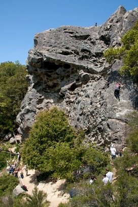
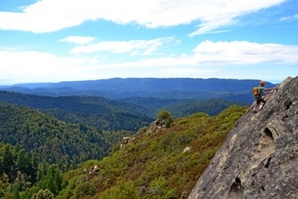
Climbers on Goat Rock
|
Favorite Run #1: Gap/Ridge Small Loop (4.8 mi, ~1000 feet elevation gain)
|
This loop is a great introduction to Castle Rock State Park. Even though the run is fairly short, you pass three highlights of the park: Castle Rock Falls, Goat Rock, and the southern part of the Saratoga Gap Trail. The Saratoga Gap Trail is very rocky and can be slow going, but the spectacular views from the trail are well worth the effort!
This run starts from the Castle Rock Main Entrance. From Saratoga Gap (junction of Hwy 9 and Skyline Blvd), head south on Skyline Blvd for about 2.5 miles. The Main Entrance will be on your right. There is a fee to park here. To start the run, head downhill from the parking lot, following the trail for Castle Rock Falls. GPX Track Printable Trail Map Driving Directions |
|
Route Details:
 The view from Saratoga Gap Trail... wowzers!
- 0.0 mi: Start heading downhill toward Castle Rock Falls.
- 0.5 mi: Junction with Ridge Trail. Stay left on the Saratoga Gap Trail to head toward Castle Rock Falls.
- 0.6 mi: At the falls overlook. Stop, admire the falls, then continue on Saratoga Gap Trail for two miles. You will pass the Connector Trail on your right, and then get ready for some great views! You will also pass a section where a cable has been installed as a handhold because the trail is narrow and tricky.
- 2.5 mi: Sharp right turn onto the Ridge Trail. You will climb for the next mile or so.
- 3.3 mi: Pass the Connector Trail on your right. Stay on the Ridge Trail.
- 3.6 mi: Stay right to continue on the Ridge Trail toward Goat Rock.
- 3.8 mi: At Goat Rock. Say 'hi' to the rock climbers, then continue down the steps on the Ridge Trail. Your climbing is mostly done.
- 4.3 mi: Intersection with the Saratoga Gap Trail. Cross the stream and turn left to head back up to the parking lot.
- 4.8 mi: Back at the car!
Favorite Run #2: Gap/Ridge Large Loop (13.0 mi, ~2300 feet elevation gain)
|
This loop is a challenging but beautiful run with some great climbing and excellent views. It incorporates the highlights of the previous run with a trip to Travertine Springs and a steady, moderate climb up Saratoga Toll Road. For this route we strongly recommend that you bring a trail map or download the GPX track to your GPS device, since some of the turns are confusing.
This run starts at the Saratoga Gap parking lot. To start the run, head south on the Skyline trail, which begins at the southeast side of the parking lot (the side of the parking lot opposite from Hwy 9). GPX Track Printable Trail Map Driving Directions |
|
Route Details:
|
Travertine Springs Trail
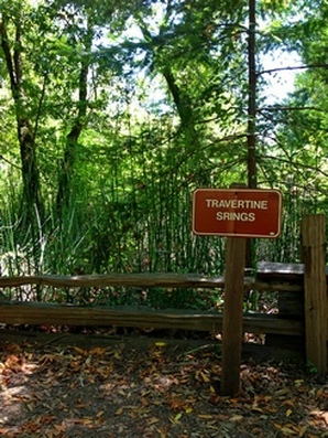
Wait... Travertine "Srings"??
|
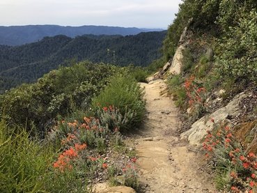
Flowers along the Saratoga Gap Trail
|
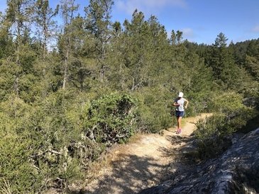
Sweet singletrack on Loghry Woods Trail
|
Favorite Run #3: Waterman Gap Super Loop (19.2 mi, 3100 feet elevation gain)
|
This run is the ultimate tour of the park, and not for the faint of heart! The route features an epic 9-mile climb up Saratoga Toll Road, Travertine Springs Trail, and Loghry Woods Trail, and ends with a rolling 7-mile descent on Skyline-to-the-Sea Trail back to your car. For this route we strongly recommend that you bring a trail map or download the GPX to your GPS device, as some of the trails are unmarked and confusing.
You could start this loop at Saratoga Gap, but we prefer to start at Waterman Gap so that the 7-mile descent is at the end of the run. From Saratoga Gap, continue westward on Hwy 9 toward Big Basin for about 6 miles. At the intersection of Hwy 9 and Hwy 236, turn right and park your car in the dirt parking area. Begin by running along Hwy 236 toward Big Basin, and then immediately turn left onto the Skyline-to-the-Sea Trail. GPX Track Printable Trail Map Driving Directions |
|
Route Details:
 The spectacular view from Skyline-to-the-Sea Trail
- 0.0 mi: Start out along Hwy 236 toward Big Basin. After a few hundred feet, turn left onto the Skyline-to-the-Sea Trail. Keep an eye out for the Skyline-to-the-Sea/Toll Road Interconnector Trail on your left.
- 0.5 mi: Turn left onto the Skyline-to-the-Sea/Toll Road Interconnector Trail. After an initial steep descent the trail will flatten out. After about 1/2-mile the trail will come out at a clearing under some high voltage power lines. Continue straight onto the narrow singletrack into the woods.
- 2.2 mi: Cross over Hwy 9 and head a bit to the left to continue on the Interconnector Trail. (Note: the trail on the other side of Hwy 9 is not marked well!)
- 2.4 mi: The trail ends on the Saratoga Toll Road, which is a well-maintained dirt road. Turn left and start climbing gradually. In a half mile, you will turn off of this road to stay on the Toll Road Trail.
- 3.0 mi: (CONFUSING INTERSECTION) You will come to a small clearing on the left, and see a narrow hiking trail turn off to your right. This is the Saratoga Toll Road Trail, although as of 2014 the sign was missing. Turn right onto the trail and start climbing. You will stay on the Toll Road Trail for 3.5 miles.
- 5.4 mi: Pass the Beekhuis Road Trail on your left. Continue on the Saratoga Toll Road, but keep an eye out for Travertine Springs Trail on your right.
- 6.5 mi: (EASY TO MISS) Turn right onto Travertine Springs Trail (singletrack). The turn is located just after a small landslide. Travertine Springs Trail is a great and challenging singletrack that first descends to the San Lorenzo Creek and then climbs back up to the Saratoga Gap Trail with spectacular views along the way. (Interesting factoid: The tiny San Lorenzo Creek turns into the big San Lorenzo River which flows through Felton and finally empties into the ocean in Santa Cruz.).
- 8.6 mi: Travertine Springs Trail ends at the Saratoga Gap Trail (fire road). Turn right onto the Saratoga Gap Trail and climb steeply towards the Castle Rock Trail Camp.
- 9.3 mi: At the Castle Rock Trail Camp. Head uphill (towards Skyline Blvd) on the Service Road Trail towards Loghry Woods Trail. Keep an eye out for Loghry Woods Trail on your left - it is very easy to miss!
- 9.4 mi: (EASY TO MISS) Turn left onto the Loghry Woods Trail. This is an awesome shaded singletrack climb up to Skyline Blvd.
- 11.2 mi: Cross over Skyline Blvd, and turn left onto the Skyline Trail, heading north toward Saratoga Gap. This trail parallels Skyline Blvd all of the way to Saratoga Gap.
- 11.3 mi: Stay right on the "Pedestrians Only" trail.
- 12.7 mi: Skyline Trail ends in the Saratoga Gap parking lot. Head to your left and cross over Skyline Blvd. Then start running down the left shoulder of Hwy 9 toward Big Basin. After a few hundred feet, veer left onto the Skyline-to-the-Sea Trail / Saratoga Toll Road Trail. The two trails will split in 1/2 mile.
- 13.2 mi: (EASY TO MISS) The Skyline-to-the-Sea Trail and Toll Road Trail split here. Turn right and climb up towards Hwy 9 to stay on the Skyline-to-the-Sea Trail.
- 13.3 mi: Cross Hwy 9, then turn left to continue on the Skyline-to-the-Sea Trail. Over the next 1.5 miles, you will pass several other trails, but continue to stay on the Skyline-to-the-Sea Trail. You will follow this trail for 6 miles all of the way back to your car!
- 14.7 mi: The trail comes out on a driveway. Run up the driveway, cross Hwy 9, and then veer right to continue on the Skyline-to-the-Sea Trail toward Waterman Gap. Over the next 4 miles, the trail will cross or temporarily follow several dirt roads, and it is easy to get on the wrong trail! Be careful to follow the signs for Skyline-to-the-Sea Trail!
- 18.8 mi: At the Waterman Gap Trail Camp. Turn right on the singletrack to continue on the Skyline-to-the-Sea Trail. There is a brief climb here.
- 19.1 mi: Cross Hwy 9, then turn left to continue on the Skyline-to-the-Sea Trail towards your car.
- 19.2 mi: Back at the car!