Henry W. Coe State Park
Henry W. Coe Park is the largest state park in northern California, with over 87,000 acres (135 square miles) of wild open spaces and about 250 miles of trails. The terrain of the park is rugged, varied, and beautiful, with lofty ridges and steep canyons. Even though the park is less than 30 minutes from San Jose, it is true wilderness. In fact, within Henry W. Coe Park is a designated wilderness area of about 22,000 acres known as the Orestimba Wilderness. This area is open only to hikers and requires a tough 10-mile hike from Coe Headquarters just to reach the western edge of the wilderness.
The headquarters for Henry W. Coe State Park is located on Pine Ridge, site of a working cattle ranch from the late 1800's until the early 1950's. Pine Ridge was one of two ranches owned by cattleman Henry W. Coe. His other ranch, San Felipe, was located east of San Jose. The cattle grazed at Pine Ridge in spring and summer when feed was abundant on the hills. In the fall they were driven back to the San Felipe Ranch. Henry W. Coe died in 1943. In 1953, Henry's daughter, Sada Coe Robinson, donated Pine Ridge Ranch to Santa Clara County to be preserved as a park in memory of her father. The land became a state park in 1958.
The trails in Henry W. Coe State Park are rugged and remote, and range from well-maintained dirt roads to almost nonexistent overgrown singletrack. Many of the trails are old ranch roads, created when the park was a working cattle ranch. In general, trails closer to the trailheads are more maintained, while interior trails may or may not be maintained. Elevations in the park range from under 1000' in the southern valleys to over 3500' at the northern end of the park. The climbs are generally very difficult, as many routes follow old roads that were built, apparently, without knowledge of a "switchback!"
Henry W. Coe was on the list of California State Park closures. Fortunately, money was "found" and the park will stay open for now! To help offset the costs, there are fees to use the park.
WARNINGS ABOUT HENRY COE:
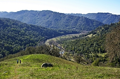
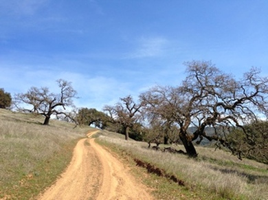
Mahoney Meadows Road: Classic Coe
|
Normally we don't post warnings about a park, but Henry Coe is a bit different. The park is beautiful, challenging, and remote. Do not underestimate how remote and challenging the trails are! Even though you are technically close to an urban area, you may as well be 100 miles away. Here are some things to keep in mind when you plan a run or hike in the park:
|
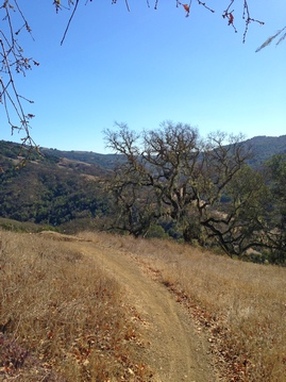
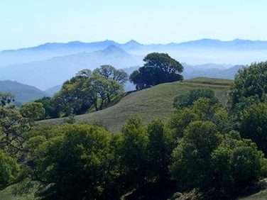 Gorgeous view from Steer Ridge
The Dirt:
Extras:
- Download a printable trail map of the Favorite Runs: North Side Map: Favorite Runs 1&2 or South Side Map: Favorite Runs 3&4!
- Click here for the official Henry Coe State Park site.
- Click here for the Pine Ridge Association site for Henry Coe.
- We strongly carrying a good trail map, which can be purchased from the headquarters or online. Click here for more details.
- Click here for driving directions to the main Coe headquarters. (If the main lot is full, you will have to park about 1/2-mile before the headquarters.)
- Click here for directions to the southern Hunting Hollow Entrance.
- Henry Coe is full of poison oak. Click here to learn about preventing and treating poison oak rashes.
- There are NO DOGS allowed in the park.
Extras:
- In addition to hiking, there are drive-in and hike-in campsites available, and backcounty camping. Please check with the park website for more details.
- Most trails in the parks also allow mountain bikes. The exceptions are several singletrack trails near the headquarters and the Orestimba Wilderness
- There is limited water in the park! There may be water that you can filter from Coyote Creek; however, check with the park office since the creek can dry up in the late summer. Several campgrounds may have tanks of potable water, but check with the visitor center to confirm!
- There are fees to use the park. Don't drive all of the way here and forget your cash!
Favorite Run #1: Middle Ridge/Poverty Flat Loop (11.1 mi, ~2200' elevation gain)
|
This loop is a shorter version of the "Huge Loop" described in Favorite Run #2 below. This is a challenging loop that takes you along the stunning Middle Ridge and down to Poverty Flat. Do not underestimate the climb out from Poverty Flat! But if you do this loop, you will be rewarded with some of the Bay Area's most remote scenery.
This loop starts from the main Coe headquarters. To begin the run, head up the paved access road toward Frog Lake. Note that, if the main parking lot is full, you will have to park about 1/2-mile from the headquarters in the overflow parking. This will add about 1 mile to the run. GPX Track Printable Trail Map Driving Directions |
|
|
Route Details:
|
Great singletrack on Flat Frog Trail
|
Favorite Run #2: China Hole Huge Loop (18.1 m, ~3500' elevation gain)
|
This loop is not for the faint of heart! It has massive climbs and descents, and over half of the route is on narrow singletrack trails. This loop is only 18 miles but it feels like a marathon! The best time for this run is in the spring or fall, not in the heat of summer. Before attempting this route, please read the warnings above about Henry Coe Park.
This loop starts from the main Coe headquarters. To begin the run, head up the paved access road toward Frog Lake. Note that, if the main parking lot is full, you will have to park about 1/2-mile from the headquarters in the overflow parking. This will add about 1 mile to the run. GPX Track Printable Trail Map Driving Directions |
|
Route Details:
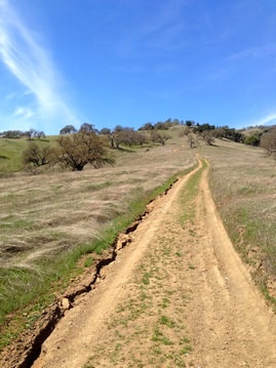
 Poverty Flat Road
- 0.0 mi: From Coe headquarters, head up the paved road toward Frog Lake. This will turn to dirt and start descending.
- 0.7 mi: Turn left onto Flat Frog Trail (singletrack).
- 3.0 mi: Just before the trail hits the dirt road, veer right to continue onto Frog Lake Trail (singletrack).
- 3.9 mi: Trail ends on Middle Ridge Trail. Turn right on Middle Ridge Trail (singletrack). Follow this trail for the next 3.6 miles as first rolls along the ridge and then steeply descends to Poverty Flat.
- 7.5 mi: Coyote Creek crossing at Poverty Flat. Merge onto the Poverty Flat Fire Road and continue east toward Los Cruzeros. You will cross the creek again and then start climbing steeply. Stay on the fire road for the next 1.5 miles.
- 9.0 mi: Turn right onto Mahoney Meadows Road and descend to Los Cruzeros. After crossing he creek you will start climbing.
- 9.8 mi: Turn right onto Lost Spring Trail (singletrack). Enjoy the shade while you're on this sweet climb.
- 10.7 mi: As soon as you hit Mahoney Meadows Road, take a sharp right onto China Hole Trail (singletrack). You will begin a long descent to China Hole.
- 12.9 mi: Creek crossing at China Hole. There is usually water in this creek, except during late summer or drought years. Take a break because the next 4 miles is climbing!! Cross the creek and continue on China Hole Trail. Stay on the main China Hole Trail all of the way to where it ends on Manzanita Point Road.
- 15.5 mi: China Hole Trail ends on Manzanita Point Road. Turn right and continue climbing through the campground.
- 16.2 mi: Turn left onto Springs Trail (singletrack). Do not take the left turn to Lion Spring.
- 17.5 mi: Continue onto Corral Trail toward the headquarters.
- 18.1 mi: Back at the headquarters!
Favorite Run #3: Wilson Camp Loop (12.9 mi, ~2600' elevation gain)
|
This run is a great tour of the southern end of Henry W. Coe State Park. The first part of this route takes you up the newly re-routed Jim Donnelly Trail. This trail used to be a very steep fire road, but in 2013 was turned into a well-graded singletrack with many switchbacks, adding over a mile but making the climb much more pleasant! After the climb, you are rewarded with stunning views from Steer Ridge. The trail then drops over 1000' to Coon Hunter's Gulch and climbs back up to Phegley Ridge. After a long descent, you follow Hunting Hollow Road back to your car.
This run starts from the southern Hunting Hollow Entrance. To begin the run, head around the gate and up the dirt road at the far end of the parking lot. GPX Track Printable Trail Map Driving Directions |
|
Route Details:
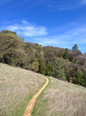
 The newly re-routed Jim Donnelly Trail
- 0.0 mi: From the far end of the dirt parking lot, head around the gate and onto the fire road. You will immediately cross a creek.
- 0.2 mi: Turn left on the Jim Donnelly Trail and start climbing. The next 3 miles is a long, gradual climb up to Steer Ridge.
- 3.2 mi: Jim Donnelly Trail ends at Steer Ridge Road. Follow Steer Ridge Road for the next 1.5 miles until it intersects with Wilson Peak Trail on the left.
- 4.7 mi: Turn left on Wilson Peak Trail to take a brief 0.1-mile detour to the peak.
- 4.8 mi: At 2651' Wilson Peak. Enjoy the view and then head back to Steer Ridge Road.
- 4.9 mi: Back at Steer Ridge Road. Turn left to continue in the direction you were heading. Follow Steer Ridge Road for the next 1.5 miles.
- 6.5 mi: Intersection with Wagon Road. Turn right to take a brief detour to Wilson Camp. You will find an old barn and house. Don't enter the house, as it is apparently infected with hantavirus. But, you will find a nice place to relax before your next big climb! After checking out Wilson Camp, continue on the loop trail back out to Wagon Trail. Turn right to continue descending to Coon Hunter's Gulch.
- 7.8 mi: Cross the creek and start climbing up to Phegley Ridge.
- 8.7 mi: At the top of the ridge, turn right onto Phegley Ridge Road. You will climb a little more and then head past Redfern Pond. The trail will soon start descending steeply. The last mile of the descent is narrow singletrack.
- 11.1 mi: Phegley Ridge Trail ends at Hunting Hollow Road. Turn right and follow this road all of the way back to your car.
- 12.9 mi: Back at your car!
Favorite Run #4: Grizzly Gulch Loop (12.4 mi, ~2200' elevation gain)
|
This is another great loop in the southern end of Henry W. Coe State Park. The first part of this route takes you up the newly re-routed Jim Donnelly Trail. This trail used to be a very steep fire road, but in 2013 was turned into a well-graded singletrack with many switchbacks, adding over a mile but making the climb much more pleasant! After the climb, you are rewarded with stunning views from Steer Ridge. The trail then drops into Grizzly Gulch and follows the beautiful and technical Grizzly Gulch Trail back out to the main road.
This run starts from the southern Hunting Hollow Entrance. To begin the run, head around the gate and up the dirt road at the far end of the parking lot. GPX Track Printable Trail Map Driving Directions |
|
Route Details:
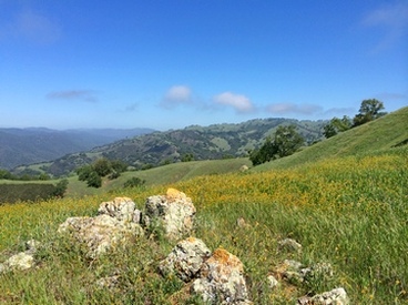 The view from Steer Ridge
- 0.0 mi: From the far end of the dirt parking lot, head around the gate and onto the fire road. You will immediately cross a creek.
- 0.2 mi: Turn left on the Jim Donnelly Trail and start climbing. The next 3 miles is a long, gradual climb up to Steer Ridge.
- 3.2 mi: Jim Donnelly Trail ends at Steer Ridge Road. Follow Steer Ridge Road for the next 1.5 miles until it intersects with Wilson Peak Trail on the left.
- 4.7 mi: Turn left on Wilson Peak Trail to take a brief 0.1-mile detour to the peak.
- 4.8 mi: At 2651' Wilson Peak. Enjoy the view and then head back to Steer Ridge Road.
- 4.9 mi: Back at Steer Ridge Road. Turn left to continue in the direction you were heading. Keep an eye out for Serpentine Trail on your left.
- 5.1 mi: Turn left on Serpentine Trail. This singletrack will descend steeply for the next mile to Grizzly Gulch.
- 6.0 mi: Trail ends at Grizzly Gulch Trail. Turn left and follow Grizzly Gulch Trail for the next 4 miles until it ends at Coit Road. Over the next 4 miles, the trail will follow the creek for a while, then climb up the side of the gulch, then descend back down to the creek. You will pass several side trails, but just stay on Grizzly Gulch Trail.
- 10.2 mi: Grizzly Gulch Trail ends at Coit Road. Veer left on Coit Road to head toward the Coyote Creek Entrance on Gilroy Hot Springs Road.
- 10.4 mi: Head around the gate and turn left on Gilroy Hot Springs Road (this is a paved road). Follow Gilroy Hot Springs Road for 2 miles back to the Hunting Hollow Entrance. Watch for cars on this narrow road!
- 12.4 mi: Turn left into the Hunting Hollow Entrance and head back to your car!