Pescadero Creek County Park and Portola Redwoods State Park
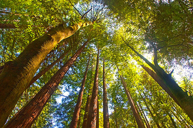
The Pescadero Creek Park Complex is a magnificent escape from the crowds of the Bay Area. The complex is comprised of four adjoining parks: Pescadero Creek County Park, Sam McDonald County Park, Memorial Park, and Portola Redwoods State Park. Together, they feature about 10,000 acres of redwood forest and dozens of miles of beautiful trails. Since the parks are about an hour drive from the Bay Area they are generally not crowded. The weather is usually mild because of the proximity to the coast and the shade of the redwood trees. This makes them a great place to run or hike year-round. It can be foggy and cold any time of the year, so we recommend bringing an extra layer just in case.
We are fortunate to have these parks available to us today. In the 1970's, the Army Corps of Engineers was going to construct a dam on Pescadero Creek creating a huge lake, flooding everything below 400 feet elevation. It was a massive plan that never happened due to the opposition of conservationists and anti-development factions. Since then, the parks have remained relatively undeveloped except for the small Ranger Station and extensive trail system.
We are fortunate to have these parks available to us today. In the 1970's, the Army Corps of Engineers was going to construct a dam on Pescadero Creek creating a huge lake, flooding everything below 400 feet elevation. It was a massive plan that never happened due to the opposition of conservationists and anti-development factions. Since then, the parks have remained relatively undeveloped except for the small Ranger Station and extensive trail system.
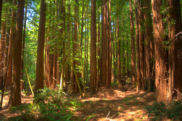
The elevation in the parks ranges from around 200' along the creek to over 2000' on Butano Ridge. The trails vary greatly in difficulty. You can choose anything from a fairly flat route along Old Haul Road to a butt-kicking climb up to Butano Ridge. Except for the Old Haul Road, the trails are primarily singletrack. The trails are generally well-maintained and well-marked, and offer gorgeous forest views.
There are many trailheads to start from. The easiest to access is in Sam McDonald County Park off of Pescadero Road, about a 45-minute drive from Palo Alto. The most remote trailhead is at the Ranger Station in Portola Redwoods State Park, which involves a very twisty drive down Alpine Road and Portola State Park Road. The runs listed on this page start from the Hoffman Flat Trailhead off of Wurr Road, which is about an hour drive from Palo Alto.
There are many trailheads to start from. The easiest to access is in Sam McDonald County Park off of Pescadero Road, about a 45-minute drive from Palo Alto. The most remote trailhead is at the Ranger Station in Portola Redwoods State Park, which involves a very twisty drive down Alpine Road and Portola State Park Road. The runs listed on this page start from the Hoffman Flat Trailhead off of Wurr Road, which is about an hour drive from Palo Alto.
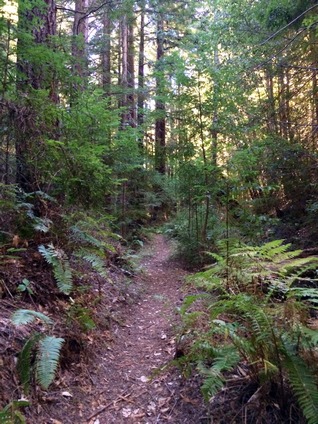
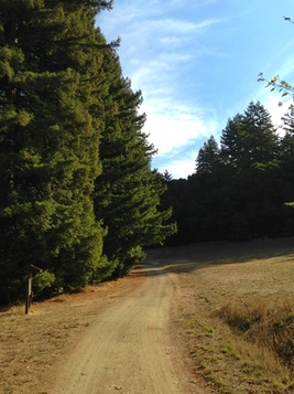 The start of the Old Haul Road
The Dirt:
Extras:
- Click here to download a printable trail map of the Favorite Runs below!
- Click here for the official Pescadero Creek County Park park site with trail map.
- Click here for the official Portola Redwoods State Park site with trail map.
- Click here for directions to the Hoffman Flat Trailhead via Google Maps.
- This area is a hot spot for poison oak. Click here to learn about preventing and treating poison oak rashes.
- There are NO DOGS allowed in these parks.
Extras:
- For those wishing for a very long-distance run/hike, you can connect Portola Redwoods State Park to Long Ridge Open Space Preserve via Slate Creek Trail. You can also connect Pescadero Creek County Park to Big Basin Redwoods State Park via the Basin Trail. You can even can do a 24-mile one-way route from Skyline Blvd through Big Basin all of the way to Pescadero!
- The only potable drinking water is at the Ranger Station in Portola Redwoods State Park. (Note: as of Summer 2014 the water is turned off due to drought!) There may be water at the campgrounds in Memorial Park and Sam McDonald Park, but confirm with a ranger that the water is available and potable prior to your visit. The phone number is 650-879-0238.
Favorite Run #1: Old Haul Out-N-Back (0-11.2 mi, ~0-1000 feet elevation gain)
|
This is a nice introduction to the park along the rolling Old Haul Road. Because the run is an out-and-back, you can go as far as you'd like before turning around. The dirt road/trail is very easy to follow and well-marked as it meanders along Pescadero Creek.
The run starts from the Hoffman Flat Trailhead on Wurr Road. Start the run by crossing the bridge and heading up Old Haul Road. GPX Track Printable Trail Map Driving Directions |
|
Route Details:
- 0.0 mi: Starting from the Hoffman Flat Trailhead, cross the bridge and continue on Old Haul Road. The trail continues for 5.6 miles until you reach private property. Continue as far as you'd like, then turn around!
- 5.6 mi: Old Haul Road ends at a gate. This is as far as you can go, so turn around!
- 11.2 mi: Back at your car!
Favorite Run #2: Ridge/Pomponio Loop (17.3 mi, ~2700 feet elevation gain)
|
This route is a challenging but beautiful loop through Pescadero Creek County Park and Portola Redwoods State Park. After a brief section of the Old Haul Road, you then have a massive climb through a gorgeous redwood forest up to Butano Ridge to visit the highest elevations in the park (at just over 2000'). After spending some time along the ridge, you then descend many switchbacks into Portola Redwoods State Park. You briefly visit the tiny Tiptoe Falls, then visit the Ranger Station for water, and finally head back along the beautiful rolling Pomponio Trail.
The run starts from the Hoffman Flat Trailhead on Wurr Road. Start the run by crossing the bridge and heading up Old Haul Road. GPX Track Printable Trail Map Driving Directions |
|
|
Route Details:
|
Switchback on Butano Ridge Loop Trail
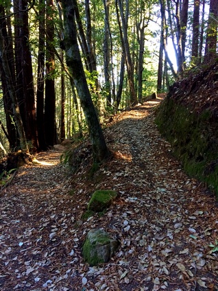
The Portola Trail
|