San Bruno Mountain State and County Park
|
The Dirt:
Extras:
|
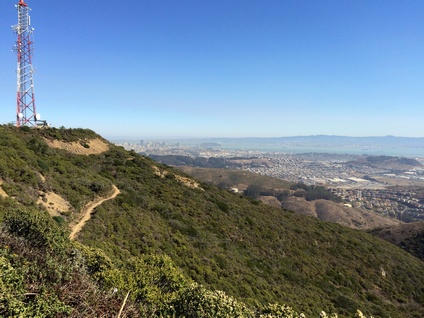
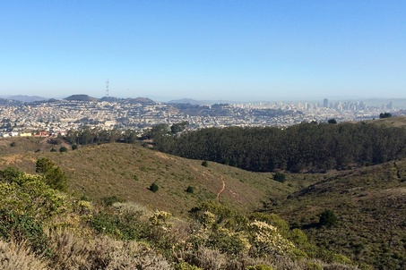
The view from Radio Peak
|
San Bruno Mountain State and County Park is located on the peninsula about 5 miles south of downtown San Francisco. The 2,326 acre park borders the cities of Brisbane, South San Francisco, Colma and Daly City. The park is a unique open-space island in the midst of the San Francisco Peninsula's urbanization. The centerpiece of the park is San Bruno Mountain which is topped by a four mile long ridge. At 1,319', Radio Peak is the highest point along the ridge, and is host to several radio broadcast towers.
The park offers about 10 miles of trails, which are a mix of dirt roads and singletrack. Elevations in the park range from about 250' to 1,319' at Radio Peak, and the trails to the summit afford expansive views of the San Francisco Bay Area. The trails range from moderate to very steep.
Also at the summit stands the remains of an old Nike Missile early warning radar site. This was part of a network of Nike Missile sites which ringed the Bay Area during the Cold War. To read more about the Nike Missile program, check out "The Story of Nimitz Way, Nike Missle Bases, and the Cold War" on the Wildcat Canyon page.
There are a few different trailheads to access the trails. The main access points are from the park's entrance or from Radio Road at the mountain's summit. In addition, various neighborhood access points, including Crocker Road and Charter Street, provide good starting points.
Colma: City of The Dead
 One of Colma's seventeen cemeteries
Just to the south of San Bruno Mountain lies the Town of Colma, which has a unique distinction. The city's dead residents outnumber the living residents by a factor of 1000 to 1! As of 2015, the town has about 1,500 residents, and about 1.5 million bodies buried in its seventeen cemeteries. In fact, cemeteries account for about 73% of the total acreage of the two-square-mile town. How did this happen?
In 1900, the San Francisco City Fathers passed a bill stating that no further burials would be allowed in the City & County of San Francisco. With no further burials, the cemeteries became a place of neglect and vandalism. They then became a health hazard. So, in August of 1912 the San Francisco's Board of Supervisors declared intent to evict all cemeteries in their jurisdiction. Residents then turned to Colma, just south of San Francisco, as a place to bury their dead. After over 20 years and numerous legal battles, all bodies were ordered to be removed from cemeteries within San Francisco. So, Colma cemeteries inherited hundreds of thousands of additional bodies. This led to the incorporation of the cemetery area that became known as Lawndale on August 5, 1924. The town kept the name Lawndale until the United States Postal Service informed the town that there was a Lawndale in Southern California. The town then went back to the original name of Colma in 1941.
Colma’s living-to-dead ratio of residents has earned the city some morbid monikers, such as "City of Souls" and "City of the Silent." Ironically, or perhaps due to a little graveyard humor on the part of the local chamber of commerce, the city’s official slogan is actually, "It’s great to be alive in Colma."
Favorite Run #1: Summit Loop Plus (4.3 mi, ~700' elevation gain)
|
This is a short but challenging loop that incorporates the challenging Summit Loop Trail with a side trip to the 1,319' Radio Peak for spectacular views of San Francisco and surrounding cities. The route is almost entirely singletrack, except for the small dirt road section to the peak.
This run starts from the main parking lot at the saddle. Begin the loop by running south under Guadalupe Canyon Parkway to the trailhead for the Summit Loop Trail. GPX Track Printable Trail Map Driving Directions |
|
Route Details:
|
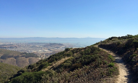
The Ridge Trail
View of San Francisco from Summit Loop Trail
|
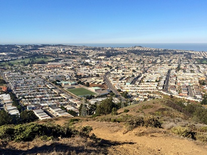
Favorite Run #2: South Side Loop (6.7 mi, ~1100' elevation gain)
|
This 6.7-mile loop allows you to access the summit directly from the neighborhoods in Colma and Daly City, using an unofficial but well-used trail. There is one caveat; the trail is extremely steep! But, you are quickly rewarded with stunning views of the entire peninsula. To make this route a loop, it incorporates about 2.5 miles of pavement to return back to where you started. But, even the road section is very interesting as it passes by several of Colma's huge cemeteries.
Note that this run does NOT start from the main parking lot at the saddle. Instead, this run starts from Hoffman Street in Daly City. You can park anywhere along Hoffman Street north of Hillside Boulevard. To begin the run, head north on Hoffman Street toward San Bruno Mountain. GPX Track Printable Trail Map Driving Directions |
|
Route Details:
|
Outstanding view from the "unofficial trail"
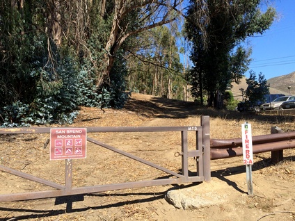
The gate where Fire Road 2-A hits Hillside Blvd
|