Wunderlich County Park
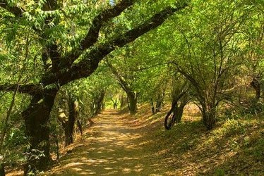
Wunderlich County Park is located in the hills above the town of Woodside. The park is named after Martin Wunderlich, who purchased the property in 1956 and deeded it to San Mateo County for use as a public park in 1974. At one time a working ranch, Wunderlich Park contains over 900 acres of redwood forest, open meadows, and beautiful oaks and madrones. The park is largely open space, with a system of beautiful trails that are popular with hikers, runners, and equestrians.
Wunderlich Park is also home to the the magnificent Folger Stable, once part of the estate of the Folgers Coffee family who owned the property from 1902 to 1956. After extensive renovations, the Folger Stable and surrounding buildings were opened to the public in 2010, with the original Carriage Room in the main stable transformed into a museum that showcases local history.
The park contains about 15 miles of developed trails. The trails are mainly fire roads, with the exception of the Bear Gulch Trail and Redwood Trail. The weather is typically mild and the trails are shaded, which makes Wunderlich a great place to visit in the summertime. Elevations in the park range from about 500 feet at the park entrance to over 2,000 feet at Skyline Blvd.
The main parking area and trailhead for Wunderlich Park is off of Woodside Road (Hwy 84) between Woodside and Portola Valley. All of the runs on this page start from this parking area. (Note there is no fee to park here.)
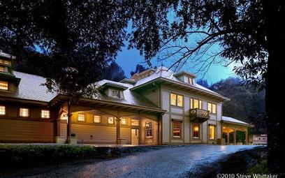 The newly renovated Folger Stable
The Dirt:
Extras:
- Click here for a printable map of the Favorite Runs below!
- Click here for the official park site with trail map.
- Click here for driving directions to the parking area via Google Maps.
- There are NO DOGS allowed in the park.
Extras:
- The only drinking water available in the park is in the main parking lot at the start/finish.
- If you want to do a longer run than the ones listed on this page, you can connect Wunderlich Park to Huddart Park via the 6-mile Skyline Trail which connects to the top of the Alambique Trail at Skyline Blvd. This leads to multiple options including a Huddart/Wunderlich Super Loop!
Please note: A major landslide in 2017 caused the closure of a section of the Alambique Trail between Bear Gulch Trail and The Crossroads. As of November 2017 a new Bypass Trail has been cut to regain access to Skyline, so the Favorite Runs below can be done again. However, a small detour is required. Click here for a detailed map of the closure and new Bypass Trail.
Favorite Run #1: Bear Gulch/Alambique Loop (4.7 mi, ~1000 feet elevation gain)
|
This run is a nice introduction to Wunderlich County Park. The route first takes you up the narrow Bear Gulch Trail through dense redwood forest. This is followed by a three-mile descent back to your car.
The run starts from the main parking area off of Woodside Road (Hwy 84) between Woodside and Portola Valley. Park by the stables, and then head up behind the stables where you will find the well-marked trailhead for the narrow Bear Gulch Trail. GPX Track Printable Trail Map Driving Directions |
|
Route Details:
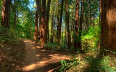 Heading up Bear Gulch Trail
- 0.0 mi: Head up behind the stables to start out on Bear Gulch Trail. You will start gradually climbing.
- 0.2 mi: Pass Loop Trail, continue up Bear Gulch Trail.
- 0.7 mi: Cross Madrone Trail, continue up Bear Gulch Trail.
- 1.2 mi: Pass connector trail on your right.
- 1.4 mi: At Redwood Flat. Continue up Bear Gulch Trail.
- 2.2 mi: At The Meadows. Proceed straight across the meadow to continue on Bear Gulch Trail.
- 2.5 mi: Intersection with Alambique Trail. Turn left and start descending.
- 2.7 mi: Pass Oak Trail, continue on Alambique Trail.
- 3.9 mi: Pass Redwood Trail on your left, continue on Alambique Trail.
- 4.0 mi: Veer right to continue on Alambique Trail
- 4.7 mi: Back at the car!
Favorite Run #2: Skyline Figure-8 (10.3 mi, ~2000 feet elevation gain)
|
This run is an extended version of Favorite Run #1 that takes you all of the way up to Skyline Blvd. The first half of this run is a continuous but gradual 5-mile climb from the parking lot to Skyline Blvd. As you climb towards Skyline you enter a dense redwood forest. After reaching Skyline, you are rewarded with a 5-mile descent back to your car!
The run starts from the main parking area off of Woodside Road (Hwy 84) between Woodside and Portola Valley. Park by the stables, and then head up behind the stables where you will find the well-marked trailhead for the narrow Bear Gulch Trail. GPX Track Printable Trail Map Driving Directions |
|
Route Details:
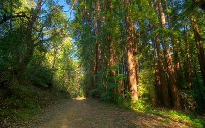 The upper part of Alambique Trail
- 0.0 mi: Head up behind the stables to start out on Bear Gulch Trail. You will start gradually climbing.
- 0.2 mi: Pass Loop Trail, continue up Bear Gulch Trail.
- 0.7 mi: Cross Madrone Trail, continue up Bear Gulch Trail.
- 1.2 mi: Pass connector trail on your right.
- 1.4 mi: At Redwood Flat. Continue up Bear Gulch Trail.
- 2.2 mi: At The Meadows. Proceed straight across the meadow to continue on Bear Gulch Trail.
- 2.5 mi: Intersection with Alambique Trail. Turn right and keep climbing.
- 3.1 mi: At The Crossroads. Continue up the Alambique Trail.
- 5.1 mi: Alambique Trail ends at Skyline Blvd. Turn left onto the Skyline Trail. The Skyline Trail will continue climbing for a bit and then start descending for a few miles.
- 7.5 mi: Back at The Crossroads. Continue onto the Alambique Trail in a downhill direction (if you are climbing you turned the wrong way!!).
- 8.1 mi: Pass Bear Gulch Trail on your left. Continue down on Alambique Trail.
- 8.3 mi: Pass Oak Trail, continue on Alambique Trail.
- 9.5 mi: Pass Redwood Trail on your left, continue on Alambique Trail.
- 9.6 mi: Veer right to continue on Alambique Trail
- 10.3 mi: Back at the car!