Coal Mine Ridge and Portola Valley Ranch Trails
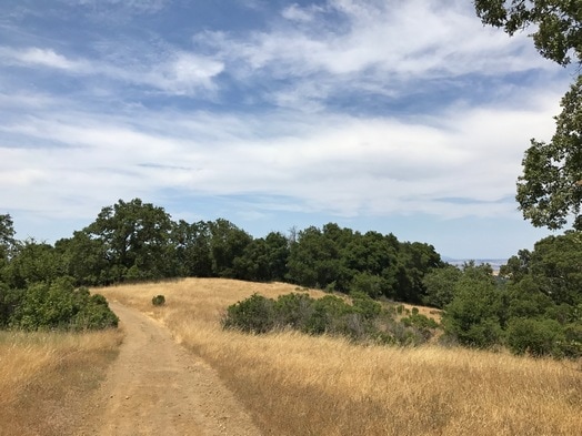
The town of Portola Valley is a runner's and hiker's paradise, with as many miles of trails as there are paved roads. In addition to the nearby open spaces, Windy Hill Open Space Preserve and Coal Creek Open Space Preserve, the town also maintains its own network of trails. The trails are interwoven throughout the town, connecting to residential streets. The highlight of the Portola Valley trail system is Coal Mine Ridge. This 400-acre wooded ridge, located between Alpine Road and Los Trancos Road, contains about ten miles of trails. The elevation varies from about 700' to 1200', and the trails are primarily singletrack. The trails are shaded, which makes Coal Mine Ridge a great place to run during the hot summer months.
The name "Coal Mine Ridge" comes from a low-grade coal mine that was opened on the ridge in 1855. However, a massive landslide in 1890 buried the mine, which never produced high-quality coal anyway.
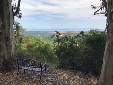
One of the highlights of the area is the Old Spanish Trail. The first record of this trail occurs in an 1823 account of Spanish soldiers pursuing Pomponio, an escaped mission Indian who was on a crime rampage. Historians believe the soldiers rode up the Old Spanish Trail to his hideout in a deep, rocky gorge west of Skyline. Today, the Old Spanish Trail offers some of the best views in Coal Mine Ridge, with vistas extending all of the way to San Francisco on a clear day.
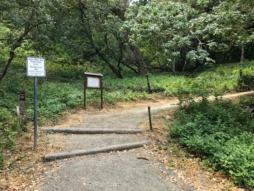
There are a few different trailheads for the Coal Mine Ridge trails. The most accessible is the Alpine Trailhead near the intersection of Alpine Road and Willowbrook Drive in Portola Valley. Roadside parking is available near the trailhead.
The name "Coal Mine Ridge" comes from a low-grade coal mine that was opened on the ridge in 1855. However, a massive landslide in 1890 buried the mine, which never produced high-quality coal anyway.
One of the highlights of the area is the Old Spanish Trail. The first record of this trail occurs in an 1823 account of Spanish soldiers pursuing Pomponio, an escaped mission Indian who was on a crime rampage. Historians believe the soldiers rode up the Old Spanish Trail to his hideout in a deep, rocky gorge west of Skyline. Today, the Old Spanish Trail offers some of the best views in Coal Mine Ridge, with vistas extending all of the way to San Francisco on a clear day.
There are a few different trailheads for the Coal Mine Ridge trails. The most accessible is the Alpine Trailhead near the intersection of Alpine Road and Willowbrook Drive in Portola Valley. Roadside parking is available near the trailhead.
|
The Dirt:
Extras:
|
Alpine Trailhead on Alpine Road
|
Favorite Run #1: Grand Tour (6.5 mi, ~1000 feet elevation gain)
|
This moderate run covers many of the best trails within Coal Mine Ridge, including the Coal Mine Trail, Toyon Trail, and the Old Spanish Trail. Please note that there are many trails in a small area, and the route as described has many twists and turns. Make sure to bring a map and check the trail markers carefully! The good thing is that it is hard to get completely lost in Coal Mine Ridge, as you are never very far from a residential street.
This run starts from the Alpine Trailhead, at the intersection of Alpine Road and Willowbrook Drive in Portola Valley. Begin the run by heading up Alpine Trail. Note that this route is NOT dog-friendly. :( GPX Track Printable Trail Map Driving Directions |
|
Route Details:
|
Views on Old Spanish Trail
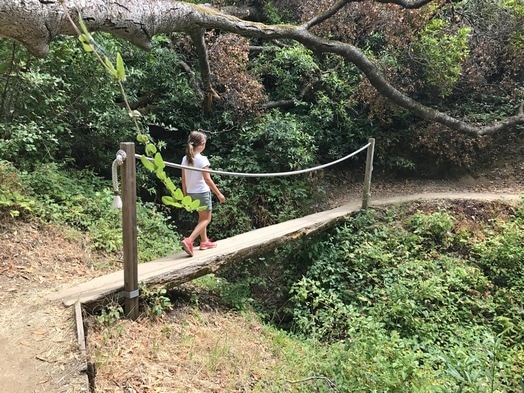
The log bridge on Toyon Trail
|