Trailstompers Guide to SF Bay Area Trail Running
  • Home
  • About
  • Links
  • FAQ
  • Contact
  • Advertise
  • COVID-19

Giant Portola Valley Super-Loop (17.5 mi, ~2800 feet elevation gain)

This amazing adventure loop starts in Portola Valley and hits trails in four parks: Coal Mine Ridge (Portola Valley Ranch), Coal Creek Open Space Preserve, Russian Ridge Open Space Preserve, and Windy Hill Open Space Preserve. Starting from the Windy Hill parking lot, the route climbs for about 6 miles through Windy Hill, Coal Mine Ridge, and Coal Creek. After a short section on Page Mill Road you reach Skyline Blvd. You then climb to 2572' Borel Hill for spectacular vistas of the Bay Area and the Pacific Ocean. This is followed by an awesome section of the Ridge Trail with stunning views the entire way. Finally you head back to Windy Hill for a lush section of the Lost Trail followed by an exciting 3-mile singletrack descent. If you want to visit Windy Hill Summit, there is an optional 2.2-mile out-and-back that adds 200' of climbing to the run!

There are two water stops along this route. The first is a drinking fountain behind the Alpine Pond Nature Center at mile 7 of the run. The second is a spring-fed pipe sticking out of the ground along the Lost Trail at mile 12. Although this pipe is not labeled as "potable" we have been drinking it for years. But, you should drink at your own risk!

This route is primarily singletrack, with the exception of the dirt Old Alpine Road Trail and a few sections of paved road used to connect the parks (about 1.5 miles of paved road total).
The Dirt:
  • Click here to download a printable 3-page trail map of the route!
  • Click here to download the GPX track of this route!
  • Click here for driving directions to the Windy Hill parking lot via Google Maps.

Extras:
  • If you want to add a visit to Windy Hill Summit, there is an optional out-and-back that adds 2.2 miles and 200' of climbing to the run! Check mile 14 of the route details below.
Route Details:
This route can be tricky to follow in some cases, so we recommend that you print out the 3-page trail map or download the GPX track to your GPS device!
  • 0.0 mi: From the Windy Hill parking lot, head up the main trail by the bathroom. After 500 feet, veer left onto Spring Ridge Trail.
  • 0.6 mi: Stay left to continue on the lower Spring Ridge Trail (don't turn right and climb up the steep hill)
  • 0.8 mi: Turn left onto the gravel driveway and descend to Alpine Road.
  • 0.9 mi: Just after crossing the bridge, turn left onto the paved Alpine Road, then turn right on Alpine Trail to enterCoal Mine Ridge (Portola Valley Trails). Follow signs for Toyon Trail.
  • 1.1 mi: Turn right onto the Toyon Trail. You will follow this trail for the next 2.2 miles as it gradually climbs.
  • 3.3 mi: After a tight switchback, veer right onto the Lake Trail.
  • 3.6 mi: Lake Trail ends on Alpine Road. Turn left and continue running up the paved Alpine Road for a half-mile.
  • 4.0 mi: At the gate, veer right onto the dirt Old Alpine Road Trail. You will follow this old road for the next 2.4 miles all of the way up to Skyline Blvd! Partway up this trail you will be diverted onto a Bypass Trail to avoid a washed out section.
  • 6.4 mi: Old Alpine Road Trail ends at Page Mill Road. Turn right on Page Mill Road and follow this road all of the way to Skyline Blvd. Note that Page Mill Road is a curvy paved road with crazy drivers on the weekend, so be careful and run on the shoulder if possible.
  • 7.1 mi: (Water available) Cross Skyline Blvd and take the first trail on the left to head down to Alpine Pond. Go around to the far side of the pond to the Nature Center to get water.
  • 7.6 mi: After getting water, continue around the pond and head through the tunnel under Alpine Road into the Russian Ridge Open Space Preserve parking lot. Continue through the parking lot onto the Ridge Trail. Continue on the Ridge Trail as it climbs up to Borel Hill, the high point of the run.
  • 8.4 mi: At 2572' Borel Hill summit! Enjoy the view, then continue on the Ridge Trail as it descends the other side of Borel Hill.
  • 8.9 mi: At the 4-way trail junction, continue straight on the Ridge Trail.
  • 9.6 mi: Veer right onto the singletrack to continue on the Ridge Trail. Over the next mile, you will cross over several driveways and dirt roads, but continue on the singletrack Ridge Trail. The views from the trail are spectacular!
  • 10.8 mi: Ridge Trail ends on a dirt road. Continue straight ahead on this dirt road. After a quarter-mile, veer right onto Rapley Ranch Road toward Skyline Blvd.
  • 11.1 mi: Turn left onto Skyline Blvd and run along the shoulder for 0.8 miles. Watch out for fast drivers! Look for the Lost Trail trailhead on your right.
  • 11.9 mi: Turn right onto Lost Trail and enter Windy Hill Open Space Preserve. You will descend several sharp switchbacks.
  • 12.2 mi: (Water available) Veer left at the intersection with Razorback Ridge Trail to stay on Lost Trail. Immediately after this intersection, you will see a pipe sticking out of the ground emptying into a small metal tub. This water is not officially potable, but we have been drinking it for years. Drink at your own risk!! Then continue on the rolling, lush Lost Trail.
  • 13.7 mi: Cross over a dirt road to continue on the singletrack Lost Trail.
  • 14.0 mi: Turn right onto Hamms Gulch Trail to begin a 3-mile descent. (Note: if you want to add the 2.2-mile out-and-back to Windy Hill summit, continue straight on the Lost Trail for 0.4 miles to the parking lot, then veer right onto the Anniversary Trail to the summit. After visiting the summit, return to this point and turn left onto Hamms Gulch Trail.)
  • 16.4 mi: At the trail junction, stay left to continue downhill on Hamms Gulch Trail. you will soon cross a rocky creek and then start climbing.
  • 16.8 mi: You will pass two trails, but continue heading straight ahead up to the dirt driveway. Cross over the dirt driveway to get onto Spring Ridge Trail. This should now look familiar! Follow Spring Ridge Trail all of the way back to your car.
  • 17.5 mi: Back at your car!

Picture
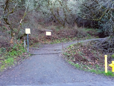
Coal Mine Ridge Trailhead on Alpine Road (mile 1)
Picture
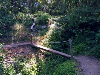
Log bridge on the Toyon Trail (mile 2.5)
Picture
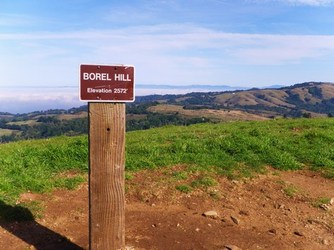
Views from Borel Hill (mile 8.4)
Picture
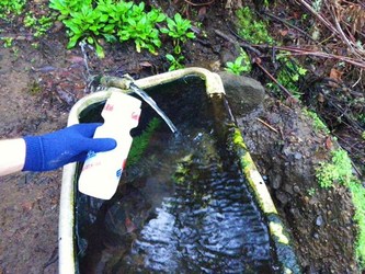
The pipe along the Lost Trail. Safe? (mile 12)
Picture
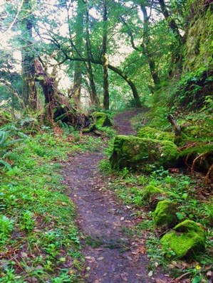
Lost Trail in Windy Hill OSP (mile 13)

Comments:


© 2017 Trailstompers.com.  All rights reserved.
Advertise on Trailstompers