South Skyline Region: Russian Ridge OSP - Skyline Ridge OSP - Long Ridge OSP - Monte Bello OSP - Upper Stevens Creek County Park
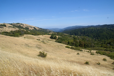
The South Skyline Region is a massive area of interconnected parks and open space preserves, located in the hills of the southern portion of the San Francisco peninsula, spanning from Cupertino northward to Palo Alto. This area was once the site of extensive logging operations in the nineteenth century. One legacy of the logging operations is the "Skid Road Trail" in Monte Bello Open Space Preserve. This road was once traversed by nineteenth century loggers who used oxen to drag huge Coast Duglass-firs and smaller Tanbark oak trees along "skids" which were flat-topped logs doused with water to reduce friction. After the logging operations ceased, Italian farmers and winemakers settled on the flanks of Monte Bello Ridge. Dairies in the Santa Cruz Mountains supplied much of the milk for the San Francisco Peninsula. There was a large dairy near what is now the preserve's main parking area on Page Mill Road, and cattle freely grazed the slopes of Monte Bello Ridge.
Today, this area offers dozens of miles of challenging trails with spectacular views. If you include other adjoining parks (Rancho San Antonio, Castle Rock, Big Basin, etc.) it is possible to continuously run or hike all of the way from Cupertino to the Pacific Ocean without ever stepping on a paved road! The trails are a mix of singletrack and fire roads, with elevations ranging from about 1000' at the bottom of the Canyon Trail to over 2800' at the top of Black Mountain. The trails range from moderate (such as the Chestnut and Peters Creek Trails) to difficult (such as Grizzly Flat Trail, Table Mountain Trail, and the Canyon Trail). Many of the trails also allow mountain bikes. There are multiple trailheads to start from along Skyline Blvd, Page Mill Road, Alpine Road, or Hwy 9.
Wait... Did you say "Grizzly Flat" Trail?? Who's ever heard of a grizzly bear in the Bay Area? It turns out that the California grizzly was a native of the San Francisco Bay Area. Unfortunately, the bears are long gone ever since the last grizzly in all of California was killed in the Sierra foothills east of Fresno in August 1922.
Note: Even though the Canyon Trail is a wide fire road in most sections, it is a popular trail for mountain bikers, particularly in the downhill direction. Please be cautious and watch out for bikers when you are running or hiking on the Canyon Trail!
The Dirt:
- Click here for a printable trail map of the Favorite Runs below!
- For the official OpenSpace.org website click here.
- For maps of Russian Ridge, Skyline Ridge, Long Ridge, and Monte Bello click here. (Click on the link at the left side of the page for the "South Skyline Region" map. The map is also freely available in printed form at most trailheads.)
- For the official site and trail map of the Stevens Creek County Park area click here. (Scroll to the bottom of the page for the trail map.)
- There are so many different trailheads in this region that the driving directions are listed with each run below.
- South Skyline is a hot spot for poison oak. Click here to learn about preventing and treating poison oak rashes.
- Dogs on leash are allowed only in Upper Stevens Creek County Park. For this reason, none of the Favorite Runs below are dog-friendly. :(
|
Extras:
|
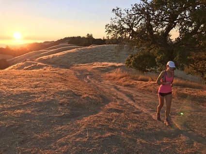
An evening run along Long Ridge
|
Favorite Run #1: Table Mtn/Grizzly Flat Loop (9.9 mi, ~1600 feet elevation gain)
|
This run is a nice loop that takes you from the ridgeline along Skyline all of the way down to the bottom of Stevens Creek Canyon on the narrow Table Mountain Trail. This section of Table Mountain Trail is some of the best singletrack in the area. You then have a long, moderate climb all of the way back up to Skyline on the Grizzly Flat Trail.
This run starts at the Grizzly Flat Trailhead on Skyline Blvd about 3.3 miles north of Hwy 9. If you are driving north from Hwy 9, the parking area will be on your right. Begin the run by crossing over Skyline Blvd and getting on Peters Creek Trail. GPX Track Printable Trail Map Driving Directions |
|
Route Details:
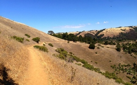
 Heading down Table Mountain Trail
- 0.0 mi: Cross over Skyline Blvd and get on the Peters Creek Trail.
- 0.4 mi: Ridge Trail intersection. Turn left to continue on the Peters Creek Trail. (You're now on the Bay Area Ridge Trail.)
- 0.5 mi: Long Ridge Trail intersection. Stay to the left on the Peters Creek Trail. Continue on the Peters Creek Trail for the next 1.6 miles. You'll pass a small lake and then switchback up a hill.
- 2.1 mi: Turn left onto Ward Road toward Saratoga Gap/Hwy 9 (follow the Bay Area Ridge Trail).
- 2.2 mi: Trail intersection. Keep heading toward Hickory Oaks Trail and Saratoga Gap/Hwy 9 (follow the Bay Area Ridge Trail).
- 2.4 mi: Turn left onto Hickory Oaks Trail heading toward Saratoga Gap/Hwy 9 (follow the Bay Area Ridge Trail).
- 2.9 mi: Trail splits. Take either direction, since they join up again soon (the trail to the right has a view!).
- 3.2 mi: After a small climb, turn left at the Achistaca Trail junction and descend to Skyline Blvd.
- 3.3 mi: Cross Skyline and get onto the Saratoga Gap trail (follow the Bay Area Ridge Trail).
- 3.6 mi: Trail ends at Charcoal Road. Get onto the Table Mountain Trail singletrack, which veers off to the left of Charcoal Road. The next few miles are a long rolling descent to Stevens Creek.
- 6.3 mi: The singletrack comes out to a fire road. Continue straight ahead on the fire road, then turn left to continue on Table Mountain Trail towards Stevens Creek Canyon Trail.
- 7.5 mi: Table Mountain Trail ends at the Canyon Trail. Cross the creek, turn left, and then start climbing. Watch for mountain bikers!
- 7.8 mi: After a short steep climb, turn left onto Grizzly Flat Trail. The initial section of trail is singletrack: you'll descend briefly, cross the creek again, and come out to a fire road. Continue climbing up the Grizzly Flat Trail fire road.
- 8.7 mi: The Grizzly Flat Trail splits. Stay right to continue up the north trail. (Both trails take you to the top, but the north trail is a more gradual climb.)
- 9.5 mi: Stay right at the connector trail to continue up Grizzly Flat Trail.
- 9.9 mi: Back at the car!
Favorite Run #2: Skyline Big Loop (18.7 mi, ~2800 feet elevation gain)
|
This grand loop gives you a long descent down Table Mountain Trail, and a nice long climb up the Canyon and White Oak Trails. As an added bonus you get to experience a beautiful rolling section through Skyline Ridge OSP with amazing views, and there's even a water stop at the Alpine Pond Nature Center! The turns are a bit confusing, so it is a good idea to carry a trail map or download the GPX track to your GPS device.
This run starts at the Grizzly Flat Trailhead on Skyline Blvd about 3.3 miles north of Hwy 9. If you are driving north from Hwy 9, the parking area will be about on your right. Begin the run by crossing over Skyline Blvd and getting on Peters Creek Trail. GPX Track Printable Trail Map Driving Directions |
|
Route Details:
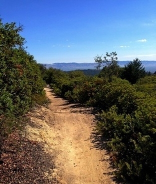
 The Ipiwa Trail in Skyline Ridge OSP
Note: you can make this a 22-mile loop by starting at the Saratoga Gap parking lot at the intersection of Skyline Blvd and Hwy 9. In this case you would take the Saratoga Gap Trail north to the top of Table Mountain Trail (mile 3.3 in the directions below). Then follow the directions below to mile 18.3, then the directions from mile 0.4 through 3.2. Instead of turning left at mile 3.2, continue straight ahead on Achistaca Trail to Hwy 9, cross over Hwy 9, then turn left on Saratoga Toll Road Trail and follow it back to the Saratoga Gap parking lot.
- 0.0 mi: Cross over Skyline Blvd and get on the Peters Creek Trail.
- 0.4 mi: Ridge Trail intersection. Turn left to continue on the Peters Creek Trail. (You're now on the Bay Area Ridge Trail.)
- 0.5 mi: Long Ridge Trail intersection. Stay left on the Peters Creek Trail. Continue on the Peters Creek Trail for the next 1.6 miles. You'll pass a small lake and then switchback up a hill.
- 2.1 mi: Turn left onto Ward Road toward Saratoga Gap/Hwy 9 (follow the Bay Area Ridge Trail).
- 2.2 mi: Trail intersection. Keep heading toward Hickory Oaks Trail and Saratoga Gap/Hwy 9 (follow the Bay Area Ridge Trail).
- 2.4 mi: Turn left onto Hickory Oaks Trail heading toward Saratoga Gap/Hwy 9 (follow the Bay Area Ridge Trail).
- 2.9 mi: Trail splits. Take either direction, since they join up again soon (the trail to the right has a view!).
- 3.2 mi: After a short climb, turn left at the Achistaca Trail junction and descend to Skyline Blvd.
- 3.3 mi: Cross Skyline and get onto the Saratoga Gap trail (follow the Bay Area Ridge Trail).
- 3.6 mi: Trail ends at Charcoal Road. Get onto the Table Mountain Trail singletrack, which veers off to the left of Charcoal Road. The next 3.3 miles are a long rolling descent to Stevens Creek.
- 6.3 mi: The singletrack comes out to a fire road. Continue straight ahead on the fire road, then turn left to continue on Table Mountain Trail towards Stevens Creek Canyon Trail.
- 7.5 mi: Table Mountain Trail ends at the Canyon Trail. Cross the creek, turn left, and then start climbing. Watch for mountain bikers!
- 7.8 mi: Pass Grizzly Flat Trail on your left. Stay on the Canyon Trail.
- 10.0 mi: Intersection with Indian Creek Trail. Turn left to stay on the Canyon Trail.
- 10.3 mi: Turn left through a small gate onto the Stevens Creek Nature Trail. The trail will descend, cross a stream, and then start climbing again.
- 11.0 mi: Stay to the left to get onto Skid Road Trail, heading toward White Oak Trail.
- 11.2 mi: Veer right onto White Oak Trail. This is an awesome 1.4 miles of singletrack! You will descend for a bit then climb up a series of switchbacks.
- 12.4 mi: Near the top of White Oak Trail, you will go through a small gate. Just past the little gate, turn left toward Alpine Road.
- 12.8 mi: Trail ends at Alpine Road (this is a paved road). Turn left and run up Alpine Road to the intersection with Skyline Blvd.
- 13.5 mi: At Skyline Blvd. Cross over Skyline Blvd and run about 100 feet up Alpine Road. You will see the entrance to Russian Ridge Open Space Preserve on your right, and a small singletrack on your left. Turn left onto the singletrack which takes you into Skyline Ridge Open Space Preserve. This is the Sunny Jim Trail. After about 500 feet, take a hard left toward Alpine Pond Trail. This trail will take you around to the backside of Alpine Pond to the Nature Center. There is a water fountain at the Nature Center.
- 13.8 mi: After getting water at the Nature Center, follow signs onto Ipiwa Trail. This trail climbs up the backside of the ridge for some amazing views! Stay on the Ipiwa Trail until it ends at the Sunny Jim Trail (fire road).
- 14.8 mi: Turn right on Sunny Jim Trail, and start a steep descent toward Horseshoe Lake.
- 15.2 mi: Hard right turn onto Horseshoe Loop Trail. This trail takes you around the backside of the aptly named "Horseshoe Lake". The trail will take you across the dam that forms this small lake. Follow Horseshoe Loop Trail until you see Fir Knoll Trail on your right.
- 15.4 mi: Turn right onto Fir Knoll Trail. This is a nice, shaded singletrack climb.
- 16.0 mi: Fir Knoll Trail ends. Turn right onto Tree Farm Trail, toward the Christmas Tree Farm. Continue following the "TRAIL" signs (and the Bay Area Ridge Trail Signs).
- 16.7 mi: After an absurdly steep climb, turn right onto Chestnut Trail (follow the Bay Area Ridge Trail) toward Long Ridge OSP. Keep following the signs for Chestnut Trail for the next 1.3 miles. The trail will cross several driveways as you parallel Skyline Blvd.
- 18.3 mi: At the Peters Creek Trail junction, turn left to head toward Grizzly Flat Trailhead parking.
- 18.7 mi: Back at your car!